www.lowrance.com
Pub. 988-0151-481
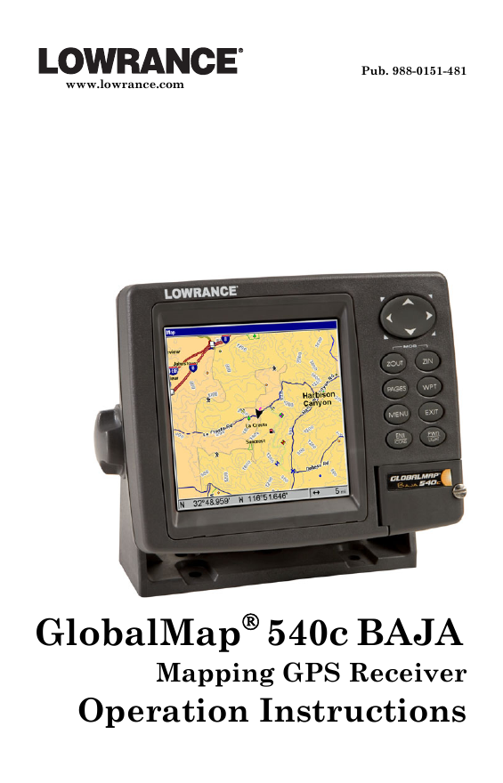
GlobalMap® 540c BAJA
Mapping GPS Receiver
Operation Instructions
�
Copyright © 2006 Lowrance Electronics, Inc.
All rights reserved.
No part of this manual may be copied, reproduced, republished, trans-
mitted or distributed for any purpose, without prior written consent of
Lowrance. Any unauthorized commercial distribution of this
manual is strictly prohibited.
Lowrance® is a registered trademark of Lowrance Electronics, Inc.
MapCreate™, FreedomMaps™ and NauticPath™ are trademarks of
LEI. Fishing Hot Spots® is a registered trademark of Fishing Hot Spots
Inc. LakeMaster® and Pro Maps are trademarks or registered trade-
marks of WayPoint Technologies, Inc. Navionics® is a registered
trademark of Navionics, Inc. DURACELL® is a registered trademark of
Duracell, Inc. RAYOVAC® is a registered trademark of Rayovac Corpo-
ration. Energizer® and e2® are registered trademarks of Energizer Hold-
ings, Inc.
Points of Interest Data in this unit are by infoUSA,
copyright © 2001-2006, All Rights Reserved. infoUSA is a
trademark of infoUSA, Inc.
Lowrance Electronics may find it necessary to change or end our poli-
cies, regulations and special offers at any time. We reserve the right to
do so without notice. All features and specifications subject to change
without notice. On the cover: GlobalMap 540c BAJA. All screens in this
manual are simulated.
For free owner's manuals and the most current information on
this product, its operation and accessories,
visit our web site:
www.lowrance.com
Lowrance Electronics Inc.
12000 E. Skelly Dr.
Tulsa, OK USA 74128-2486
Printed in USA.
�
Table of Contents
Section 1: Read Me First! ......................................................... 1
Specifications: GlobalMap® 540c BAJA....................................... 2
How to use this manual: typographical conventions .................. 8
Section 2: Installation............................................................. 11
Preparations ................................................................................ 11
Power Connections...................................................................... 11
Powering Your Display Unit ...................................................... 12
Power Diagram A ........................................................................ 14
Power Diagram B ........................................................................ 15
Powering a NMEA 2000 Network Bus ...................................... 15
GPS Antenna/Receiver Module.................................................. 16
NMEA 0183 Cable Connections ................................................. 17
NMEA 0183 Wiring................................................................. 18
Mounting the Unit: Bracket or Portable ................................... 20
MMC or SD Card Memory Card Installation............................ 22
Other Accessories ........................................................................ 24
Cleaning Towel........................................................................ 24
Face Cover ................................................................................... 24
Section 3: Basic GPS Operation ........................................... 27
Keyboard...................................................................................... 27
Power/lights on and off ............................................................... 28
Main Menu................................................................................... 28
Pages ............................................................................................ 30
Satellite Status Page............................................................... 30
Navigation Page ...................................................................... 32
Map Page ................................................................................. 35
Background map vs. MapCreate map content ...................... 36
Map with Custom Gauges....................................................... 39
Radar............................................................................................ 40
Basic GPS Quick Reference........................................................ 42
Find Your Current Position........................................................ 43
Moving Around the Map: Zoom & Cursor Arrow Keys............. 43
Selecting Any Map Item With the Cursor................................. 44
Searching ..................................................................................... 44
Set a Waypoint ............................................................................ 46
To create and save a Waypoint:.............................................. 47
Create Waypoint at Current Position................................ 47
Create Waypoint on Map .................................................... 48
Navigate To a Waypoint ............................................................. 48
Set Man Overboard (MOB) Waypoint........................................ 49
Navigate Back to MOB Waypoint.............................................. 49
i
�
Navigate to Cursor Position on Map.......................................... 50
Navigate to a Point of Interest................................................... 51
Creating and Saving a Trail....................................................... 52
Displaying a Saved Trail ............................................................ 54
Navigating Trails ........................................................................ 54
Visual Trailing......................................................................... 55
Navigate a Trail ...................................................................... 55
Navigate a Back Trail (backtrack, or reverse) ...................... 57
Transfer Custom Maps and GPS Data Files............................. 58
Cancel Navigation....................................................................... 60
Section 4: Advanced Operations .......................................... 61
Find Distance from different Locations..................................... 61
Find Distance from Point to Point ............................................. 61
Icons ............................................................................................. 61
Create Icon on Map ................................................................. 62
Create Icon at Current Position ............................................. 62
Delete an Icon.......................................................................... 62
Navigate to an Icon ................................................................. 63
Routes .......................................................................................... 63
Create and Save a Route ........................................................ 64
Delete a Route ......................................................................... 66
Edit a Route Name.................................................................. 66
Edit Route Waypoints............................................................. 67
Navigate a Route..................................................................... 67
Navigate a Route in Reverse .................................................. 68
Trails............................................................................................ 69
Delete a Trail........................................................................... 69
Edit a Trail Name ................................................................... 70
Edit a Trail Color .................................................................... 70
Edit a Trail Pattern................................................................. 70
Utilities ........................................................................................ 71
Alarm Clock ............................................................................. 71
Sun/Moon Rise & Set Calculator............................................ 71
Trip Calculator ........................................................................ 71
Trip Down Timer..................................................................... 71
Trip Up Timer.......................................................................... 71
Waypoints .................................................................................... 71
Delete a Waypoint................................................................... 71
Edit a Waypoint....................................................................... 72
Waypoint Name................................................................... 72
Waypoint Symbol................................................................. 72
Waypoint Position ............................................................... 72
Selecting a Waypoint .............................................................. 73
ii
�
Set a Waypoint by Average Position...................................... 74
Set a Waypoint by Projecting a Position................................ 74
Section 5: System & GPS Setup............................................ 75
Alarms.......................................................................................... 75
Auto Satellite Search .................................................................. 76
Check MMC Files and Storage Space........................................ 77
Communications Port Configuration......................................... 77
Configure NMEA......................................................................... 78
Coordinate System Selection...................................................... 78
Map Fix........................................................................................ 80
Customize Page Displays............................................................ 81
GPS Simulator............................................................................. 82
Initialize GPS .............................................................................. 84
Map Auto Zoom ........................................................................... 85
Map Data ..................................................................................... 85
Map Datum Selection.................................................................. 87
Map Detail Category Selection................................................... 87
Map Orientation.......................................................................... 88
NauticPath™ USA Marine Charts............................................. 89
Nautical Chart Notes.............................................................. 89
Port Information...................................................................... 90
Tidal Current Information...................................................... 91
Tide Information ..................................................................... 93
Navionics® Charts ....................................................................... 94
Overlay Data ............................................................................... 95
Pop-up Help ................................................................................. 99
Reset Options............................................................................... 99
Screen Contrast and Brightness .............................................. 100
Set Language............................................................................. 101
Set Local Time........................................................................... 101
Show WAAS Alarm ................................................................... 103
Software Version Information.................................................. 103
Sounds and Alarm Sound Styles.............................................. 104
Track Smoothing ....................................................................... 105
Trail Options.............................................................................. 105
Transparency............................................................................. 108
Units of Measure....................................................................... 109
Section 6: Searching.............................................................. 113
Find Streets ............................................................................... 113
Find Any Item Selected by Map Cursor .................................. 115
Find Interstate Highway Exits ................................................ 115
Find Map Places or Points of Interest (POI) ........................... 118
Find Streets or Intersections.................................................... 120
iii
�
Find Waypoints ......................................................................... 123
Section 7: NMEA 2000 ........................................................... 127
NMEA 2000 Menu..................................................................... 127
Bus Setup................................................................................... 127
Engine & Tank Configuration.................................................. 128
Tank Select ........................................................................ 129
Tank Size ........................................................................... 129
Set Configuration button .................................................. 129
Device Configuration Menu.................................................. 130
Device Information and Device Data................................... 130
Fuel Management Menu........................................................... 131
Tank Location.................................................................... 131
Fuel Added......................................................................... 131
Add Fuel............................................................................. 132
Fill Tank............................................................................. 132
Adding Fuel to Tank ............................................................. 132
Engine Operations................................................................. 132
Engine Select ..................................................................... 132
NMEA 2000 Alarms.................................................................. 133
Waypoint Sharing ..................................................................... 134
Backlight Synchronization ....................................................... 134
Configuring EP Sensors............................................................ 135
EP-35 Temperature Configuration ...................................... 135
Advanced Options menu....................................................... 135
Instance.............................................................................. 136
Restore Defaults ................................................................ 136
EP-10 Fuel Flow Configuration............................................ 136
Advanced Options menu....................................................... 137
Instance.............................................................................. 137
Restore Defaults ................................................................ 137
EP-15 Fluid Level Configuration ......................................... 138
Advanced Options menu....................................................... 140
Instance.............................................................................. 140
Restore Defaults ................................................................ 140
Suzuki Engine Interface Configuration............................... 141
Advanced Options menu....................................................... 142
Instance.............................................................................. 142
Restore Defaults ................................................................ 142
To restore default settings:............................................... 142
Calibrating EP Sensors............................................................. 143
EP-10 Fuel Flow Calibration................................................ 143
EP-15 Fluid Level Calibration ............................................. 144
2-Point Calibration............................................................ 144
iv
�
3-Point Calibration............................................................ 145
5-Point Calibration............................................................ 146
Fuel Flow Calibration in a Suzuki Engine Interface.......... 147
Engine Trim Calibration....................................................... 148
Reset Trim Calibration ......................................................... 149
Bennett Trim Tabs Calibration............................................ 149
Sec. 8: Supplemental Material............................................ 151
v
�
NOTICE!
The storage and operation temperature range for your unit is from -20
degrees to +167 degrees Fahrenheit (-28 degrees to +75 degrees Cel-
sius). Extended storage or operation in temperatures higher or lower
than specified will damage the liquid crystal display in your unit. This
type of damage is not covered by the warranty. For more information,
contact the factory's Customer Service Department; phone numbers are
listed on the last page of the manual.
WARNING!
A CAREFUL NAVIGATOR NEVER RELIES ON ONLY ONE METHOD
TO OBTAIN POSITION INFORMATION.
When showing navigation data to a position (waypoint), a GPS unit will show
the shortest, most direct path to the waypoint. It provides navigation data to the
waypoint regardless of obstructions. Therefore, the prudent navigator will not
only take advantage of all available navigation tools when traveling to a way-
point, but will also visually check to make sure a clear, safe path to the waypoint
is always available.
CAUTION
WARNING!
When a GPS unit is used in a vehicle, the vehicle operator is solely re-
sponsible for operating the vehicle in a safe manner. Vehicle operators
must maintain full surveillance of all pertinent driving, boating or flying
conditions at all times. An accident or collision resulting in damage to
property, personal injury or death could occur if the operator of a GPS-
equipped vehicle fails to pay full attention to travel conditions and vehi-
cle operation while the vehicle is in motion.
vi
�



 2023年江西萍乡中考道德与法治真题及答案.doc
 2012年重庆南川中考生物真题及答案.doc
 2013年江西师范大学地理学综合及文艺理论基础考研真题.doc
 2020年四川甘孜小升初语文真题及答案I卷.doc
 2020年注册岩土工程师专业基础考试真题及答案.doc
 2023-2024学年福建省厦门市九年级上学期数学月考试题及答案.doc
 2021-2022学年辽宁省沈阳市大东区九年级上学期语文期末试题及答案.doc
 2022-2023学年北京东城区初三第一学期物理期末试卷及答案.doc
 2018上半年江西教师资格初中地理学科知识与教学能力真题及答案.doc
 2012年河北国家公务员申论考试真题及答案-省级.doc
 2020-2021学年江苏省扬州市江都区邵樊片九年级上学期数学第一次质量检测试题及答案.doc
 2022下半年黑龙江教师资格证中学综合素质真题及答案.doc