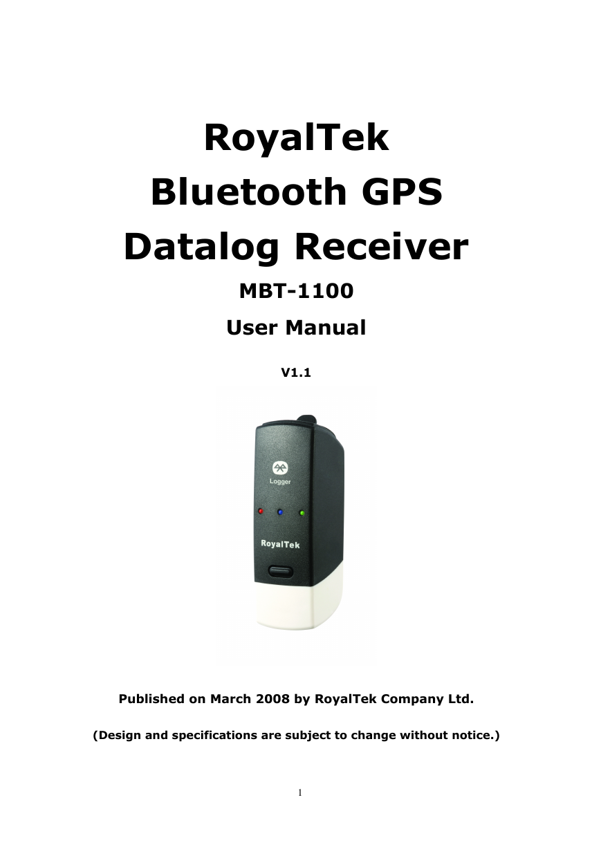
RoyalTek
Bluetooth GPS
Datalog Receiver
MBT-1100
User Manual
V1.1
Published on March 2008 by RoyalTek Company Ltd.
(Design and specifications are subject to change without notice.)
1
�
Content
1. Product Introduction ................................................................ 3
1.1 Overview..........................................................................................................3
1.2 Main Features...................................................................................................3
1.3 Product Notification.........................................................................................3
1.4 Application .......................................................................................................3
1.5 Specification ....................................................................................................4
2. Before Start .............................................................................. 6
2.1 Check the Package Content .............................................................................6
2.2 Power Button (Right View)..............................................................................6
2.3 LED Display ....................................................................................................7
2.4 Hardware Features ...........................................................................................7
2.4.1. Power Button .......................................................................................7
2.4.2. Bluetooth Status LED (Blue) ...............................................................7
2.4.3. GPS Status LED (Green) .....................................................................7
2.4.4. Memory Status LED (Red) ..................................................................8
2.4.5. Battery Status LED (Amber/Yellow) ...................................................8
2.5. Getting Started ................................................................................................8
2.5.1. STEP 1: Turn on Receiver and Wait for GPS Fix ................................8
2.5.2. STEP 2: Connect to Bluetooth-Enabled Devices.................................8
2.5.3. STEP 3: Connect to your Navigation Software ...................................8
2.6 How to use Car Charger to charge your handheld device................................9
3. Utility Installation .................................................................. 10
3.1 Install USB Driver (Windows 2000/XP/2003) or (Windows
Vista family).................................................................................................. 11
3.2 Install Data download Utility.........................................................................13
3.3 Transfer data to your PC or Notebook ...........................................................17
3.3.1 Connect MBT-1100.............................................................................17
3.3.2 Download Data ...................................................................................18
3.3.3 Get and Set MBT-1100 Device Status ................................................19
3.3.4 Get the Data Logger Data Downloader revision information.............22
2
�
1. Product Introduction
1.1 Overview
The MBT-1100 is equipped with the latest GPS solution for fast and accurate fix
on GPS signals. This latest round of technology advancements gives the users
an “instant on” feel, and the experience in navigation becomes more natural.
The dimension of 69.5(L) x 23(W) x 20(H) and weight only 38g, making it an
ideal solution to carry everywhere.
1.2 Main Features
� NMEA0183 compliant protocol
� Extreme fast TTFF at low signal level.
� Adopt TCXO as GPS core clock source
� Industrial Standard
� Selectable Baud Rate
� WAAS / ENGOS is supported
1.3 Product Notification
� Charger operating temperature range 0 ºC to +50 ºC
� Discharger operating temperature range -20 ºC to +60 ºC
� Battery Storage temperature range -20 ºC to +60 ºC
� 10hr at full charge continuous operation mode.
� Humidity range up to 95% no condensing
1.4 Application
� PDA and Cellular Phone Navigation
� Consumer wireless GPS
� Automotive Vehicle Tracking
� Personal Positioning
� Sporting and Recreation
3
�
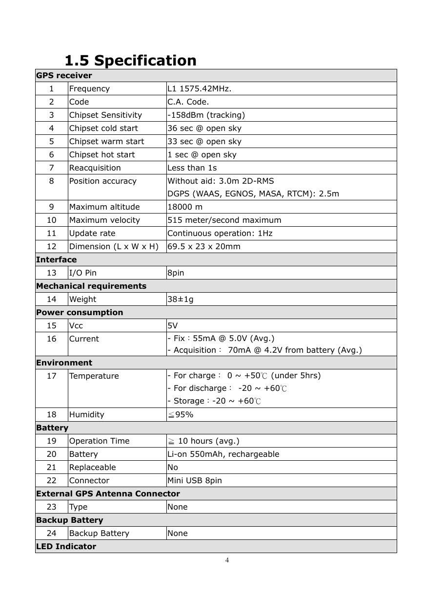
1.5 Specification
GPS receiver
1
2
3
4
5
6
7
8
Frequency
Code
L1 1575.42MHz.
C.A. Code.
Chipset Sensitivity
-158dBm (tracking)
Chipset cold start
36 sec @ open sky
Chipset warm start
33 sec @ open sky
Chipset hot start
1 sec @ open sky
Reacquisition
Less than 1s
Position accuracy
Without aid: 3.0m 2D-RMS
DGPS (WAAS, EGNOS, MASA, RTCM): 2.5m
9 Maximum altitude
18000 m
10 Maximum velocity
515 meter/second maximum
11 Update rate
Continuous operation: 1Hz
12 Dimension (L x W x H) 69.5 x 23 x 20mm
Interface
13
I/O Pin
8pin
Mechanical requirements
14 Weight
38±1g
Power consumption
15 Vcc
16 Current
Environment
5V
- Fix:55mA @ 5.0V (Avg.)
- Acquisition: 70mA @ 4.2V from battery (Avg.)
17
Temperature
- For charge: 0 ~ +50℃ (under 5hrs)
- For discharge: -20 ~ +60℃
- Storage:-20 ~ +60℃
18 Humidity
≦95%
Battery
19 Operation Time
≧ 10 hours (avg.)
20 Battery
Li-on 550mAh, rechargeable
21 Replaceable
No
22 Connector
Mini USB 8pin
External GPS Antenna Connector
23
Type
Backup Battery
None
24 Backup Battery
None
LED Indicator
4
�
25 Status
26 Original Display
LEDs showing GPS, Bluetooth, Power, Memory status
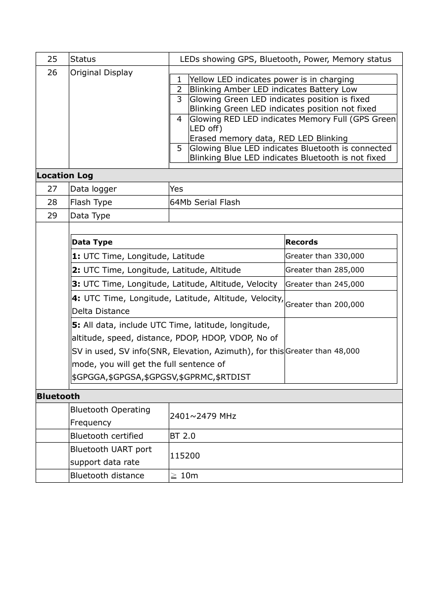
1 Yellow LED indicates power is in charging
2 Blinking Amber LED indicates Battery Low
3 Glowing Green LED indicates position is fixed
Blinking Green LED indicates position not fixed
4 Glowing RED LED indicates Memory Full (GPS Green
LED off)
Erased memory data, RED LED Blinking
5 Glowing Blue LED indicates Bluetooth is connected
Blinking Blue LED indicates Bluetooth is not fixed
Location Log
27 Data logger
Yes
28
Flash Type
29 Data Type
Data Type
64Mb Serial Flash
Records
1: UTC Time, Longitude, Latitude
Greater than 330,000
2: UTC Time, Longitude, Latitude, Altitude
Greater than 285,000
3: UTC Time, Longitude, Latitude, Altitude, Velocity Greater than 245,000
4: UTC Time, Longitude, Latitude, Altitude, Velocity,
Delta Distance
5: All data, include UTC Time, latitude, longitude,
altitude, speed, distance, PDOP, HDOP, VDOP, No of
Greater than 200,000
SV in used, SV info(SNR, Elevation, Azimuth), for this
Greater than 48,000
mode, you will get the full sentence of
$GPGGA,$GPGSA,$GPGSV,$GPRMC,$RTDIST
Bluetooth
Bluetooth Operating
Frequency
2401~2479 MHz
Bluetooth certified
BT 2.0
Bluetooth UART port
support data rate
115200
Bluetooth distance
≧ 10m
�
2. Before Start
2.1 Check the Package Content
Before you start using MBT-1100, please check out if your package includes the
following items. If any item is damaged or missed, please contact your reseller at
once.
● MBT-1100 Bluetooth GPS datalog receiver
● Car Charger
● CD
● AC Adapter (optional)
● USB cable
● PU GRIP PAD
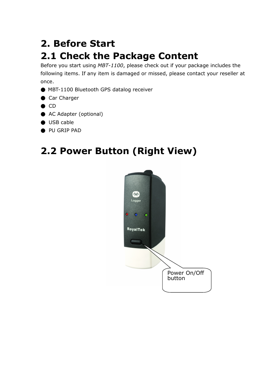
2.2 Power Button (Right View)
Power On/Off
button
�
2.3 LED Display
1
2
3
4
5
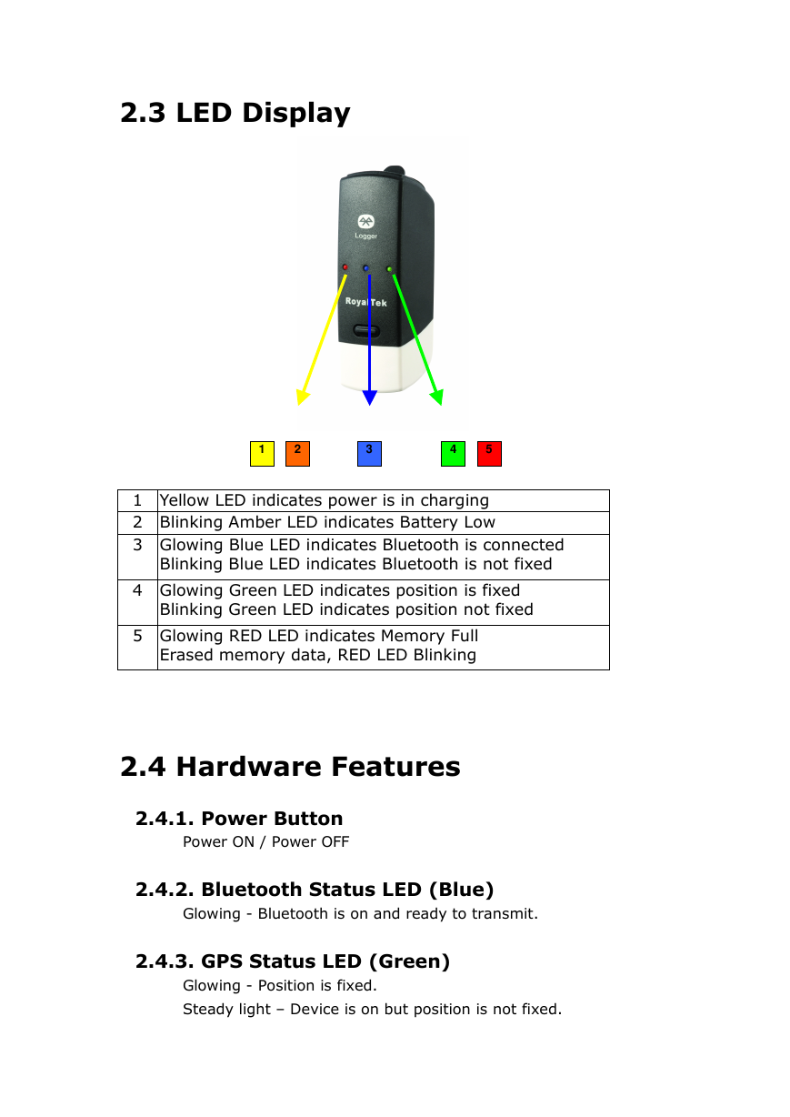
1 Yellow LED indicates power is in charging
2 Blinking Amber LED indicates Battery Low
3 Glowing Blue LED indicates Bluetooth is connected
Blinking Blue LED indicates Bluetooth is not fixed
4 Glowing Green LED indicates position is fixed
Blinking Green LED indicates position not fixed
5 Glowing RED LED indicates Memory Full
Erased memory data, RED LED Blinking
2.4 Hardware Features
2.4.1. Power Button
Power ON / Power OFF
2.4.2. Bluetooth Status LED (Blue)
Glowing - Bluetooth is on and ready to transmit.
2.4.3. GPS Status LED (Green)
Glowing - Position is fixed.
Steady light – Device is on but position is not fixed.
�
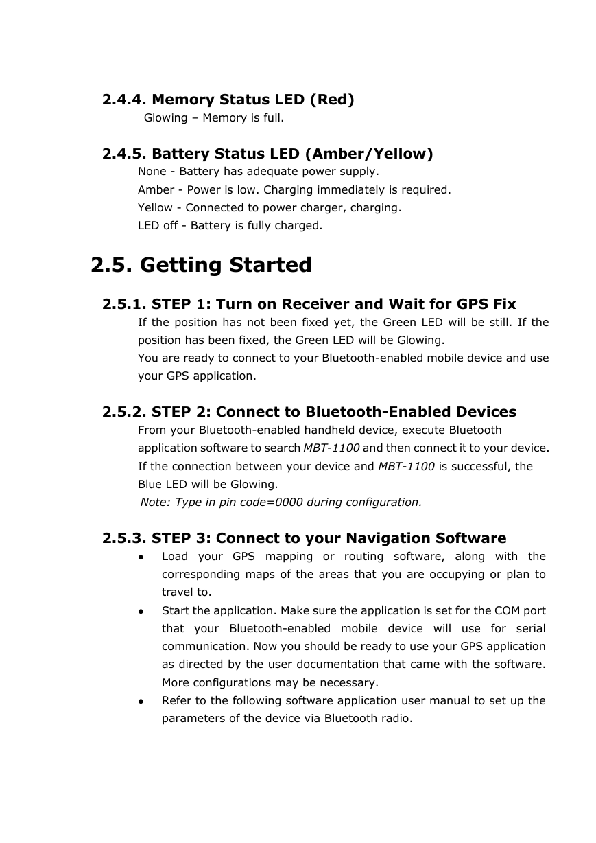
2.4.4. Memory Status LED (Red)
Glowing – Memory is full.
2.4.5. Battery Status LED (Amber/Yellow)
None - Battery has adequate power supply.
Amber - Power is low. Charging immediately is required.
Yellow - Connected to power charger, charging.
LED off - Battery is fully charged.
2.5. Getting Started
2.5.1. STEP 1: Turn on Receiver and Wait for GPS Fix
If the position has not been fixed yet, the Green LED will be still. If the
position has been fixed, the Green LED will be Glowing.
You are ready to connect to your Bluetooth-enabled mobile device and use
your GPS application.
2.5.2. STEP 2: Connect to Bluetooth-Enabled Devices
From your Bluetooth-enabled handheld device, execute Bluetooth
application software to search MBT-1100 and then connect it to your device.
If the connection between your device and MBT-1100 is successful, the
Blue LED will be Glowing.
Note: Type in pin code=0000 during configuration.
2.5.3. STEP 3: Connect to your Navigation Software
� Load your GPS mapping or routing software, along with the
corresponding maps of the areas that you are occupying or plan to
travel to.
� Start the application. Make sure the application is set for the COM port
that your Bluetooth-enabled mobile device will use for serial
communication. Now you should be ready to use your GPS application
as directed by the user documentation that came with the software.
More configurations may be necessary.
� Refer to the following software application user manual to set up the
parameters of the device via Bluetooth radio.
�


 2023年江西萍乡中考道德与法治真题及答案.doc
 2012年重庆南川中考生物真题及答案.doc
 2013年江西师范大学地理学综合及文艺理论基础考研真题.doc
 2020年四川甘孜小升初语文真题及答案I卷.doc
 2020年注册岩土工程师专业基础考试真题及答案.doc
 2023-2024学年福建省厦门市九年级上学期数学月考试题及答案.doc
 2021-2022学年辽宁省沈阳市大东区九年级上学期语文期末试题及答案.doc
 2022-2023学年北京东城区初三第一学期物理期末试卷及答案.doc
 2018上半年江西教师资格初中地理学科知识与教学能力真题及答案.doc
 2012年河北国家公务员申论考试真题及答案-省级.doc
 2020-2021学年江苏省扬州市江都区邵樊片九年级上学期数学第一次质量检测试题及答案.doc
 2022下半年黑龙江教师资格证中学综合素质真题及答案.doc