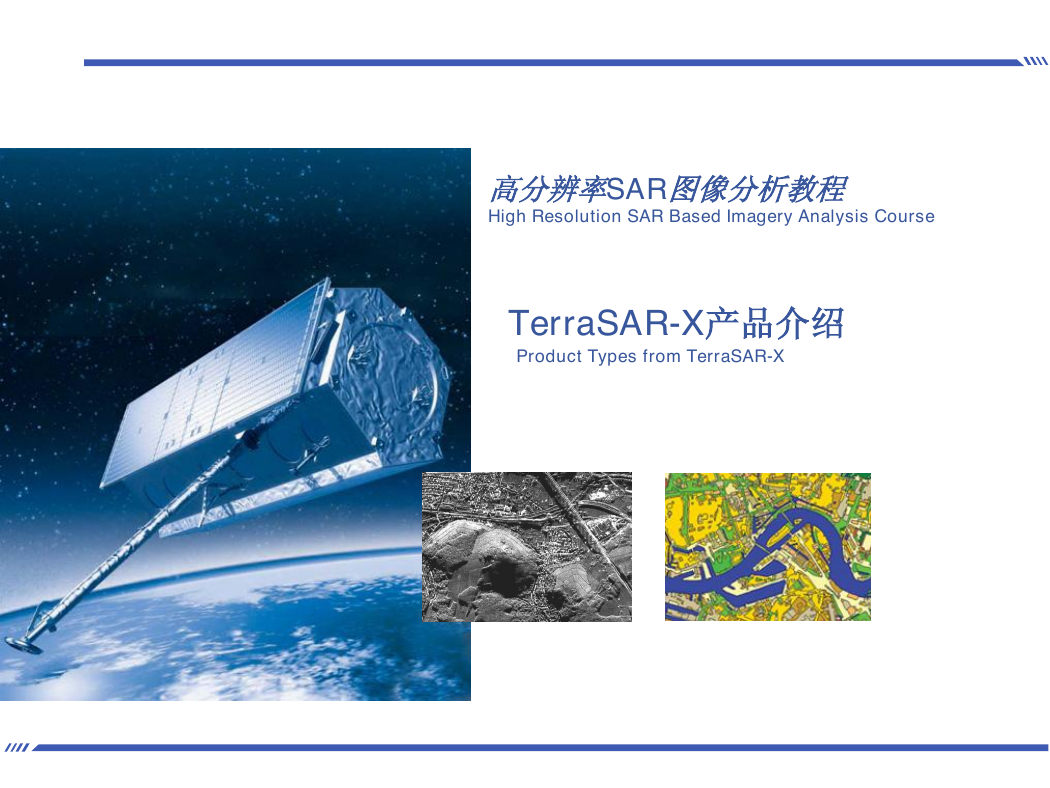
高分辨率SAR图像分析教程
High Resolution SAR Based Imagery Analysis Course
TerraSAR-X产品介绍
Product Types from TerraSAR-X
�
内容
Contents
成像模式:SpotLight,StripMap和ScanSAR模式
Imaging Modes: SpotLight , StripMap and ScanSAR Modes
TerraSAR基本产品
TerraSAR-X Basic Products
基本影像产品
Basic Image Products
增值产品:TerraSAR-X增强和地理信息产品
Value Added Products: TerraSAR-X Enhanced and Geoinformation Products
TanDEM-X的设计和发射
TanDEM-X Programme and Mission
2
�
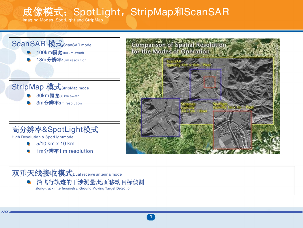
成像模式:SpotLight,StripMap和ScanSAR
Imaging Modes: SpotLight and StripMap
ScanSAR 模式ScanSAR mode
100km幅宽100 km swath
18m分辨率16 m resolution
StripMap 模式StripMap mode
30km幅宽30 km swath
3m分辨率3 m resolution
高分辨率&SpotLight模式
High Resolution & SpotLightmode
5/10 km x 10 km
1m分辨率1 m resolution
双重天线接收模式Dual receive antenna mode
沿飞行轨迹的干涉测量,地面移动目标侦测
along-track interferometry, Ground Moving Target Detection
3
�
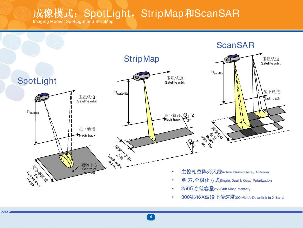
成像模式:SpotLight,StripMap和ScanSAR
Imaging Modes: SpotLight and StripMap
SpotLight
hsatellite
hsatellite
卫星轨道
Satellite orbit
星下轨迹
Nadir track
旋转中心
Centre of
rotation
ScanSAR
StripMap
卫星轨道
Satellite orbit
hsatellite
卫星轨道
Satellite orbit
星下轨迹
Nadir track
星下轨迹
Nadir track
Θ1=2
0o
Θ2=4
5o
• 主控相位阵列天线Active Phased Array Antenna
• 单,双,全极化方式Single, Dual & Quad Polarization
•
•
256G存储容量256 Gbit Mass Memory
300兆/秒X波段下传速度300 Mbit/s Downlink in X-Band
4
�
成像模式:SpotLight,StripMap和ScanSAR
Imaging Modes: SpotLight and StripMap
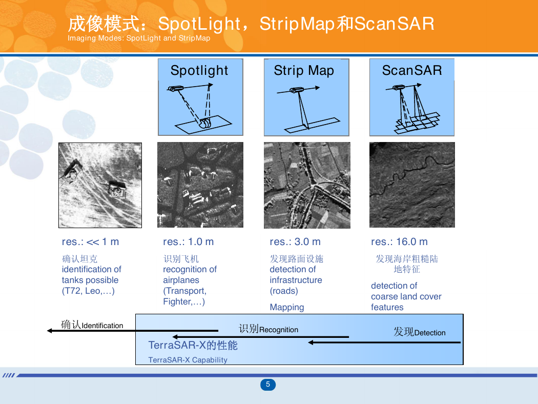
Spotlight
Strip Map
ScanSAR
res.: << 1 m
res.: 1.0 m
确认坦克
identification of
tanks possible
(T72, Leo,…)
确认Identification
识别飞机
recognition of
airplanes
(Transport,
Fighter,…)
res.: 3.0 m
发现路面设施
detection of
infrastructure
(roads)
Mapping
res.: 16.0 m
发现海岸粗糙陆
地特征
detection of
coarse land cover
features
发现Detection
TerraSAR-X的性能
TerraSAR-X Capability
识别Recognition
5
�
TerraSAR影像模式
Imaging Modes of TerraSAR-X
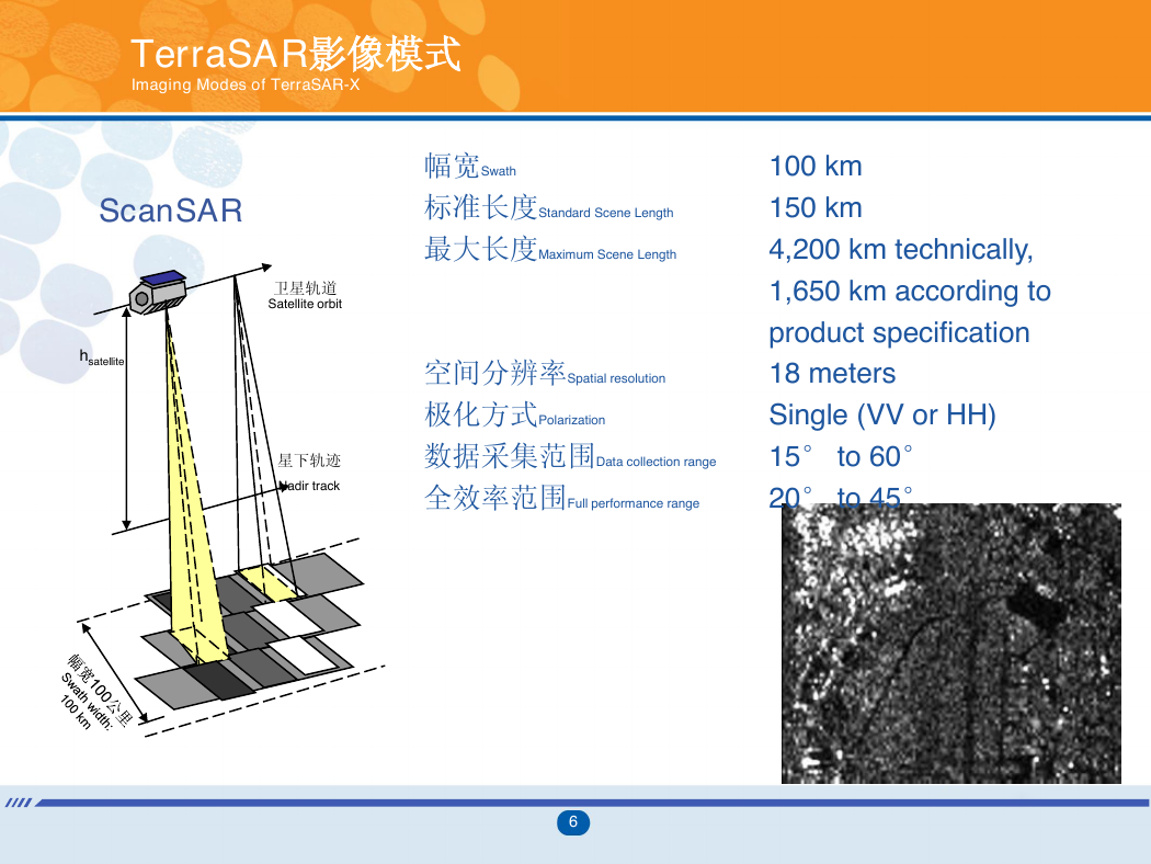
ScanSAR
hsatellite
卫星轨道
Satellite orbit
星下轨迹
Nadir track
幅宽Swath
标准长度Standard Scene Length
最大长度Maximum Scene Length
100 km
150 km
4,200 km technically,
1,650 km according to
product specification
空间分辨率Spatial resolution
极化方式Polarization
数据采集范围Data collection range
全效率范围Full performance range
18 meters
Single (VV or HH)
15° to 60°
20° to 45°
6
�
TerraSAR影像模式
Imaging Modes of TerraSAR-X
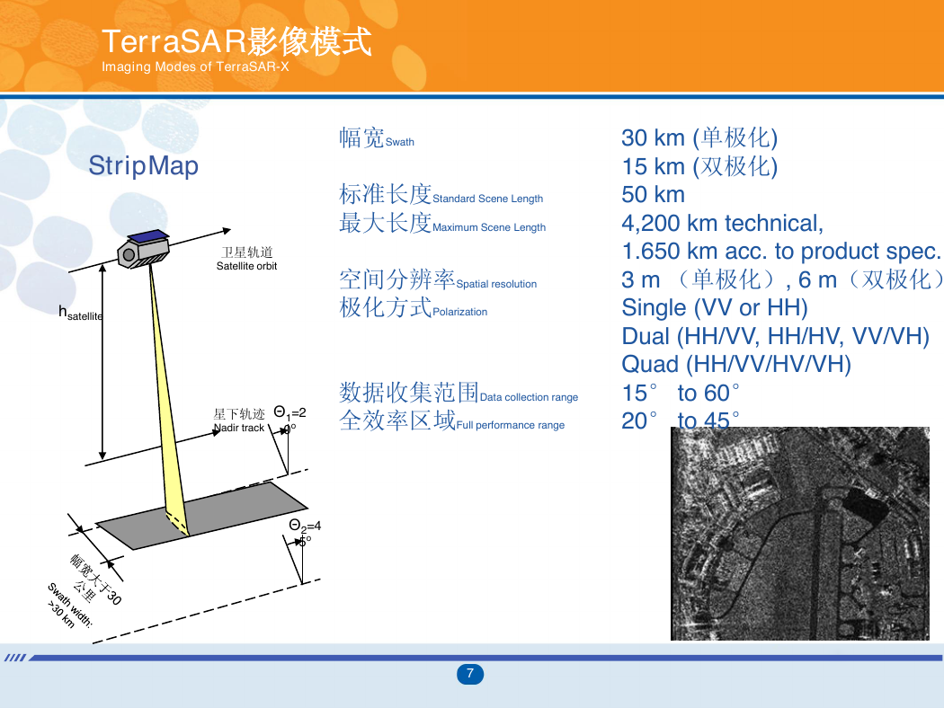
StripMap
卫星轨道
Satellite orbit
hsatellite
幅宽Swath
标准长度Standard Scene Length
最大长度Maximum Scene Length
空间分辨率Spatial resolution
极化方式Polarization
星下轨迹
Nadir track
Θ1=2
0o
数据收集范围Data collection range
全效率区域Full performance range
30 km (单极化)
15 km (双极化)
50 km
4,200 km technical,
1.650 km acc. to product spec.
3 m (单极化), 6 m(双极化)
Single (VV or HH)
Dual (HH/VV, HH/HV, VV/VH)
Quad (HH/VV/HV/VH)
15° to 60°
20° to 45°
Θ2=4
5o
7
�
TerraSAR影像模式
Imaging Modes of TerraSAR-X
像幅尺寸Scene size
空间分辨率Spatial resolution
极化方式Polarization
带宽Bandwidth
数据收集范围Data collection range
全效率范围Full performance range
取决于入射角和多极化方式
10 km x 10 km
1-4 m
单极化 (VV or HH)
双极化 (HH/VV)
150 and 300 MHz
15° to 60°
20° to 55°
高分辨率SpotLight模式 5 x 10 km
High Resolution SpotLight Mode
SpotLight
hsatellite
卫星轨道
Satellite orbit
星下轨迹
Nadir track
旋转中心
Centre of
rotation
8
�



 2023年江西萍乡中考道德与法治真题及答案.doc
 2012年重庆南川中考生物真题及答案.doc
 2013年江西师范大学地理学综合及文艺理论基础考研真题.doc
 2020年四川甘孜小升初语文真题及答案I卷.doc
 2020年注册岩土工程师专业基础考试真题及答案.doc
 2023-2024学年福建省厦门市九年级上学期数学月考试题及答案.doc
 2021-2022学年辽宁省沈阳市大东区九年级上学期语文期末试题及答案.doc
 2022-2023学年北京东城区初三第一学期物理期末试卷及答案.doc
 2018上半年江西教师资格初中地理学科知识与教学能力真题及答案.doc
 2012年河北国家公务员申论考试真题及答案-省级.doc
 2020-2021学年江苏省扬州市江都区邵樊片九年级上学期数学第一次质量检测试题及答案.doc
 2022下半年黑龙江教师资格证中学综合素质真题及答案.doc