卫星定位导航
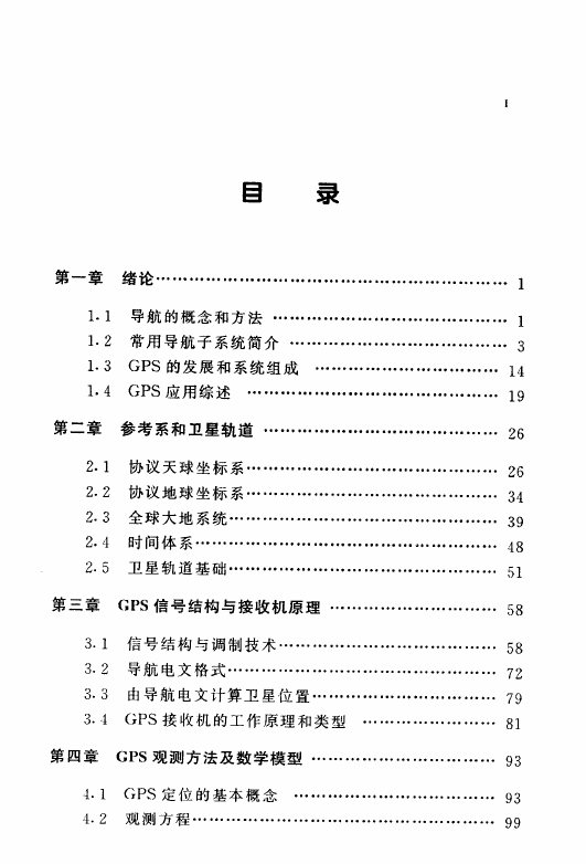
第一章 绪论
1.1 导航概念和方法
1.2常用导航子系统简介
1.2.1INS/IRS惯性导航系统
1.2.2Radar雷达
1.2.3TACAN塔康Tactical/Air Navigation
1.2.4Loran罗兰LongRangeNavigation
1.2.5 Omega
1.2.6VOR夫尔veryHigh-FrequencyOmnidirectionalRanging
1.2.7DEM测距仪DistanceMeasurementEquipment
1.2.8 VORTAC
1.2.9-JTIDS联合战术信息分布系统
1.2.10-VF目视飞越VisualFlyover
1.2.11FLIR/IDS前向红外ForwardLookingInfrared
1.2.12 TERCOM地形匹配
1.2.13SS/ST星追踪
1.3GPS发展和系统组成
1.3.1空间部分
1.3.2地面部分
1.3.3用户接收机
1.4GPS应用综述
1.4.1在民用航空中的应用
1.4.2在航天中的应用
1.4.3在航海和海洋工程中的应用
1.4.4在大地测量中的应用
1.4.5在陆地导航中的应用
1.4.6在军事上的应用
第二章 参考系和卫星轨道
2.1 协议天球坐标系
2.1.1 天球基本概念
2.1.2天球坐标系
2.1.3岁差与章动的影响
2.1.4协议天球坐标系
2.2协议地球坐标系
2.2.1地球固连坐标系
2.2.2极移与协议地球坐标系
2.2.3协议地球坐标系与协议天球坐标系间转换
2.3全球大地系统
2.3.1WGS84
2.3.2局部大地系统
2.3.3WGS84与其他大地系统关系
2.3.4高斯一克吕格坐标系
2.3.5高度关系
2.4时间体系
2.4.1世界时
2.4.2历书时
2.4.3原子时
2.4.4协调时
2.4.5GPS时
2.5卫星轨道基础
第三章GPS信号结构与接收原理
3.1 信号结构与调制技术
3.1.1信号成分
3.4.4GPS接收机工作原理
第四章 GPS观测方法及数字模型
GNSS Book.pdf
Contents
Preface xv
Acknowledgments xvii
1 Introduction 1
1.1 Introduction 1
1.2 Condensed GPS Program History 2
1.3 GPS Overview 3
1.3.1 PPS 4
1.3.2 SPS 4
1.4 GPS Modernization Program 5
1.5 GALILEO Satellite System 6
1.6 Russian GLONASS System 7
1.7 Chinese BeiDou System 8
1.8 Augmentations 10
1.9 Markets and Applications 10
1.9.1 Land 11
1.9.2 Aviation 12
1.9.3 Space Guidance 13
1.9.4 Maritime 14
1.10 Organization of the Book 14
References 19
2 Fundamentals of Satellite Navigation 21
2.1 Concept of Ranging Using TOA Measurements 21
2.1.1 Two-Dimensional Position Determination 21
2.1.2 Principle of Position Determination Via Satellite-Generated Ranging Signals 24
2.2 Reference Coordinate Systems 26
2.2.1 Earth-Centered Inertial Coordinate System 27
2.2.2 Earth-Centered Earth-Fixed Coordinate System 28
2.2.3 World Geodetic System 29
2.2.4 Height Coordinates and the Geoid 32
2.3 Fundamentals of Satellite Orbits 34
2.3.1 Orbital Mechanics 34
2.3.2 Constellation Design 43
2.4 Position Determination Using PRN Codes 50
2.4.1 Determining Satellite-to-User Range 51
2.4.2 Calculation of User Position 54
2.5 Obtaining User Velocity 58
2.6 Time and GPS 61
2.6.1 UTC Generation 61
2.6.2 GPS System Time 62
2.6.3 Receiver Computation of UTC (USNO) 62
References 63
3 GPS System Segments 67
3.1 Overview of the GPS System 67
3.1.1 Space Segment Overview 67
3.1.2 Control Segment (CS) Overview 68
3.1.3 User Segment Overview 68
3.2 Space Segment Description 68
3.2.1 GPS Satellite Constellation Description 69
3.2.2 Constellation Design Guidelines 71
3.2.3 Space Segment Phased Development 71
3.3 Control Segment 87
3.3.1 Current Configuration 88
3.3.2 CS Planned Upgrades 100
3.4 User Segment 103
3.4.1 GPS Set Characteristics 103
3.4.2 GPS Receiver Selection 109
References 110
4 GPS Satellite Signal Characteristics 113
4.1 Overview 113
4.2 Modulations for Satellite Navigation 113
4.2.1 Modulation Types 113
4.2.2 Multiplexing Techniques 115
4.2.3 Signal Models and Characteristics 116
4.3 Legacy GPS Signals 123
4.3.1 Frequencies and Modulation Format 123
4.3.2 Power Levels 133
4.3.3 Autocorrelation Functions and Power Spectral Densities 135
4.3.4 Cross-Correlation Functions and CDMA Performance 140
4.4 Navigation Message Format 142
4.5 Modernized GPS Signals 145
4.5.1 L2 Civil Signal 145
4.5.2 L5 147
4.5.3 M Code 148
4.5.4 L1 Civil Signal 150
4.6 Summary 150
References 150
5 Satellite Signal Acquisition, Tracking, and Data Demodulation 153
5.1 Overview 153
5.2 GPS Receiver Code and Carrier Tracking 155
5.2.1 Predetection Integration 158
5.2.2 Baseband Signal Processing 159
5.2.3 Digital Frequency Synthesis 161
5.2.4 Carrier Aiding of Code Loop 162
5.2.5 External Aiding 164
5.3 Carrier Tracking Loops 164
5.3.1 Phase Lock Loops 165
5.3.2 Costas Loops 166
5.3.3 Frequency Lock Loops 170
5.4 Code Tracking Loops 173
5.5 Loop Filters 179
5.6 Measurement Errors and Tracking Thresholds 183
5.6.1 PLL Tracking Loop Measurement Errors 184
5.6.2 FLL Tracking Loop Measurement Errors 192
5.6.3 C/A and P(Y) Code Tracking Loop Measurement Errors 194
5.6.4 Modernized GPS M Code Tracking Loop Measurement Errors 199
5.7 Formation of Pseudorange, Delta Pseudorange, and Integrated Doppler 200
5.7.1 Pseudorange 201
5.7.2 Delta Pseudorange 216
5.7.3 Integrated Doppler 218
5.8 Signal Acquisition 219
5.8.1 Tong Search Detector 223
5.8.2 M of N Search Detector 227
5.8.3 Direct Acquisition of GPS Military Signals 229
5.9 Sequence of Initial Receiver Operations 231
5.10 Data Demodulation 232
5.11 Special Baseband Functions 233
5.11.1 Signal-to-Noise Power Ratio Meter 233
5.11.2 Phase Lock Detector with Optimistic and Pessimistic Decisions 233
5.11.3 False Frequency Lock and False Phase Lock Detector 235
5.12 Use of Digital Processing 235
5.13 Considerations for Indoor Applications 237
5.14 Codeless and Semicodeless Processing 239
References 240
6 Interference, Multipath, and Scintillation 243
6.1 Overview 243
6.2 Radio Frequency Interference 243
6.2.1 Types and Sources of RF Interference 244
6.2.2 Effects of RF Interference on Receiver Performance 247
6.2.3 Interference Mitigation 278
6.3 Multipath 279
6.3.1 Multipath Characteristics and Models 281
6.3.2 Effects of Multipath on Receiver Performance 285
6.3.3 Multipath Mitigation 292
6.4 Ionospheric Scintillation 295
References 297
7 Performance of Stand-Alone GPS 301
7.1 Introduction 301
7.2 Measurement Errors 302
7.2.1 Satellite Clock Error 304
7.2.2 Ephemeris Error 305
7.2.3 Relativistic Effects 306
7.2.4 Atmospheric Effects 308
7.2.5 Receiver Noise and Resolution 319
7.2.6 Multipath and Shadowing Effects 319
7.2.7 Hardware Bias Errors 320
7.2.8 Pseudorange Error Budgets 321
7.3 PVT Estimation Concepts 322
7.3.1 Satellite Geometry and Dilution of Precision in GPS 322
7.3.2 Accuracy Metrics 328
7.3.3 Weighted Least Squares (WLS) 332
7.3.4 Additional State Variables 333
7.3.5 Kalman Filtering 334
7.4 GPS Availability 334
7.4.1 Predicted GPS Availability Using the Nominal 24-Satellite GPS Constellation 335
7.4.2 Effects of Satellite Outages on GPS Availability 337
7.5 GPS Integrity 343
7.5.1 Discussion of Criticality 345
7.5.2 Sources of Integrity Anomalies 345
7.5.3 Integrity Enhancement Techniques 346
7.6 Continuity 360
7.7 Measured Performance 361
References 375
8 Differential GPS 379
8.2 Spatial and Time Correlation Characteristics of GPS Errors 381
8.2.1 Satellite Clock Errors 381
8.2.2 Ephemeris Errors 382
8.2.3 Tropospheric Errors 384
8.2.4 Ionospheric Errors 387
8.2.5 Receiver Noise and Multipath 390
8.3 Code-Based Techniques 391
8.3.1 Local-Area DGPS 391
8.3.2 Regional-Area DGPS 394
8.3.3 Wide-Area DGPS 395
8.4 Carrier-Based Techniques 397
8.4.1 Precise Baseline Determination in Real Time 398
8.4.2 Static Application 418
8.4.3 Airborne Application 420
8.4.4 Attitude Determination 423
8.5 Message Formats 425
8.5.1 Version 2.3 425
8.5.2 Version 3.0 428
8.6 Examples 429
8.6.2 Carrier Based 450
References 454
9 Integration of GPS with Other Sensors and Network Assistance 459
9.1 Overview 459
9.2 GPS/Inertial Integration 460
9.2.1 GPS Receiver Performance Issues 460
9.2.2 Inertial Sensor Performance Issues 464
9.2.3 The Kalman Filter 466
9.2.4 GPSI Integration Methods 470
9.2.5 Reliability and Integrity 488
9.2.6 Integration with CRPA 489
9.3 Sensor Integration in Land Vehicle Systems 491
9.3.1 Introduction 491
9.3.2 Review of Available Sensor Technology 496
9.3.3 Sensor Integration Principles 515
9.4 Network Assistance 522
9.4.1 Historical Perspective of Assisted GPS 526
9.4.2 Requirements of the FCC Mandate 528
9.4.3 Total Uncertainty Search Space 535
9.4.4 GPS Receiver Integration in Cellular Phones—Assistance Data from Handsets 540
9.4.5 Types of Network Assistance 543
References 554
10 GALILEO 559
10.1 GALILEO Program Objectives 559
10.2 GALILEO Services and Performance 559
10.2.1 Open Service (OS) 560
10.2.2 Commercial Service (CS) 562
10.2.3 Safety of Life (SOL) Service 562
10.2.4 Public Regulated Service (PRS) 562
10.2.5 Support to Search and Rescue (SAR) Service 563
10.3 GALILEO Frequency Plan and Signal Design 563
10.3.1 Frequencies and Signals 563
10.3.2 Modulation Schemes 565
10.3.3 SAR Signal Plan 576
10.4 Interoperability Between GPS and GALILEO 577
10.4.1 Signal in Space 577
10.4.2 Geodetic Coordinate Reference Frame 578
10.4.3 Time Reference Frame 578
10.5 System Architecture 579
10.5.1 Space Segment 581
10.5.2 Ground Segment 585
10.6 GALILEO SAR Architecture 591
10.7 GALILEO Development Plan 592
References 594
11 Other Satellite Navigation Systems 595
11.1 The Russian GLONASS System 595
11.1.1 Introduction 595
11.1.2 Program Overview 595
11.1.3 Organizational Structure 597
11.1.4 Constellation and Orbit 597
11.1.5 Spacecraft Description 599
11.1.6 Ground Support 602
11.1.7 User Equipment 604
11.1.8 Reference Systems 605
11.1.9 GLONASS Signal Characteristics 606
11.1.10 System Accuracy 611
11.1.11 Future GLONASS Development 612
11.1.12 Other GLONASS Information Sources 614
11.2 The Chinese BeiDou Satellite Navigation System 615
11.2.1 Introduction 615
11.2.3 Program History 616
11.2.4 Organization Structure 617
11.2.5 Constellation and Orbit 617
11.2.6 Spacecraft 617
11.2.7 RDSS Service Infrastructure 618
11.2.8 RDSS Navigation Services 621
11.2.9 RDSS Navigation Signals 622
11.2.10 System Coverage and Accuracy 623
11.2.11 Future Developments 623
11.3 The Japanese QZSS Program 625
11.3.1 Introduction 625
11.3.2 Program Overview 625
11.3.3 Organizational Structure 626
11.3.4 Constellation and Orbit 626
11.3.5 Spacecraft Development 627
11.3.6 Ground Support 628
11.3.7 User Equipment 628
11.3.8 Reference Systems 628
11.3.9 Navigation Services and Signals 628
11.3.10 System Coverage and Accuracy 629
11.3.11 Future Development 629
Acknowledgments 630
References 630
12 GNSS Markets and Applications 635
12.1 GNSS: A Complex Market Based on Enabling Technologies 635
12.1.1 Market Scope, Segmentation, and Value 638
12.1.2 Unique Aspects of GNSS Market 639
12.1.3 Market Limitations, Competitive Systems, and Policy 640
12.2 Civil Navigation Applications of GNSS 641
12.2.1 Marine Navigation 642
12.2.2 Air Navigation 645
12.2.3 Land Navigation 646
12.3 GNSS in Surveying, Mapping, and Geographical Information Systems 647
12.3.1 Surveying 648
12.3.2 Mapping 648
12.3.3 GIS 649
12.4 Recreational Markets for GNSS-Based Products 650
12.5 GNSS Time Transfer 650
12.6 Differential Applications and Services 650
12.6.1 Precision Approach Aircraft Landing Systems 651
12.6.2 Other Differential Systems 651
12.6.3 Attitude Determination Systems 652
12.7 GNSS and Telematics and LBS 652
12.8 Creative Uses for GNSS 654
12.9 Government and Military Applications 654
12.9.1 Military User Equipment—Aviation, Shipboard, and Land 655
12.9.2 Autonomous Receivers—Smart Weapons 656
12.9.3 Space Applications 657
12.9.4 Other Government Applications 657
12.10 User Equipment Needs for Specific Markets 657
12.11 Financial Projections for the GNSS Industry 660
References 661
Appendix A:Least Squares and Weighted Least Squares Estimates 663
Reference 664
Appendix B:Stability Measures for Frequency Sources 665
B.1 Introduction 665
B.2 Frequency Standard Stability 665
B.3 Measures of Stability 667
B.3.1 Allan Variance 667
B.3.2 Hadamard Variance 667
References 668
Appendix C:Free-Space Propagation Loss 669
C.1 Introduction 669
C.2 Free-Space Propagation Loss 669
C.3 Conversion Between PSDs and PFDs 673
References 673
About the Authors 675
Index 683
Mobile Communications Library
fundermential of GPS receivers.pdf
Fundamentals of GPS Receivers
sat-position
Preface
Contents
Part I:
ch1
ch2
ch3
Chapter 4Solving for SV Position
Part II:
Part III:
Appendix A Sliding Correlators, Delay-Based Discriminators, and Processing Gain with GPS Applications
Appendix B Pseudo-Random Binary Codes and the C/A Code Generator
Appendix C BPSK Modulators and Demodulators
Appendix D Subframe Format
Appendix E
Glossary
Index



 2023年江西萍乡中考道德与法治真题及答案.doc
 2012年重庆南川中考生物真题及答案.doc
 2013年江西师范大学地理学综合及文艺理论基础考研真题.doc
 2020年四川甘孜小升初语文真题及答案I卷.doc
 2020年注册岩土工程师专业基础考试真题及答案.doc
 2023-2024学年福建省厦门市九年级上学期数学月考试题及答案.doc
 2021-2022学年辽宁省沈阳市大东区九年级上学期语文期末试题及答案.doc
 2022-2023学年北京东城区初三第一学期物理期末试卷及答案.doc
 2018上半年江西教师资格初中地理学科知识与教学能力真题及答案.doc
 2012年河北国家公务员申论考试真题及答案-省级.doc
 2020-2021学年江苏省扬州市江都区邵樊片九年级上学期数学第一次质量检测试题及答案.doc
 2022下半年黑龙江教师资格证中学综合素质真题及答案.doc