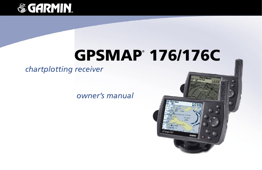
GPSMAP® 176/176C
chartplotting receiver
owner’s manual
�
© Copyright 2002-2005 Garmin Ltd. or its subsidiaries
Garmin International, Inc.
1200 East 151st Street,
Olathe, Kansas 66062, U.S.A.
Tel. 913/397.8200 or 800/800.1020
Fax 913/397.8282
Garmin (Europe) Ltd.
Unit 5, The Quadrangle,
Abbey Park Industrial Estate,
Romsey, SO51 9DL, U.K.
Tel. 44/0870.8501241
Fax 44/0870.8501251
Garmin Corporation
No. 68, Jangshu 2nd Road, Shijr,
Taipei County, Taiwan
Tel. 886/2.2642.9199
Fax 886/2.2642.9099
All rights reserved. Except as expressly provided herein, no part of this manual may be reproduced, copied, transmitted, disseminated, downloaded or stored in any
storage medium, for any purpose without the express prior written consent of Garmin. Garmin hereby grants permission to download a single copy of this manual onto
a hard drive or other electronic storage medium to be viewed and to print one copy of this manual or of any revision hereto, provided that such electronic or printed
copy of this manual must contain the complete text of this copyright notice and provided further that any unauthorized commercial distribution of this manual or any
revision hereto is strictly prohibited.
Information in this document is subject to change without notice. Garmin reserves the right to change or improve its products and to make changes in the content
without obligation to notify any person or organization of such changes or improvements. Visit the Garmin Web site (www.garmin.com) for current updates and
supplemental information concerning the use and operation of this and other Garmin products.
Garmin®, GPSMAP®, AutoLocate®, TracBack®, BlueChart®, and MapSource® are registered trademarks of Garmin Ltd. or its subsidiaries and may not be used without
the express permission of Garmin.
January 2005
Part Number 190-00185-10 Rev. C
Printed in Taiwan
�
INTRODUCTION > ABOUT THIS MANUAL
The Main Pages chapter provides detailed explanations about each
page in the GPSMAP 176/176C and step-by-step directions on using
the pages. The Main Menu chapter provides detailed explanations
about the Main Menu and how to use it to configure your unit.
The Appendix contains information such as specifications, optional
accessories, and maintenance information. You can also find warranty
and FCC information in the Appendix. Read the Safety Information
to learn how to install and use your Garmin GPSMAP 176/176C
safely and responsibly. An Index is provided at the end of the
manual for reference. Simply look up the topic you wish to learn
about and read the page or pages listed.
INTRODUCTION
Thank you for choosing the Garmin® GPSMAP® 176/176C. The
GPSMAP 176/176C utilizes the proven performance of Garmin GPS
and full-featured mapping to create an unsurpassed portable GPS
receiver. Please take a moment now to compare the contents of this
package with the packing list on the outside of the box. If any pieces
are missing, contact your Garmin dealer immediately.
About This Manual
To get the most out of your new navigation system, take time to read
this manual and learn the operating procedures for your unit in detail.
This manual is organized into the following chapters.
The Introduction chapter contains the Table of Contents as well as
GPSMAP 176/176C care information.
The Getting Started chapter provides information such as an overview
of unit features to help you get acquainted with your new GPSMAP
176/176C.
The Basic Operation chapter provides you with information about
features such as using the Find Menu, navigating a route, and using
waypoints. There are also step-by-step directions to assist you in
these operations.
GPSMAP 176/176C Owner’s Manual
i
�
Immersing the Unit in Water
The GPSMAP 176/176C is waterproof to IEC Standard 60529
IPX7. It can withstand immersion in 1 meter of water for 30
minutes. Prolonged submersion can cause damage to the unit. After
submersion, be certain to wipe and air dry the unit before reuse.
To resolve problems that cannot be remedied using this guide, contact
Garmin Product Support in the U.S. at 800/800.1020 or Garmin
Europe at 44/0870.8501241.
INTRODUCTION > CARE INFORMATION
Care Information
Cleaning the Unit
The GPSMAP 176/176C is constructed of high quality materials and
does not require user maintenance other than cleaning. Clean the unit
using a cloth dampened with a mild detergent solution and then wipe
dry. Avoid chemical cleaners and solvents that may damage plastic
components.
WARNING: The GPSMAP 176/176C lens is coated with a special
anti-reflective coating which is very sensitive to skin oils, waxes,
and abrasive cleaners. CLEANERS CONTAINING AMMONIA
HARM THE ANTI-REFLECTIVE COATING. It is very important
to clean the lens using an eyeglass lens cleaner that is specified as
safe for anti-reflective coatings and a clean, lint-free cloth.
Storing the GPSMAP 176/176C
Do not store the GPSMAP 176/176C where prolonged exposure to
temperature extremes may occur (such as in the trunk of a car) as
permanent damage may result. User information, such as waypoints
and routes are retained in the unit’s memory without the need for
external power. It is always a good practice to back up important user
data by manually recording it or downloading it to a PC (transferring
it to MapSource).
ii
GPSMAP 176/176C Owner’s Manual
�
Table of Contents
Introduction ...........................................................................i
About This Manual ................................................................... i
Care Information ...................................................................... ii
Getting Started .....................................................................3
Unit Basics ............................................................................... 3
Interface Keys .......................................................................... 6
Basic Operation ...................................................................7
Initializing the GPS Receiver .................................................. 7
Using the Map Pointer ............................................................ 9
Selecting Map Zoom Ranges ............................................... 11
Creating and Using Waypoints ............................................ 12
Marking Your Present Location ....................................................12
Creating Waypoints Graphically ...................................................13
Entering Coordinates ....................................................................14
Projecting Waypoints ....................................................................15
Waypoint Menu Options ...............................................................16
Reviewing and Editing Waypoints ...............................................17
Waypoint Lists ..............................................................................19
User Waypoint List .................................................................20
User Waypoints List Options ..................................................21
Proximity Waypoint List .........................................................22
Recent Waypoint List ..............................................................23
INTRODUCTION > TABLE OF CONTENTS
Going to a Destination .......................................................... 24
Selecting a Go To Graphically ......................................................25
TracBack Navigation (Navigating a Track) ..................................26
MOB .............................................................................................28
Creating a Route .................................................................... 29
Following a Route ........................................................................31
Route List Page .............................................................................32
Route Review Page .......................................................................33
Route Review Menu Options .......................................................35
Active Route Page ........................................................................39
Find ......................................................................................... 39
Main Pages .........................................................................41
Map Page ................................................................................ 41
Compass Page ....................................................................... 45
Highway Page ........................................................................ 46
Active Route Page ................................................................. 48
Numbers Page ....................................................................... 48
Main Menu Page ................................................................49
GPS Tab .................................................................................. 50
Trip Tab ................................................................................... 54
Route Tab ............................................................................... 54
Points Tab .............................................................................. 54
Track Tab ................................................................................ 55
Alarm Tab ............................................................................... 57
GPSMAP 176/176C Owner’s Manual
1
�
INTRODUCTION > TABLE OF CONTENTS
Celestial (Celes) Tab ............................................................. 58
Tide Tab ........................................................................................58
Sun & Moon Tab ..........................................................................61
Hunt & Fish Tab ...........................................................................62
Map Tab .................................................................................. 63
General Tab ...................................................................................63
Map Tab ........................................................................................63
Waypoint Tab ................................................................................64
Point Tab .......................................................................................64
Marine Tab ....................................................................................64
Navaids Tab ..................................................................................65
Line Tab ........................................................................................65
Track Tab ......................................................................................66
Area Tab ........................................................................................66
Topo Tab .......................................................................................66
City Tab ........................................................................................67
Road Tab .......................................................................................67
Other Tab ......................................................................................68
Setup Map Menu Options .............................................................68
Setup Tab ............................................................................... 69
System Tab ....................................................................................69
Time Tab .......................................................................................70
Units Tab .......................................................................................71
Location Tab .................................................................................71
Interface Tab .................................................................................74
Appendix ............................................................................78
Specifications ........................................................................ 78
Connecting the Power/Data .................................................. 79
Interfacing .............................................................................. 79
Satellite Information .............................................................. 80
What is WAAS? ...................................................................... 81
What is Differential GPS (DGPS)? ....................................... 81
Map Datums ........................................................................... 82
Navigation Terms .................................................................. 84
Messages ............................................................................... 86
LORAN TD System ................................................................ 88
Optional Accessories ............................................................ 90
Software License Agreement ............................................... 91
Product Registration ............................................................. 91
Limited Warranty ................................................................... 92
FCC Compliance .................................................................... 93
Safety Information ................................................................. 94
Index ...................................................................................95
2
GPSMAP 176/176C Owner’s Manual
�
GETTING STARTED > UNIT BASICS
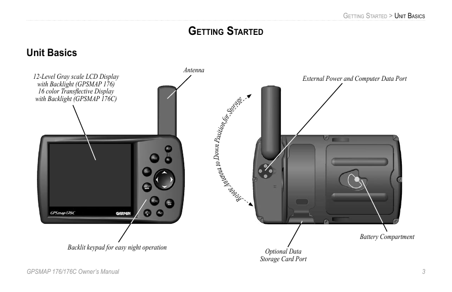
External Power and Computer Data Port
Unit Basics
12-Level Gray scale LCD Display
with Backlight (GPSMAP 176)
16 color Transflective Display
with Backlight (GPSMAP 176C)
GETTING STARTED
Antenna
sition for Storage
o
P
n
w
o
D
o
t
a
n
n
e
t
n
otate A
R
Backlit keypad for easy night operation
GPSMAP 176/176C Owner’s Manual
Optional Data
Storage Card Port
Battery Compartment
3
�
GETTING STARTED > UNIT BASICS
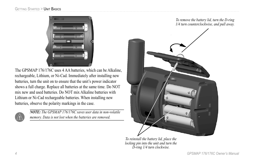
To remove the battery lid, turn the D-ring
1/4 turn counterclockwise, and pull away.
The GPSMAP 176/176C uses 4 AA batteries, which can be Alkaline,
rechargeable, Lithium, or Ni-Cad. Immediately after installing new
batteries, turn the unit on to ensure that the unit’s power indicator
shows a full charge. Replace all batteries at the same time. Do NOT
mix new and used batteries. Do NOT mix Alkaline batteries with
Lithium or Ni-Cad rechargeable batteries. When installing new
batteries, observe the polarity markings in the case.
NOTE: The GPSMAP 176/176C saves user data in non-volatile
memory. Data is not lost when the batteries are removed.
4
GPSMAP 176/176C Owner’s Manual
To reinstall the battery lid, place the
locking pin into the unit and turn the
D-ring 1/4 turn clockwise.
�


 2023年江西萍乡中考道德与法治真题及答案.doc
 2012年重庆南川中考生物真题及答案.doc
 2013年江西师范大学地理学综合及文艺理论基础考研真题.doc
 2020年四川甘孜小升初语文真题及答案I卷.doc
 2020年注册岩土工程师专业基础考试真题及答案.doc
 2023-2024学年福建省厦门市九年级上学期数学月考试题及答案.doc
 2021-2022学年辽宁省沈阳市大东区九年级上学期语文期末试题及答案.doc
 2022-2023学年北京东城区初三第一学期物理期末试卷及答案.doc
 2018上半年江西教师资格初中地理学科知识与教学能力真题及答案.doc
 2012年河北国家公务员申论考试真题及答案-省级.doc
 2020-2021学年江苏省扬州市江都区邵樊片九年级上学期数学第一次质量检测试题及答案.doc
 2022下半年黑龙江教师资格证中学综合素质真题及答案.doc