175 Manual 7/31/98 3:55 PM Page 1
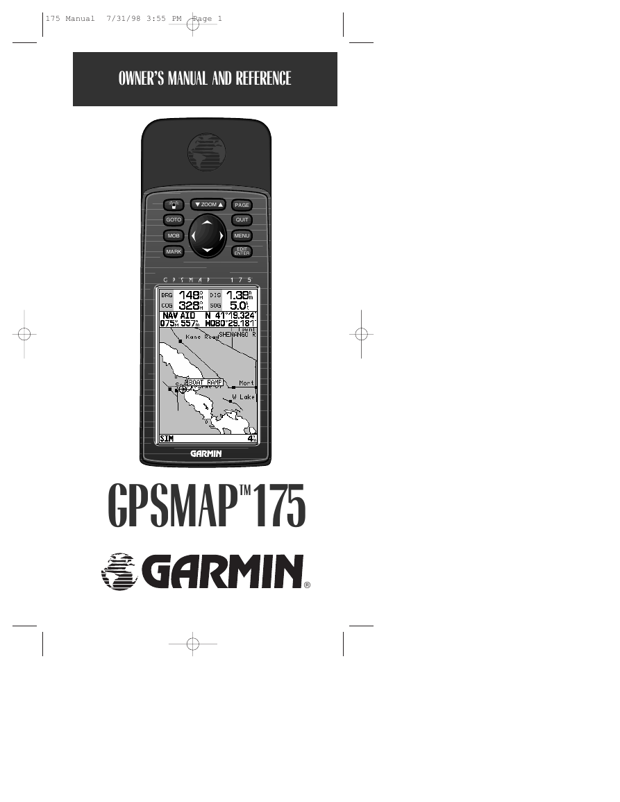
OWNERS MANUAL AND REFERENCE
1
ZOOM
PAGE
QUIT
MENU
EDIT
ENTER
GOTO
MOB
MARK
GPSMAPTM175
®
�
175 Manual 7/31/98 3:55 PM Page 2
Software Version 2.0 or above
Internal Database Version 2.01 © Navionics Corporation
G-chart cartridge data is copyrighted by Navionics Corporation and may not be
copied or used for any other purpose without permission.
© 1996 GARMIN Corporation
1200 E. 151st Street, Olathe, KS 66062, USA
GARMIN (Europe) LTD
Unit 5, The Quadrangle, Abbey Park Industrial Estate, Romsey, SO51 9AQ UK
All rights reserved. No part of this manual may be reproduced or transmitted
in any form or by any means, electronic or manual, including photocopying and
recording, for any purpose without the express written permission of GARMIN.
GARMIN, GPSMAP, G-chart, AutoLocate, TracBack, and PhaseTrac12 are
registered trademarks of GARMIN Corporation and may only be used with
permission. All rights are reserved.
Information in this document is subject to change without notice. GARMIN
reserves the right to change or improve its products and to make changes in the
content without obligation to notify any person or organization of such changes
or improvements.
September 1996
Part #190-00096-00 Rev. A Printed in Taiwan.
�
175 Manual 7/31/98 3:55 PM Page i
INTRODUCTION
Capabilities/Packing List
1
Before installing and getting started with your unit, please check to see that
your package includes the following items. If any parts are missing, please see
your GARMIN dealer immediately.
Standard Package:
• GPSMAP 175 Unit
• Owner’s Manual
• Quick Reference Card
Optional Accessories:
• G-Chart Electronic Chart Cartridges
• External Antenna and 30’ Cable
• Power/Data Cable
• Mounting Bracket
• PCmate PC-Kit
Congratulations on choosing one of the most advanced marine navigation
systems available! The GARMIN GPSMAP 175 uses the proven performance
and simple operation of GARMIN GPS in combination with powerful G-Chart
electronic charting for detailed cartography and plotting that will help guide
you in waterways around the world:
Precision Performance
• High-contrast LCD screen
• PhaseTrac12 receiver tracks and uses up to 12 satellites simultaneously for
fast, accurate positioning
• Differential-Ready— just add the optional GBR 21 beacon receiver for better
than 10 meter accuracy
• Fully-gasketed, dry nitrogen-filled case for use in exposed locations
Advanced Navigating and Plotting
• 250 alphanumeric waypoints with selectable icons and comments
• Built-in worldwide database usable from 4096 to 64 nm scales
• 20 reversible routes with up to 30 waypoints each
• G-chart electronic charting with inland and offshore coverage
• On-screen point-to-point distance and bearing calculations
• TracBack route feature which allows you to quickly retrace your track log to
a starting position
• Built-in simulator mode
i
�
175 Manual 7/31/98 3:55 PM Page ii
2
INTRODUCTION
Warning and Caution
WARNING!
The electronic chart is an aid to navigation and is designed to facilitate the use of
authorized government charts, not replace them. Only official government charts and
notices to mariners contain all information needed for the safety of navigation–and,
as always, the user is responsible for their prudent use.
CAUTION
The GPS system is operated by the United States government, which is solely
responsible for its accuracy and maintenance. The system is subject to changes
which could affect the accuracy and performance of all GPS equipment. Although
the GARMIN GPSMAP 175 is a precision electronic NAVigation AID (NAVAID),
any NAVAID can be misused or misinterpreted and, therefore, become unsafe.
Use the GPSMAP 175 at your own risk. To reduce the risk of unsafe operation,
carefully review and understand all aspects of this Owner’s Manual—and
thoroughly practice operation using the simulator mode prior to actual use. When
in actual use, carefully compare indications from the GPSMAP 175 to all available
navigation sources, including the information from other NAVAIDs, visual
sightings, charts, etc. For safety, always resolve any discrepancies before
continuing navigation.
NOTE: This equipment generates, uses and can radiate radio frequency energy
and, if not installed and used in accordance with the instructions, may cause
harmful interference to radio communications. However, there is no guarantee
that interference will not occur in a particular installation. If this equipment does
cause harmful interference, the user is encouraged to try to correct the interference
by relocating the equipment or connecting the equipment to a different circuit.
Consult an authorized dealer or other qualified technician for additional help if
these remedies do not correct the problem.
This device complies with part 15 of the FCC limits for class B digital devices.
Operation is subject to the following conditions: (1) This device may not cause
harmful interference, and (2) this device must accept any interference received,
including interference that may cause undesired operation.
The GPSMAP 175 contains no user-serviceable parts. Repairs should only be
made by an authorized service center. Unauthorized repairs or modifications
could void your warranty and your authority to operate this device under Part 15
regulations.
ii
�
175 Manual 7/31/98 3:55 PM Page 1
GETTING STARTED
Table of Contents
1
Capabilities/Packing List .................................................................i
Warning and Caution......................................................................ii
Table of Contents/Appendices .....................................................1-2
Unit Features...................................................................................3
Keypad Usage ..................................................................................4
Initializing the Receiver/Getting Started ...................................5-22
Section 1: GPSMAP Status Page..............................................23-25
Satellite status page description, receiver status, and initialization options
Section 2: Position Page ..........................................................26-27
Position page description and uses
Section 3: Map Page.................................................................28-35
Map page description, modes, scales, and options
Section 4: Navigation Page ......................................................36-38
Navigation page description and options
Section 5: Main Menu Page...........................................................39
Viewing the main menu page and selecting submenus
Section 6: Waypoints ...............................................................40-48
Creating, using, and editing waypoints
Section 7: GOTO/MOB/TracBack Functions...........................49-52
Going to a destination and using GOTO options/TracBack routes
Section 8: Routes .....................................................................53-60
Creating, editing, and using routes
Section 9: Setup Menus...........................................................61-70
System and navigation setup; timers, alarms, and track log
Section 10: Using G-chart cartridges ......................................71-72
Inserting, removing, and using electronic chart cartridges
1
�
175 Manual 7/31/98 3:55 PM Page 2
2
GETTING STARTED
Appendices
APPENDICES
Appendix A:
GPSMAP 175 Installation . . . . . . . . . . . . . . . . . . . . . . . . . . . .73-75
Appendix B:
Wiring & Specifications . . . . . . . . . . . . . . . . . . . . . . . . . . . . .76-79
Appendix C:
Messages . . . . . . . . . . . . . . . . . . . . . . . . . . . . . . . . . . . . . . . .80-81
Appendix D:
Definitions . . . . . . . . . . . . . . . . . . . . . . . . . . . . . . . . . . . . . . . . .82
Appendix E:
Time Offsets . . . . . . . . . . . . . . . . . . . . . . . . . . . . . . . . . . . . . . . .83
Appendix F:
Map Datums . . . . . . . . . . . . . . . . . . . . . . . . . . . . . . . . . . . . .84-88
Appendix G:
Index . . . . . . . . . . . . . . . . . . . . . . . . . . . . . . . . . . . . . . . . . . .89-91
2
�
175 Manual 7/31/98 3:55 PM Page 3
GETTING STARTED
1
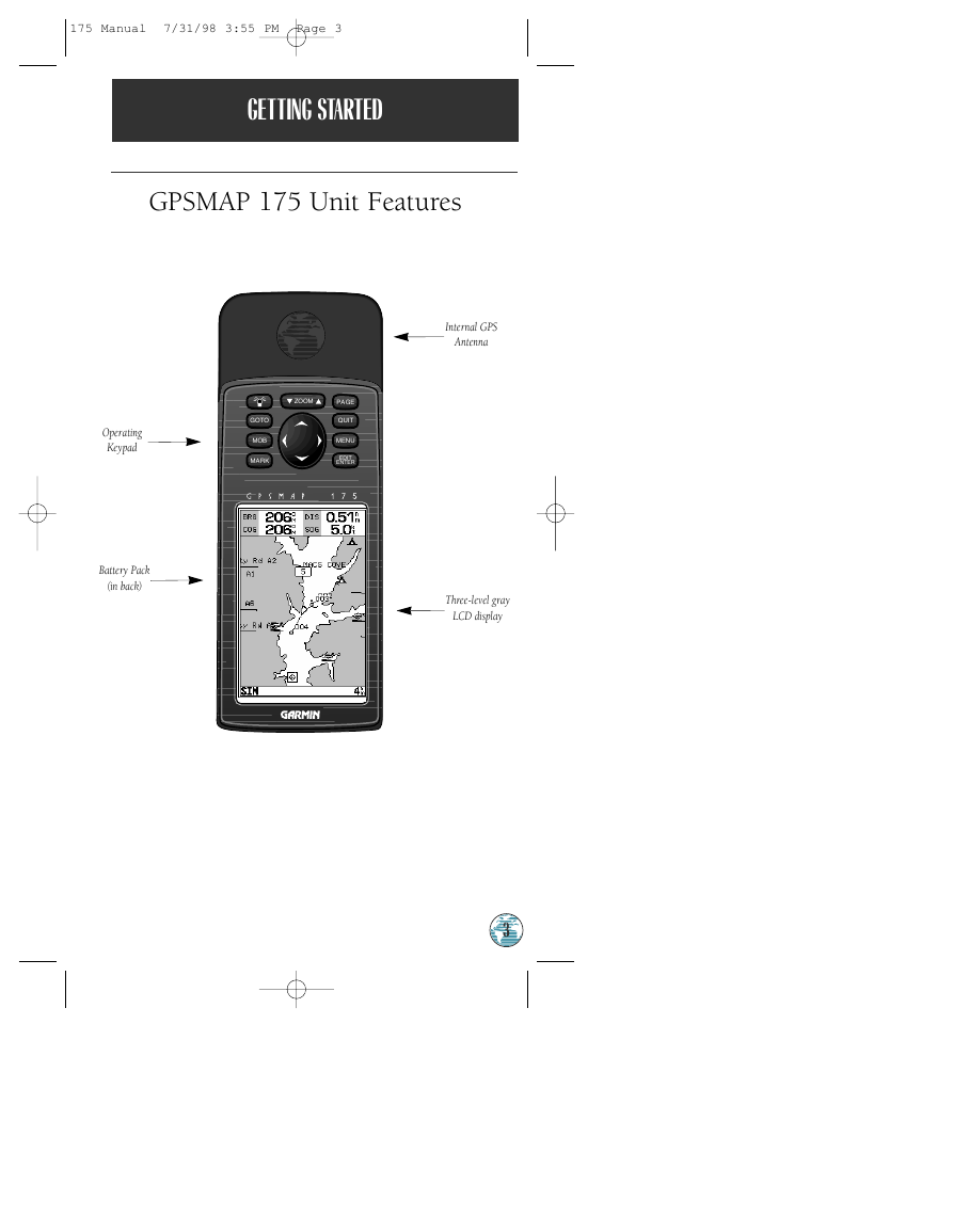
GPSMAP 175 Unit Features
ZOOM
PAGE
QUIT
MENU
EDIT
ENTER
GOTO
MOB
MARK
Operating
Keypad
Battery Pack
(in back)
Internal GPS
Antenna
Three-level gray
LCD display
3
�
175 Manual 7/31/98 3:55 PM Page 4
2
INTRODUCTION
Keypad Usage
P
J
M
G
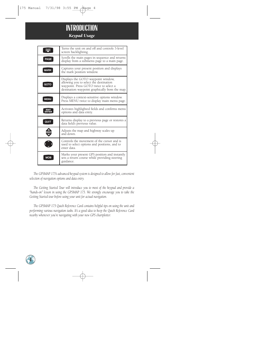
Turns the unit on and off and controls 3-level
screen backlighting.
Scrolls the main pages in sequence and returns
display from a submenu page to a main page.
Captures your present position and displays
the mark position window.
Displays the GOTO waypoint window,
allowing you to select the destination
waypoint. Press GOTO twice to select a
destination waypoint graphically from the map.
O
Displays a context-sensitive options window.
Press MENU twice to display main menu page.
T
Q
Z
R
B
Activates highlighted fields and confirms menu
options and data entry.
Returns display to a previous page or restores a
data field’s previous value.
Adjusts the map and highway scales up
and down.
Controls the movement of the cursor and is
used to select options and positions, and to
enter data.
Marks your present GPS position and instantly
sets a return course while providing steering
guidance.
The GPSMAP 175’s advanced keypad system is designed to allow for fast, convenient
selection of navigation options and data entry.
The Getting Started Tour will introduce you to most of the keypad and provide a
“hands-on” lesson in using the GPSMAP 175. We strongly encourage you to take the
Getting Started tour before using your unit for actual navigation.
The GPSMAP 175 Quick Reference Card contains helpful tips on using the unit and
performing various navigation tasks. It’s a good idea to keep the Quick Reference Card
nearby whenever you’re navigating with your new GPS chartplotter.
4
�




 2023年江西萍乡中考道德与法治真题及答案.doc
 2012年重庆南川中考生物真题及答案.doc
 2013年江西师范大学地理学综合及文艺理论基础考研真题.doc
 2020年四川甘孜小升初语文真题及答案I卷.doc
 2020年注册岩土工程师专业基础考试真题及答案.doc
 2023-2024学年福建省厦门市九年级上学期数学月考试题及答案.doc
 2021-2022学年辽宁省沈阳市大东区九年级上学期语文期末试题及答案.doc
 2022-2023学年北京东城区初三第一学期物理期末试卷及答案.doc
 2018上半年江西教师资格初中地理学科知识与教学能力真题及答案.doc
 2012年河北国家公务员申论考试真题及答案-省级.doc
 2020-2021学年江苏省扬州市江都区邵樊片九年级上学期数学第一次质量检测试题及答案.doc
 2022下半年黑龙江教师资格证中学综合素质真题及答案.doc