�
User Manual
Version 1.3
November 2006
Copyright © 1993-2006 ROUTE 66. All rights reserved.
ROUTE 66 and the ROUTE 66 logo are registered trademarks.
Data copyright © NAVTEQ B.V. IMPORTANT REMARK: No part of
this publication may be multiplied, be stored in a databank and
electronically, mechanically, through photocopying, on sound
carriers or in any other way be copied, without the explicit
written approval of ROUTE 66. All other marks are the property
of their respective owners. The information contained in this
document is subject to change without prior notice.
ROUTE 66: Best by a Mile!
2
User Manual
Table of contents
CONVENTIONS AND ABBREVIATIONS
INTRODUCTION
WELCOME
YOUR FIRST TRIP: NAVIGATE TO A DESTINATION
FIRST STEPS
PREPARE YOUR DEVICE
UNDERSTANDING THE NAVIGATION SCREEN
MOVING AROUND THE MENUS
MOVING AROUND THE MAP
USING THE KEYBOARD
USING THE FILTER
USING THE TOUCH SCREEN AND STYLUS
MAIN MENU
NAVIGATE TO A LOCATION
WORKING WITH LOCATIONS
NAVIGATE TO YOUR HOME ADDRESS
NAVIGATE TO YOUR OFFICE ADDRESS
FIND AN ADDRESS AND NAVIGATE TO IT
NAVIGATE TO A FAVOURITE LOCATION
NAVIGATE TO A RECENTLY VISITED LOCATION (HISTORY)
NAVIGATE TO A POI AROUND YOUR GPS POSITION
NAVIGATE TO A POI AROUND YOUR DESTINATION
FIND A POINT ON THE MAP AND NAVIGATE TO IT
NAVIGATE TO A DESTINATION VIA INTERMEDIATE POINTS (NAVIGATE VIA)
PLAN A ROUTE
TMC INFORMATION
CUSTOMIZE YOUR NAVIGATION
SOUND ON / SOUND OFF
MAP OPTIONS
DAY COLOURS / NIGHT COLOURS
2D PERSPECTIVE / 3D PERSPECTIVE
SET 3D ANGLE
SHOW FAVOURITES / HIDE FAVOURITES
SHOW SCALE / HIDE SCALE
SELECT MAP
LEGEND
POINTS-OF-INTEREST (POI)
ZOOM TO
CHANGE SETTINGS
BACKLIGHT
LANGUAGE
UNITS
VOLUME
3
5
6
6
7
8
8
8
10
10
11
11
11
12
13
14
15
15
16
17
18
19
20
21
22
24
27
28
28
29
29
30
31
32
33
34
35
36
37
38
38
39
40
41
�
User Manual
ROUTE TYPE
AVOID MOTORWAYS
AVOID TOLL ROADS
AVOID FERRIES
AUTOMATIC ZOOMING
CONFIGURE ALARM
SPEED
SET DATE/TIME
VERTICAL TURN ARROWS / HORIZONTAL TURN ARROWS
CALIBRATE SCREEN
CONFIGURE TMC
DEFINE YOUR NAVIGATION EXPERIENCE
POINTS-OF-INTEREST (POI)
MAINTAIN POI
ADD AS POI
RENAME POI
REMOVE POI
MAINTAIN POI CATEGORY
ADD POI CATEGORY
RENAME POI CATEGORY
REMOVE POI CATEGORY
POI ALARM
FAVOURITES
SET HOME ADDRESS
SET OFFICE ADDRESS
ADD FAVOURITE
RENAME FAVOURITES
REMOVE FAVOURITES
APPENDIX
42
43
43
43
44
45
46
47
48
49
50
51
51
51
51
52
53
54
54
55
56
57
59
59
60
61
62
63
64
INSTALLING OTHER GEOGRAPHIC MAP(S) AND VOICE INSTRUCTIONS ON THE MEMORY
CARD
FORMATTING YOUR MEMORY CARD
HOW DOES GPS WORK?
QUICK REFERENCE CARD – NAVIGATE TO A LOCATION
CUSTOMER SUPPORT
LICENSE AGREEMENT
DISCLAIMER
64
65
66
67
69
69
70
4
�
User Manual
Conventions and abbreviations
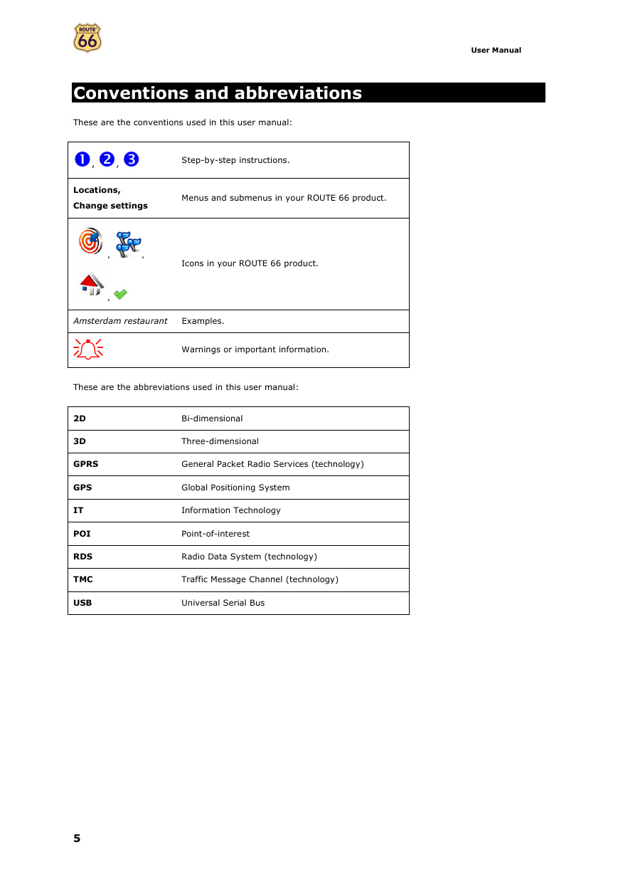
These are the conventions used in this user manual:
, ,
Locations,
Change settings
,
,
,
Step-by-step instructions.
Menus and submenus in your ROUTE 66 product.
Icons in your ROUTE 66 product.
Amsterdam restaurant
Examples.
Warnings or important information.
These are the abbreviations used in this user manual:
2D
3D
Bi-dimensional
Three-dimensional
GPRS
General Packet Radio Services (technology)
GPS
IT
POI
RDS
TMC
USB
Global Positioning System
Information Technology
Point-of-interest
Radio Data System (technology)
Traffic Message Channel (technology)
Universal Serial Bus
5
�
User Manual
Introduction
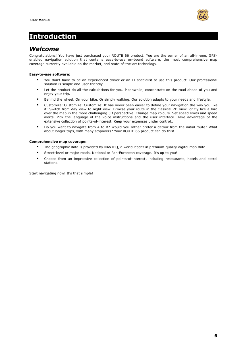
Welcome
Congratulations! You have just purchased your ROUTE 66 product. You are the owner of an all-in-one, GPS-
enabled navigation solution that contains easy-to-use on-board software, the most comprehensive map
coverage currently available on the market, and state-of-the-art technology.
Easy-to-use software:
�
�
You don’t have to be an experienced driver or an IT specialist to use this product. Our professional
solution is simple and user-friendly.
Let the product do all the calculations for you. Meanwhile, concentrate on the road ahead of you and
enjoy your trip.
� Behind the wheel. On your bike. Or simply walking. Our solution adapts to your needs and lifestyle.
� Customize! Customize! Customize! It has never been easier to define your navigation the way you like
it! Switch from day view to night view. Browse your route in the classical 2D view, or fly like a bird
over the map in the more challenging 3D perspective. Change map colours. Set speed limits and speed
alerts. Pick the language of the voice instructions and the user interface. Take advantage of the
extensive collection of points-of-interest. Keep your expenses under control...
� Do you want to navigate from A to B? Would you rather prefer a detour from the initial route? What
about longer trips, with many stopovers? Your ROUTE 66 product can do this!
Comprehensive map coverage:
The geographic data is provided by NAVTEQ, a world leader in premium-quality digital map data.
�
� Street-level or major roads. National or Pan-European coverage. It’s up to you!
� Choose from an impressive collection of points-of-interest, including restaurants, hotels and petrol
stations.
Start navigating now! It’s that simple!
6
�
User Manual
Your first trip: Navigate to a destination
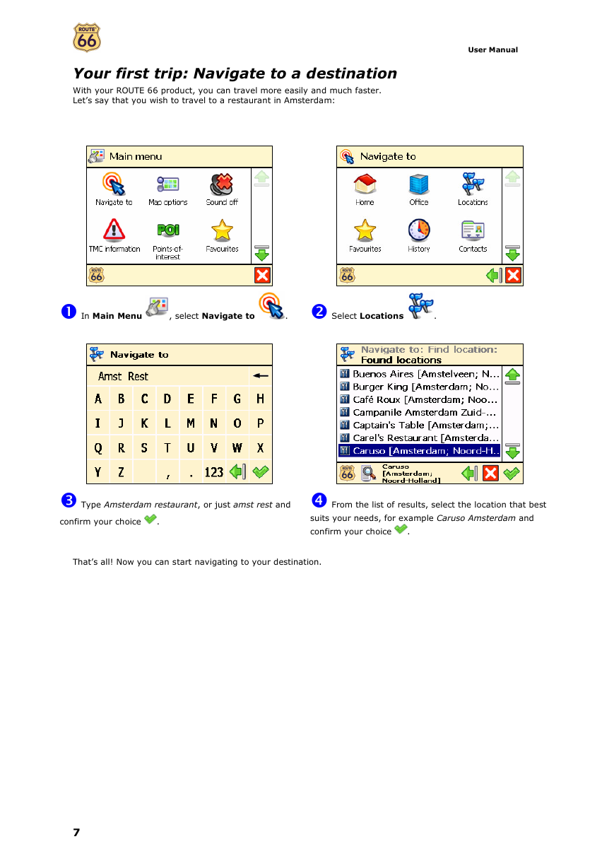
With your ROUTE 66 product, you can travel more easily and much faster.
Let’s say that you wish to travel to a restaurant in Amsterdam:
In Main Menu
, select Navigate to
.
Select Locations
.
Type Amsterdam restaurant, or just amst rest and
From the list of results, select the location that best
confirm your choice
.
suits your needs, for example Caruso Amsterdam and
That’s all! Now you can start navigating to your destination.
confirm your choice
.
7
�
User Manual
First steps
Prepare your device
To start using your ROUTE 66 product, you have to carry out the following 4 steps:
Charge the battery of the device.
Insert the memory card into your device.
Switch on your device and wait for a fixed GPS position.
Launch your ROUTE 66 product.
Understanding the navigation screen
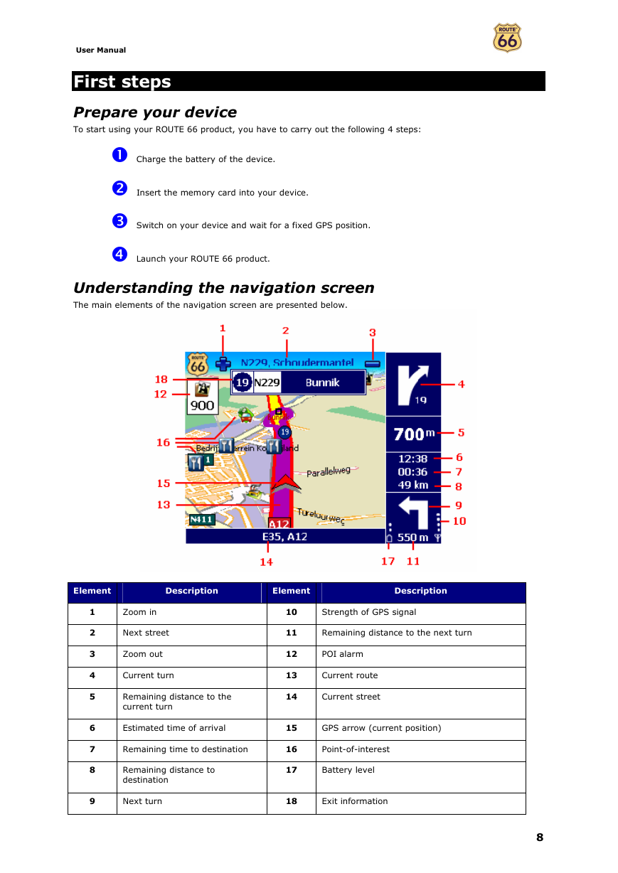
The main elements of the navigation screen are presented below.
Element
Description
Element
Description
1
2
3
4
5
6
7
8
Zoom in
Next street
Zoom out
10
Strength of GPS signal
11
Remaining distance to the next turn
12
POI alarm
Current turn
13
Current route
Remaining distance to the
current turn
14
Current street
Estimated time of arrival
15
GPS arrow (current position)
Remaining time to destination
16
Point-of-interest
Remaining distance to
destination
17
Battery level
9
Next turn
18
Exit information
8
�


 2023年江西萍乡中考道德与法治真题及答案.doc
 2012年重庆南川中考生物真题及答案.doc
 2013年江西师范大学地理学综合及文艺理论基础考研真题.doc
 2020年四川甘孜小升初语文真题及答案I卷.doc
 2020年注册岩土工程师专业基础考试真题及答案.doc
 2023-2024学年福建省厦门市九年级上学期数学月考试题及答案.doc
 2021-2022学年辽宁省沈阳市大东区九年级上学期语文期末试题及答案.doc
 2022-2023学年北京东城区初三第一学期物理期末试卷及答案.doc
 2018上半年江西教师资格初中地理学科知识与教学能力真题及答案.doc
 2012年河北国家公务员申论考试真题及答案-省级.doc
 2020-2021学年江苏省扬州市江都区邵樊片九年级上学期数学第一次质量检测试题及答案.doc
 2022下半年黑龙江教师资格证中学综合素质真题及答案.doc