Using GPS Locate
Getting Acquainted
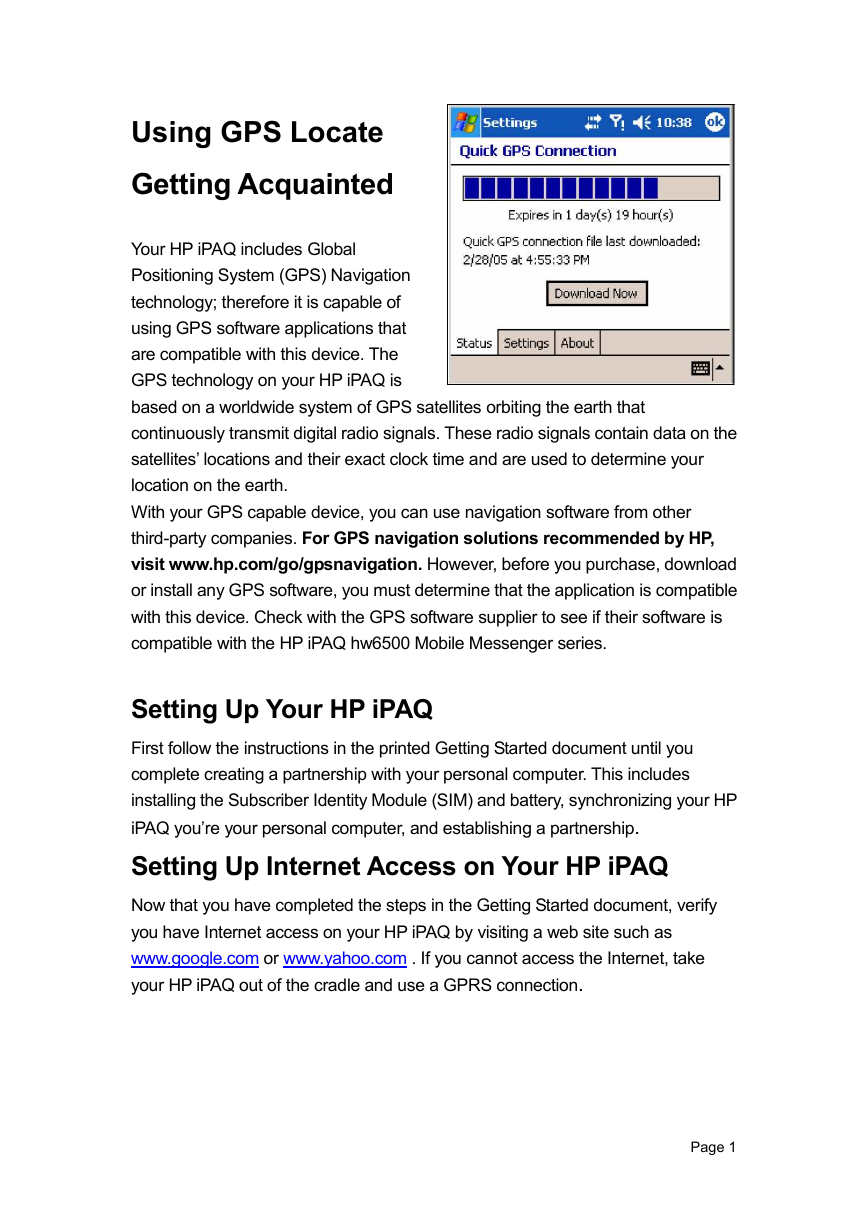
Your HP iPAQ includes Global
Positioning System (GPS) Navigation
technology; therefore it is capable of
using GPS software applications that
are compatible with this device. The
GPS technology on your HP iPAQ is
based on a worldwide system of GPS satellites orbiting the earth that
continuously transmit digital radio signals. These radio signals contain data on the
satellites’ locations and their exact clock time and are used to determine your
location on the earth.
With your GPS capable device, you can use navigation software from other
third-party companies. For GPS navigation solutions recommended by HP,
visit www.hp.com/go/gpsnavigation. However, before you purchase, download
or install any GPS software, you must determine that the application is compatible
with this device. Check with the GPS software supplier to see if their software is
compatible with the HP iPAQ hw6500 Mobile Messenger series.
Setting Up Your HP iPAQ
First follow the instructions in the printed Getting Started document until you
complete creating a partnership with your personal computer. This includes
installing the Subscriber Identity Module (SIM) and battery, synchronizing your HP
iPAQ you’re your personal computer, and establishing a partnership.
Setting Up Internet Access on Your HP iPAQ
Now that you have completed the steps in the Getting Started document, verify
you have Internet access on your HP iPAQ by visiting a web site such as
www.google.com or www.yahoo.com . If you cannot access the Internet, take
your HP iPAQ out of the cradle and use a GPRS connection.
Page 1
�
Using HP iPAQ Quick GPS
Connection Utility
To improve GPS hardware performance,
you need to enable the HP iPAQ Quick
GPS Connection Data Utility and
download the latest data file.
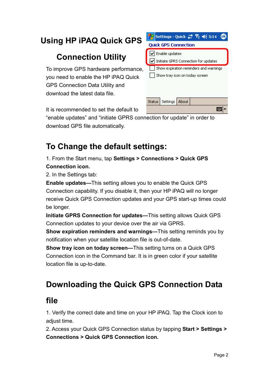
It is recommended to set the default to
“enable updates” and “initiate GPRS connection for update” in order to
download GPS file automatically.
To Change the default settings:
1. From the Start menu, tap Settings > Connections > Quick GPS
Connection icon.
2. In the Settings tab:
Enable updates—This setting allows you to enable the Quick GPS
Connection capability. If you disable it, then your HP iPAQ will no longer
receive Quick GPS Connection updates and your GPS start-up times could
be longer.
Initiate GPRS Connection for updates—This setting allows Quick GPS
Connection updates to your device over the air via GPRS.
Show expiration reminders and warnings—This setting reminds you by
notification when your satellite location file is out-of-date.
Show tray icon on today screen—This setting turns on a Quick GPS
Connection icon in the Command bar. It is in green color if your satellite
location file is up-to-date.
Downloading the Quick GPS Connection Data
file
1. Verify the correct date and time on your HP iPAQ. Tap the Clock icon to
adjust time.
2. Access your Quick GPS Connection status by tapping Start > Settings >
Connections > Quick GPS Connection icon.
Page 2
�
3. If your HP iPAQ shows that the file has expired, again verify the date and
time on the HP iPAQ is correct and press Download Now.
4. Tap OK to close the program.
TIP: In the future, you can access the Quick GPS Connection Utility by
tapping in the Command bar > Download Now.
After the GPS Quick Connection data file has been downloaded, GPS
performance Improves. We recommend to set default to automatically
download GPS file.
TIPS
1. Update GPS file every 48 hours manually or
allow auto download
2. Auto download by “Enable Updates” & “Initiate
GPRS for update”
3. Update GPS file first before using MapKing
NOTE: If you are going to use GPS Navigation in your vehicle for an extended period of time,
connect your HP iPAQ to an Auto adapter to save battery power. If you don’t have an Auto adapter,
you can order one at http://www.hp.com/apac/ipaq/accessories
GPS Technical Support and Service
FOR TECHNICAL SUPPORT on HP iPAQ
Quick GPS Utility:
Please refer to website at
http://ap.compaq.com.sg
GPS connection problem –Testing with GPS Viewer please refer to Page 48
Page 3
�
MapKing 3D
English version user’s Guide
For Microsoft Windows Pocket PC 2003
© 2002-2005, MapAsia.com Limited
Page 4
�
Copyright and Logo
Important message
1. Introduction
1.1 Product descriptions
1.2 Software and map version
1.3 MapKing 3D features
1.4 System requirement
2. Installation and activation
2.1 Product installation
2.1.1 Main program installation
2.1.2 Map data installation
2.2 Product registration
2.2.1 Hardware code
2.2.2 Obtain registration code
2.2.3 Registration in pocket PC
2.2.4 Register MapKing with GPRS connection (optional)
2.3 Launch MapKing
2.3.1 Switch Map
2.3.2 Close Map
2.4 Remove MapKing 3D
2.5 Product upgrade
3. Basic functions
3.1 Search Functions
3.1.1 Search Startup
3.1.2 Index Search (by alphanumerical order)
3.1.3 Keyword Search (Wild Card Search)
3.1.4 POI Search (Point of Interest) Category
3.1.5 Search by Distance Range
3.1.6 District Center Location
3.1.7 Search by Co-ordinates
3.1.8 Search by Group Category (Q-find)
3.2 My Favorite function (My POI)
3.2.1 Build POI
3.2.2 Manage POI
3.2.3 Exit POI
Index
P.07
P.08
P.09
P.10
P.10
P.11
P.12
P.12
P.13
P.14
P.14
P.14
P.15
P.15
P.16
P.16
P.17
P.17
P.17
P.18
P.16
P.17
P.19
P.20
P.21
P.21
P.22
P.22
P.23
P.23
P.24
P.25
Page 5
�
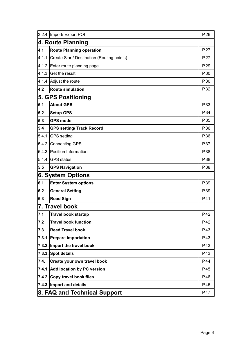
3.2.4 Import/ Export POI
4. Route Planning
4.1 Route Planning operation
4.1.1 Create Start/ Destination (Routing points)
4.1.2 Enter route planning page
4.1.3 Get the result
4.1.4 Adjust the route
4.2 Route simulation
5. GPS Positioning
5.1 About GPS
5.2 Setup GPS
5.3 GPS mode
5.4 GPS setting/ Track Record
5.4.1 GPS setting
5.4.2 Connecting GPS
5.4.3 Position Information
5.4.4 GPS status
5.5 GPS Navigation
6. System Options
6.1 Enter System options
6.2 General Setting
6.3 Road Sign
7. Travel book
7.1 Travel book startup
7.2 Travel book function
7.3 Read Travel book
7.3.1. Prepare importation
7.3.2. Import the travel book
7.3.3. Spot details
7.4. Create your own travel book
7.4.1. Add location by PC version
7.4.2. Copy travel book files
7.4.3 Import and details
8. FAQ and Technical Support
P.26
P.27
P.27
P.29
P.30
P.30
P.32
P.33
P.34
P.35
P.36
P.36
P.37
P.38
P.38
P.38
P.39
P.39
P.41
P.42
P.42
P.43
P.43
P.43
P.43
P.44
P.45
P.46
P.46
P.47
Page 6
�
Copyright and Logo
All title, ownership, derivative works and copyrights in the SOFTWARE are owned by
MapAsia and incorporated suppliers. No right, title or interest in or to any trademark, logo
or trade name of MapAsia or incorporated suppliers is granted under this AGREEMENT.
The Logo of MapAsia and MapKing is owned by City Country Consultancy Limited
.
Copyright of the GIS Database is owned by MapAsia.com Limited and Data partners’ that
have come to contract with and be specified by MapAsia.com
Copyright of India Map Data is owned by ADROITEC Information Systems Ltd.
Copyright of Indonesia Map Data is owned by PT. Duta Astakona Girinda
Copyright of Japan Map Data is owned by Alps Mapping Co., Ltd.
Copyright of Malaysia Map Data is owned by Geoinfo Services Sdn. Bhd.
Copyright of Philippine Map Data is owned by GIS Aranet Inc.
Copyright of Taiwan Map Data is owned or represented by Maction Technologies, Inc.
Copyright of Thailand Map Data is owned by. Lotus Consulting International Co Ltd
All other GIS Database is owned or represented by the MapAsia.com.
SOFTWARE PRODUCT LICENSE
The SOFTWARE is protected by local, international copyright laws and other intellectual
property laws treaties.
MapKing™ is the registered logo and or logo of MapAsia.com Limited in the United States
of American and other countries
MapAsia is the registered logo and or logo of MapAsia.com Limited in the United States of
American other countries
Microsoft is the registered logo and or logo of Microsoft Corporation in the United States of
American other countries
Pocket Outlook® is the registered logo and or logo of Microsoft Corporation in the United
States of American other countries
Other undeclared LOGO and Licenses belong to the owner of the copyright owner
Copyright © 2001-2005,
MapAsia.com Limited
City Country Consultancy Limited
Page 7
�
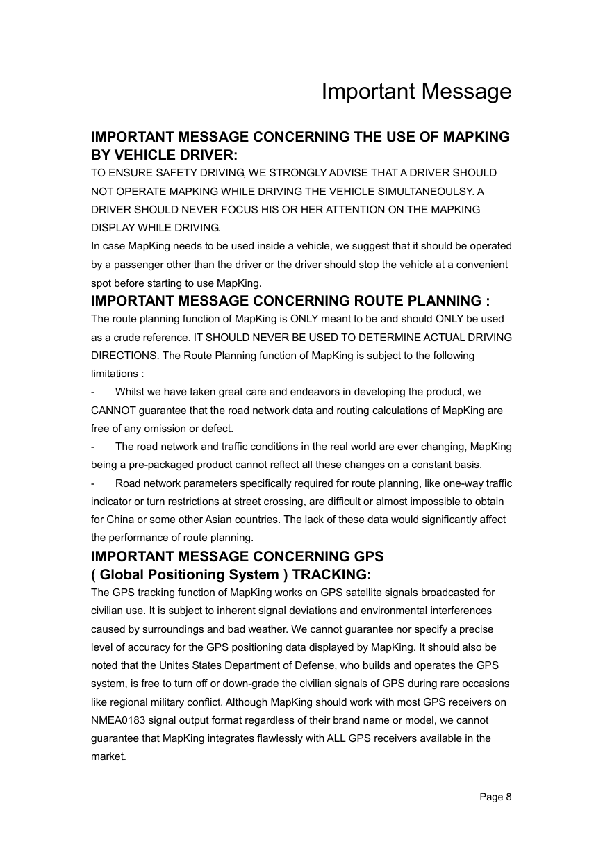
Important Message
IMPORTANT MESSAGE CONCERNING THE USE OF MAPKING
BY VEHICLE DRIVER:
TO ENSURE SAFETY DRIVING, WE STRONGLY ADVISE THAT A DRIVER SHOULD
NOT OPERATE MAPKING WHILE DRIVING THE VEHICLE SIMULTANEOULSY. A
DRIVER SHOULD NEVER FOCUS HIS OR HER ATTENTION ON THE MAPKING
DISPLAY WHILE DRIVING.
In case MapKing needs to be used inside a vehicle, we suggest that it should be operated
by a passenger other than the driver or the driver should stop the vehicle at a convenient
spot before starting to use MapKing.
IMPORTANT MESSAGE CONCERNING ROUTE PLANNING :
The route planning function of MapKing is ONLY meant to be and should ONLY be used
as a crude reference. IT SHOULD NEVER BE USED TO DETERMINE ACTUAL DRIVING
DIRECTIONS. The Route Planning function of MapKing is subject to the following
limitations :
- Whilst we have taken great care and endeavors in developing the product, we
CANNOT guarantee that the road network data and routing calculations of MapKing are
free of any omission or defect.
-
The road network and traffic conditions in the real world are ever changing, MapKing
being a pre-packaged product cannot reflect all these changes on a constant basis.
-
Road network parameters specifically required for route planning, like one-way traffic
indicator or turn restrictions at street crossing, are difficult or almost impossible to obtain
for China or some other Asian countries. The lack of these data would significantly affect
the performance of route planning.
IMPORTANT MESSAGE CONCERNING GPS
( Global Positioning System ) TRACKING:
The GPS tracking function of MapKing works on GPS satellite signals broadcasted for
civilian use. It is subject to inherent signal deviations and environmental interferences
caused by surroundings and bad weather. We cannot guarantee nor specify a precise
level of accuracy for the GPS positioning data displayed by MapKing. It should also be
noted that the Unites States Department of Defense, who builds and operates the GPS
system, is free to turn off or down-grade the civilian signals of GPS during rare occasions
like regional military conflict. Although MapKing should work with most GPS receivers on
NMEA0183 signal output format regardless of their brand name or model, we cannot
guarantee that MapKing integrates flawlessly with ALL GPS receivers available in the
market.
Page 8
�




 2023年江西萍乡中考道德与法治真题及答案.doc
 2012年重庆南川中考生物真题及答案.doc
 2013年江西师范大学地理学综合及文艺理论基础考研真题.doc
 2020年四川甘孜小升初语文真题及答案I卷.doc
 2020年注册岩土工程师专业基础考试真题及答案.doc
 2023-2024学年福建省厦门市九年级上学期数学月考试题及答案.doc
 2021-2022学年辽宁省沈阳市大东区九年级上学期语文期末试题及答案.doc
 2022-2023学年北京东城区初三第一学期物理期末试卷及答案.doc
 2018上半年江西教师资格初中地理学科知识与教学能力真题及答案.doc
 2012年河北国家公务员申论考试真题及答案-省级.doc
 2020-2021学年江苏省扬州市江都区邵樊片九年级上学期数学第一次质量检测试题及答案.doc
 2022下半年黑龙江教师资格证中学综合素质真题及答案.doc