logo资料库

Leica Pegasus Manager(new).pdf

第1页 / 共396页
第2页 / 共396页
第3页 / 共396页
第4页 / 共396页
第5页 / 共396页
第6页 / 共396页
第7页 / 共396页
第8页 / 共396页
资料共396页,剩余部分请下载后查看
Overview
1. Intro
1.1 General information
1.1.1 Symbols used in this manual
1.1.2 Assistance and Training
1.2 Workstations Requirements
1.2.1 Office workstations
1.2.1.1 Minimum requirements - office workstation
1.2.1.2 Recommend - office workstation
1.3 Software Installation
1.3.1 Common Requirements
1.3.2 Before the installation
1.3.3 Install Leica CLM Software
1.3.4 Install Leica Pegasus software
1.3.5 Workflow
2. Leica Pegasus Viewer
2.3.1 Open / Create a project
2.1 Graphic User Interface
2.1.1 Main Menu
2.1.2 Pegasus Manager Configuration
2.1.2.1 Copyright tab
2.1.2.2 System Configuration tab
2.1.2.3 3D Cursor & Parameters Configuration tab
2.1.2.4 Coordinate System tab
2.1.2.5 Laser Dataset
2.1.2.6 Video Catalogue
2.1.2.7 Configuration Wizard
2.1.3 Content Palette
2.1.4 Layer Attributes table
2.1.4.1 Statistics
2.1.5 Vector window
2.2 General toolbar
2.2.1 Navigation tools
2.2.2 Project
2.2.3 Data
2.2.4 Navigation
2.2.5 Video
2.2.6 Distance
2.2.7 Window
2.3 Map window
2.4 Leica Pegasus Video Image Window
2.4.1 Overview
2.4.2 Control the navigation through the trajectory
2.4.3 The Zoom Magnification in the Video Image Window
2.4.4 Configure the Order of displacement of the cameras
2.4.5 The activation of Camera Images
2.4.6 Open Spherical Images
2.4.7 Show / Hide Shapefile
2.4.8 Refresh the Video Image Window
2.4.9 Show LiDAR data on Video Image Window
2.4.10 Show LiDAR snapped points
2.4.11 Open Zoom Windows for camera frames visualization
2.4.12 Link Images and Point Cloud
2.4.13 Set the Aerial View of the stereo-window
2.4.14 Open the Point Cloud from a perspective view of the Camera
2.4.15 Snap to Point Cloud
2.4.16 Snap to Point Cloud depending on time
2.4.17 Acquire points for Camera Calibration
2.5 The Point Cloud Window
2.5.1 Configuration of the Point Cloud Window
2.5.1.1 Moving in the Point Cloud window
2.5.2 Dynamic Orthographic View
2.5.3 Synchronize the images based on cursor position
2.5.4 Show / Hide Shapefiles in the Point Cloud View
2.5.5 Snap to Point Cloud
2.5.6 D Snap
2.5.7 Parallax
2.5.8 Minimum Point Thickness
2.5.9 Field of View
2.5.10 LiDAR Attributes tab - General tab
2.5.10.1 The Color by…. options
2.5.10.2 View Type …
2.5.10.3 Point Cloud Limit Box
2.5.10.4 Open an Image in the Point Cloud Window
2.5.10.5 Open a Thermal Image in the Point Cloud Window
2.5.11 LiDAR Attributes tab - Classes tab
2.5.12 LiDAR Attributes tab - Tracks tab
2.5.12.1 LiDAR Attributes with dual scanner
2.5.13 Views settings
2.5.14 Planar Analysis
3. Mission Planning
3.1 Base station
3.1.1 Create Base Station Layer
3.1.2 Add a Base Station
3.1.3 Import Base Station NOVATEL file
3.1.4 Import from Leica SmartNet database
3.1.5 Import from user defined database
3.1.6 Toggle Base Station status
3.2 Trajectory
3.2.1 Create Trajectory Layer
3.2.2 Add Trajectory
3.3 Planning tools
3.3.1 Base station coverage
3.3.2 Satellite visibility analysis
3.3.3 Best time analysis
3.3.4 Export for MDA
4. Processing
4.1 General
4.2.2 Processing
4.2 Processing
4.2.1 Workflow
4.2.2.1 Stop Processing
4.3 Navigation preparation
4.3.1 Profiles and Process Type
4.3.2 GNSS and IMU parameters
4.3.2.1 GNSS Signal Filtering
4.3.2.2 GNSS Ambiguities Fix
4.3.2.3 Measurement constraints
4.3.2.4 Velocity constraints
4.3.2.5 ZUPT Constraints
4.3.2.6 Trajectory Quality Factor
4.3.3 Import scanner files
4.3.3.1 Pegasus System with Profiler Z + F 5012/9012
4.3.3.2 Pegasus System with HDS P20/P40
4.3.3.3 Pegasus Systems with Velodyne configuration
4.4 SLAM processing
4.4.1 Processing Time
4.4.2 Basic SLAM
4.4.3 Advanced SLAM
4.5 JPEG Extraction
4.6 Time alignment
4.7 Import trajectory data
4.8 Generate image orientation
4.9 Generate 3D Point Cloud
4.9.1 Generate 3D Point Cloud with dual scanner
4.9.2 Create PegTracks
4.9.3 Point Cloud Filtering (opt)
4.9.3.1 Classification
4.10 Generate Spheric Images (opt)
4.11 The Processing of data
4.12 Multiple Instances in simultaneous
4.13 Leica Pegasus Processing - Publishing
4.13.1 Publishing to TopoDOT 10.5.0.17
4.13.2 Publishing to LAS1.2
4.13.2.1 Export LAS files with dual scanner database
4.13.3 Publishing to E57
4.13.4 Publishing to AutoDesk Recap 3.0.0.52
4.13.5 Publishing to Depth images and ptx
4.13.6 Publishing to Pegasus Web Viewer
4.13.7 Blur faces and car license plates
4.14 Leica Pegasus Processing - Utilities
4.14.1 Image Utilities
4.14.1.1 Generate Dataset from Pause/Rec
4.14.1.2 Extract dataset on Frame Number Interval
4.14.1.3 Export orientation parameters
4.14.1.4 Import E57 File Format
4.14.1.5 Road sign automatic detection
4.14.1.6 Write EXIF information
4.14.1.7 Generate thermal images
4.14.2 Point Cloud Utilities
4.14.2.1 Generate PTS files from point cloud
4.14.2.2 LAS to HPC
4.14.2.3 Search SDC and TRJ Link
4.14.2.4 Generate Hexagon files (*.hpc) from GLD
4.14.2.5 Generate Hex. files (*.hpg) from point cloud
4.14.2.6 Import E57 File Format
4.14.2.7 Link AVU with HPC files
4.14.2.8 Point Cloud Filtering
4.14.2.9 Delete points with low quality
4.14.2.10 Classify points with quality
4.14.3 Coordinate Utilities
4.14.3.1 Coordinate Conversion Manager
4.14.3.2 Re-Project whole dataset
4.14.3.3 Export Trajectory as NMEA
4.14.3.4 Scaling dataset
4.14.3.5 Trajectory rigid roto-translation
4.14.4 Other Utilities
4.14.4.1 Import CSV
4.14.4.2 Adjust annotations
4.14.4.3 Prepare dataset for delivery
4.14.4.4 Second scanner calibration
4.14.5 SLAM QC Tool
4.14.5.1 Project and Properties palette
4.14.5.2 Editing the Trajectories with Basic SLAM
4.14.5.3 Editing the Trajectories with Advanced SLAM
4.14.5.4 Continue Dataset Processing
5. Trajectory Adjustment tab
5.1 Workflow
5.2 Add Features
5.3 Edit Features
5.4 Snap
5.5 Map window
5.6 Layer Attributes table
5.6.5.1 Field Calculator
5.6.1 Point Cloud window
5.7 Advanced Tools
5.7.1 Multi-Pass Workflow
5.7.2 Multi-Pass Detection
5.7.3 Multi-Pass detection from images
5.7.4 Multi-Pass Manual Link
5.7.5 Multi-Pass Measurement
5.7.6 Multi-Pass Adjustment
5.7.7 Multi-Pass Show Links
5.7.8 QC - Review and Report
5.7.8.1 QC Report
5.7.9 Ground Target Recognition
5.7.10 Ground Target <-> Multi-Pass Manual Link
5.8 Points
5.8.1 Set Manual Control Point
5.8.2 Set Manual Tie Point
5.8.3 Convert Check <-> Control Point
5.9 Point Utilities
5.9.1 Height Auto Adjustment
5.9.2 3D Automatic Adjustment
5.9.3 Export Control Points
5.9.3.1 Export Control Points for Trajectory Adjustment
5.9.3.2 Export Control Points for Trajectory Adjustment by time
5.9.3.3 Export Control Points for Trajectory Adjustment by position
5.9.4 Points Report
5.9.5 Repair Control Point Layer
5.10 Camera Calibration
5.10.1 Camera Calibration Process
6. Pegasus Road:Factory
6.1 Graphic User Interface
6.2 Processing Interval
6.3 Add Features
6.4 Edit Features
6.5 Classification - Road Extract
6.6 Calculations
6.6.1 DTM
6.6.2 Clearance
6.6.3 Control Line
6.7 Batch Features Extraction
6.7.1 Pedestrian Crossing
6.7.2 Lane Lines
6.7.3 Wires
6.7.4 Curbs
6.7.5 Barriers
6.7.6 Travel Lane
7. Real time data exchange
8. Appendix
8.1 Appendix 01 - Vector window
8.1.1 General tab
8.1.1.1 Parameters
8.1.1.2 Painting
8.1.1.3 Info
8.1.2 Section tab
8.1.2.1 Renderer tab
8.1.2.2 Line tab
8.1.2.3 Area tab
8.1.2.4 Marker tab
8.1.2.5 Label tab
8.1.2.6 Chart tab
8.1.2.7 3D tab
8.2 Appendix 02 - Value label formatting
8.2.1 Formatting of NUMBER and FLOT type attributes
8.2.2 Formatting of BOOLEAN type attributes
8.2.3 Formatting of DATE type attributes
8.2.4 Formatting of STRING type attributes
8.3 Appendix 03 - SmartNet - Permanent Reference Station. RINEX Generation
8.4 Appendix 04 - SmartNet - Virtual Reference Station Generation
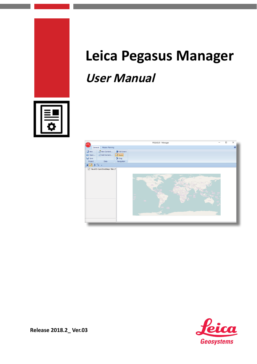
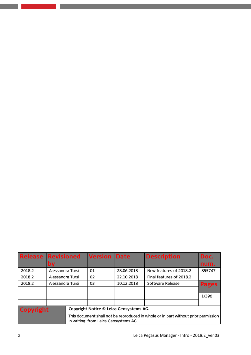
Leica Pegasus Manager User Manual Release 2018.2_ Ver.03
Release Revisioned 2018.2 2018.2 2018.2 by Alessandra Tursi Alessandra Tursi Alessandra Tursi Version Date Description 01 02 03 28.06.2018 22.10.2018 10.12.2018 New features of 2018.2 Final features of 2018.2 Software Release Doc. num. 855747 Pages 1/396 Copyright Copyright Notice © Leica Geosystems AG. This document shall not be reproduced in whole or in part without prior permission in writing from Leica Geosystems AG. 2 Leica Pegasus Manager - Intro - 2018.2_ver.03
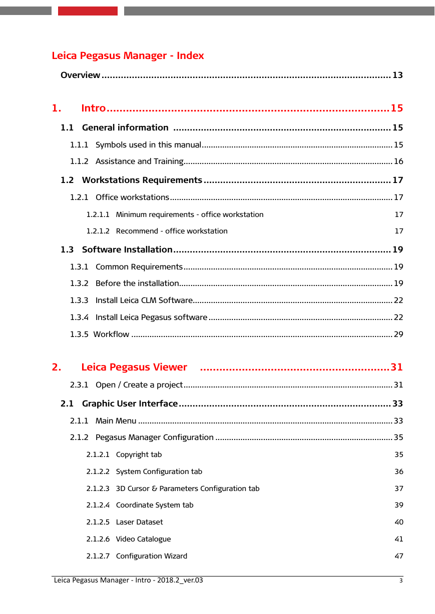
Leica Pegasus Manager - Index Overview ......................................................................................................... 13 1. Intro ........................................................................................15 1.1 General information ............................................................................... 15 1.1.1 Symbols used in this manual .................................................................................... 15 1.1.2 Assistance and Training ............................................................................................ 16 1.2 Workstations Requirements .................................................................... 17 1.2.1 Office workstations .................................................................................................. 17 1.2.1.1 Minimum requirements - office workstation 1.2.1.2 Recommend - office workstation 17 17 1.3 Software Installation ............................................................................... 19 1.3.1 Common Requirements ............................................................................................ 19 1.3.2 Before the installation.............................................................................................. 19 1.3.3 Install Leica CLM Software........................................................................................ 22 1.3.4 Install Leica Pegasus software ................................................................................. 22 1.3.5 Workflow ................................................................................................................... 29 2. Leica Pegasus Viewer ...........................................................31 2.3.1 Open / Create a project ............................................................................................ 31 2.1 Graphic User Interface ............................................................................. 33 2.1.1 Main Menu ................................................................................................................ 33 2.1.2 Pegasus Manager Configuration .............................................................................. 35 2.1.2.1 Copyright tab 2.1.2.2 System Configuration tab 2.1.2.3 3D Cursor & Parameters Configuration tab 2.1.2.4 Coordinate System tab 2.1.2.5 Laser Dataset 2.1.2.6 Video Catalogue 2.1.2.7 Configuration Wizard 35 36 37 39 40 41 47 3 Leica Pegasus Manager - Intro - 2018.2_ver.03
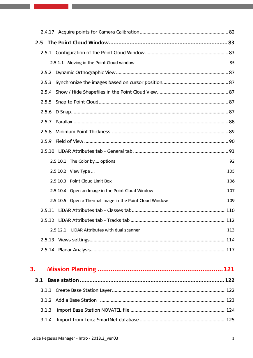
2.1.3 Content Palette ........................................................................................................ 48 2.1.4 Layer Attributes table ............................................................................................. 50 2.1.4.1 Statistics 51 2.1.5 Vector window .......................................................................................................... 52 2.2 General toolbar ....................................................................................... 53 2.2.1 Navigation tools ....................................................................................................... 53 2.2.2 Project ....................................................................................................................... 55 2.2.3 Data .......................................................................................................................... 55 2.2.4 Navigation ................................................................................................................. 56 2.2.5 Video ......................................................................................................................... 56 2.2.6 Distance .................................................................................................................... 57 2.2.7 Window ..................................................................................................................... 59 2.3 Map window ............................................................................................ 61 2.4 Leica Pegasus Video Image Window ......................................................... 63 2.4.1 Overview ................................................................................................................... 63 2.4.2 Control the navigation through the trajectory ........................................................ 64 2.4.3 The Zoom Magnification in the Video Image Window ............................................. 66 2.4.4 Configure the Order of displacement of the cameras ............................................ 67 2.4.5 The activation of Camera Images ............................................................................. 68 2.4.6 Open Spherical Images ............................................................................................. 69 2.4.7 Show / Hide Shapefile .............................................................................................. 70 2.4.8 Refresh the Video Image Window ............................................................................ 70 2.4.9 Show LiDAR data on Video Image Window ............................................................... 71 2.4.10 Show LiDAR snapped points .................................................................................. 72 2.4.11 Open Zoom Windows for camera frames visualization ........................................ 73 2.4.12 Link Images and Point Cloud .................................................................................. 78 2.4.13 Set the Aerial View of the stereo-window ............................................................ 80 2.4.14 Open the Point Cloud from a perspective view of the Camera ............................ 80 2.4.15 Snap to Point Cloud ................................................................................................ 82 2.4.16 Snap to Point Cloud depending on time ................................................................ 82 4 Leica Pegasus Manager - Intro - 2018.2_ver.03
2.4.17 Acquire points for Camera Calibration ................................................................... 82 2.5 The Point Cloud Window .......................................................................... 83 2.5.1 Configuration of the Point Cloud Window ............................................................... 83 2.5.1.1 Moving in the Point Cloud window 85 2.5.2 Dynamic Orthographic View ..................................................................................... 87 2.5.3 Synchronize the images based on cursor position.................................................. 87 2.5.4 Show / Hide Shapefiles in the Point Cloud View ...................................................... 87 2.5.5 Snap to Point Cloud .................................................................................................. 87 2.5.6 D Snap ....................................................................................................................... 87 2.5.7 Parallax ...................................................................................................................... 88 2.5.8 Minimum Point Thickness ........................................................................................ 89 2.5.9 Field of View ............................................................................................................. 90 2.5.10 LiDAR Attributes tab - General tab ........................................................................ 91 2.5.10.1 The Color by…. options 2.5.10.2 View Type … 2.5.10.3 Point Cloud Limit Box 2.5.10.4 Open an Image in the Point Cloud Window 2.5.10.5 Open a Thermal Image in the Point Cloud Window 92 105 106 107 109 2.5.11 LiDAR Attributes tab - Classes tab .......................................................................110 2.5.12 LiDAR Attributes tab - Tracks tab ........................................................................112 2.5.12.1 LiDAR Attributes with dual scanner 113 2.5.13 Views settings .......................................................................................................114 2.5.14 Planar Analysis ......................................................................................................117 3. Mission Planning ...................................................................121 3.1 Base station .......................................................................................... 122 3.1.1 Create Base Station Layer ......................................................................................122 3.1.2 Add a Base Station ...............................................................................................123 3.1.3 Import Base Station NOVATEL file ........................................................................124 3.1.4 Import from Leica SmartNet database .................................................................125 5 Leica Pegasus Manager - Intro - 2018.2_ver.03
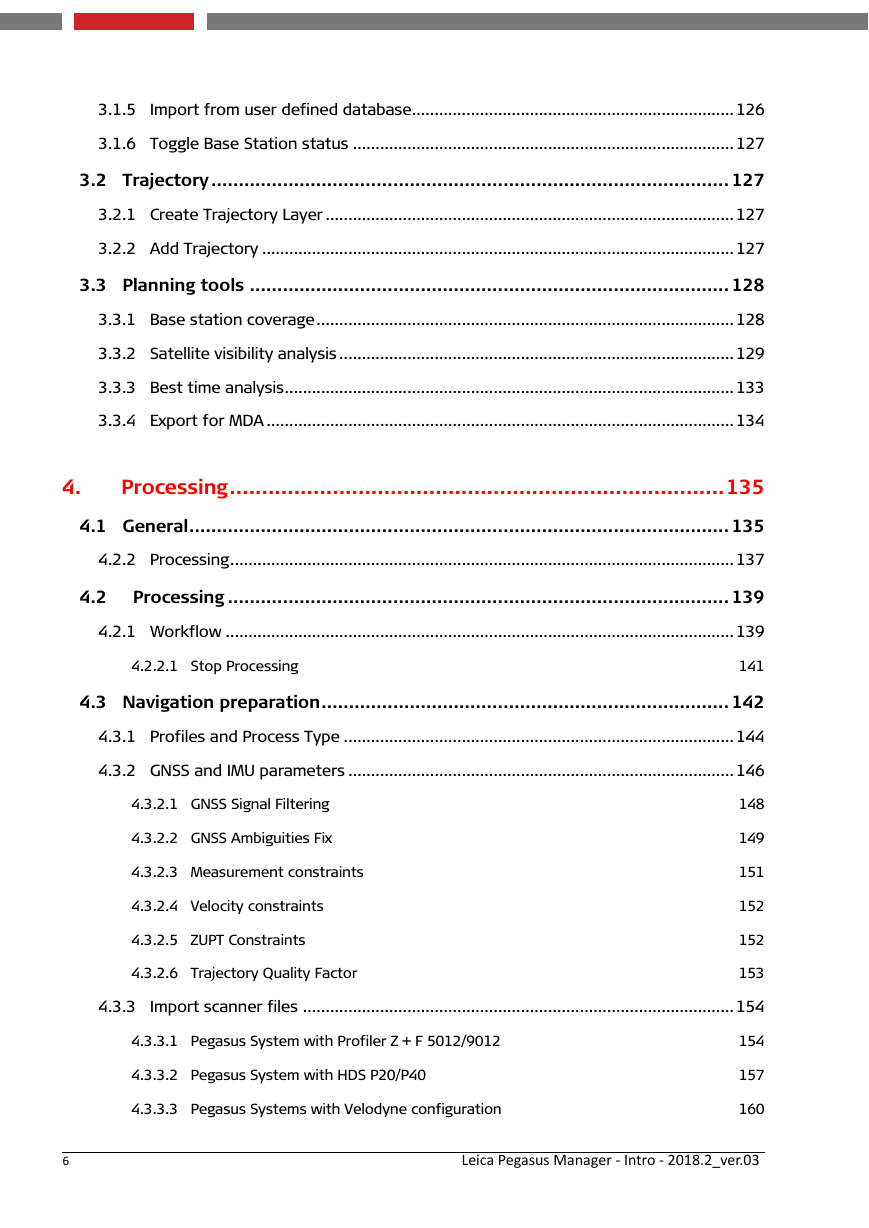
3.1.5 Import from user defined database .......................................................................126 3.1.6 Toggle Base Station status ....................................................................................127 3.2 Trajectory .............................................................................................. 127 3.2.1 Create Trajectory Layer ..........................................................................................127 3.2.2 Add Trajectory ........................................................................................................127 3.3 Planning tools ....................................................................................... 128 3.3.1 Base station coverage ............................................................................................128 3.3.2 Satellite visibility analysis .......................................................................................129 3.3.3 Best time analysis ...................................................................................................133 3.3.4 Export for MDA .......................................................................................................134 4. Processing .............................................................................135 4.1 General .................................................................................................. 135 4.2.2 Processing ...............................................................................................................137 4.2 Processing ........................................................................................... 139 4.2.1 Workflow ................................................................................................................139 4.2.2.1 Stop Processing 141 4.3 Navigation preparation .......................................................................... 142 4.3.1 Profiles and Process Type ......................................................................................144 4.3.2 GNSS and IMU parameters .....................................................................................146 4.3.2.1 GNSS Signal Filtering 4.3.2.2 GNSS Ambiguities Fix 4.3.2.3 Measurement constraints 4.3.2.4 Velocity constraints 4.3.2.5 ZUPT Constraints 4.3.2.6 Trajectory Quality Factor 148 149 151 152 152 153 4.3.3 Import scanner files ...............................................................................................154 4.3.3.1 Pegasus System with Profiler Z + F 5012/9012 4.3.3.2 Pegasus System with HDS P20/P40 4.3.3.3 Pegasus Systems with Velodyne configuration 154 157 160 6 Leica Pegasus Manager - Intro - 2018.2_ver.03
4.4 SLAM processing .................................................................................. 162 4.4.1 Processing Time ......................................................................................................164 4.4.2 Basic SLAM ..............................................................................................................165 4.4.3 Advanced SLAM ......................................................................................................166 4.5 JPEG Extraction ..................................................................................... 167 4.6 Time alignment ...................................................................................... 168 4.7 Import trajectory data ......................................................................... 171 4.8 Generate image orientation ................................................................... 176 4.9 Generate 3D Point Cloud ....................................................................... 178 4.9.1 Generate 3D Point Cloud with dual scanner ..........................................................183 4.9.2 Create PegTracks ....................................................................................................184 4.9.3 Point Cloud Filtering (opt) ....................................................................................185 4.9.3.1 Classification 187 4.10 Generate Spheric Images (opt) ............................................................ 188 4.11 The Processing of data ........................................................................ 192 4.12 Multiple Instances in simultaneous .................................................... 194 4.13 Leica Pegasus Processing - Publishing .................................................. 195 4.13.1 Publishing to TopoDOT 10.5.0.17 ........................................................................195 4.13.2 Publishing to LAS1.2 ..............................................................................................197 4.13.2.1 Export LAS files with dual scanner database 200 4.13.3 Publishing to E57 ................................................................................................201 4.13.4 Publishing to AutoDesk Recap 3.0.0.52 ..............................................................202 4.13.5 Publishing to Depth images and ptx ....................................................................203 4.13.6 Publishing to Pegasus Web Viewer ......................................................................204 4.13.7 Blur faces and car license plates ..........................................................................205 4.14 Leica Pegasus Processing - Utilities ...................................................... 206 4.14.1 Image Utilities .......................................................................................................206 4.14.1.1 Generate Dataset from Pause/Rec 4.14.1.2 Extract dataset on Frame Number Interval 4.14.1.3 Export orientation parameters 207 209 211 7 Leica Pegasus Manager - Intro - 2018.2_ver.03
4.14.1.4 Import E57 File Format 4.14.1.5 Road sign automatic detection 4.14.1.6 Write EXIF information 4.14.1.7 Generate thermal images 212 213 214 214 4.14.2 Point Cloud Utilities .............................................................................................215 4.14.2.1 Generate PTS files from point cloud 4.14.2.2 LAS to HPC 4.14.2.3 Search SDC and TRJ Link 4.14.2.4 Generate Hexagon files (*.hpc) from GLD 4.14.2.5 Generate Hex. files (*.hpg) from point cloud 4.14.2.6 Import E57 File Format 4.14.2.7 Link AVU with HPC files 4.14.2.8 Point Cloud Filtering 4.14.2.9 Delete points with low quality 4.14.2.10 Classify points with quality 216 217 218 219 220 221 221 221 222 223 4.14.3 Coordinate Utilities ..............................................................................................224 4.14.3.1 Coordinate Conversion Manager 4.14.3.2 Re-Project whole dataset 4.14.3.3 Export Trajectory as NMEA 4.14.3.4 Scaling dataset 4.14.3.5 Trajectory rigid roto-translation 225 229 231 232 233 4.14.4 Other Utilities .......................................................................................................235 4.14.4.1 Import CSV 4.14.4.2 Adjust annotations 4.14.4.3 Prepare dataset for delivery 4.14.4.4 Second scanner calibration 236 237 238 239 4.14.5 SLAM QC Tool .......................................................................................................240 4.14.5.1 Project and Properties palette 4.14.5.2 Editing the Trajectories with Basic SLAM 4.14.5.3 Editing the Trajectories with Advanced SLAM 4.14.5.4 Continue Dataset Processing 8 241 248 251 256 Leica Pegasus Manager - Intro - 2018.2_ver.03
分享到:
收藏