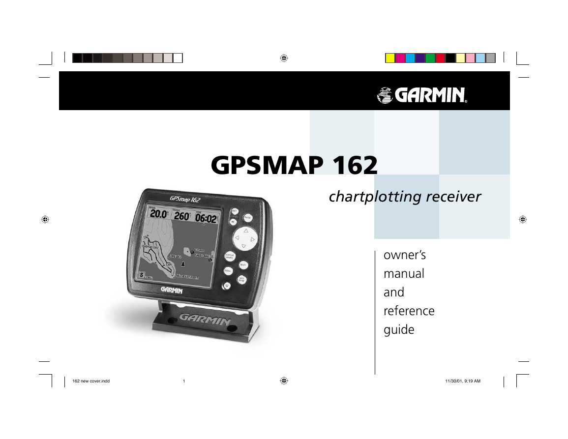
GPSMAP 162
chartplotting receiver
owner’s
manual
and
reference
guide
162 new cover.indd
1
11/30/01, 9:19 AM
�
© 2000-2001 GARMIN Corporation
Software Version 2.50 or above
Internal Database Version 2.00
GARMIN International, Inc., 1200 East 151st Street, Olathe, KS 66062, U.S.A.
Tel. 913/397.8200 or 800/800.1020
Fax 913/397.8282
GARMIN (Europe) Ltd., Unit 5, The Quadrangle, Abbey Park Industrial Estate, Romsey SO51 9AQ, U.K.
Tel. 44/1794.519944
Fax 44/1794.519222
GARMIN Corporation, No. 68, Jangshu 2nd Road, Shijr, Taipei County, Taiwan
Tel. 886/2.2642.9199
Fax 886/2.2642.9099
All rights reserved. Except as expressly provided herein, no part of this manual may be reproduced,
copied, transmitted, disseminated, downloaded or stored in any storage medium, for any purpose
without prior written consent of GARMIN Corporation. GARMIN Corporation hereby grants permission
to download a single copy of this manual onto a hard drive or other electronic storage medium to be
viewed for personal use, provided that such electronic or printed copy of this manual or revision must
contain the complete text of this copyright notice and provided further that any unauthorized commercial
distribution of this manual is strictly prohibited.
Information in this manual is subject to change without notice. GARMIN Corporation reserves the right
to change or improve its products and to make changes in the content without obligation to notify
any person or organization of such changes. Visit the GARMIN website (www.garmin.com) for current
updates and supplemental information concerning the use and operation of this and other GARMIN
products.
Introduction
Foreward
I
GARMIN®, Autolocate®, and TracBack® are registered trademarks,
MapSource™, and BlueChart™ are trademarks of GARMIN Cor-
poration and may not be used without the express permission of
GARMIN Corporation.
June 2001
Part Number 190-00169-00 Rev. C
Printed in Taiwan
i
�
Introduction
Preface
Preface and Registration
H
Why should you register your GARMIN GPS unit:
• Notifi cation of Product Updates
• Notifi cation of New Products
• Lost or Stolen unit tracking
ii
Congratulations on choosing one of the most advanced marine navigation systems available! The
GARMIN GPSMAP 162 utilizes the proven performance of GARMIN GPS and full featured mapping to
create an unsurpassed marine navigation chartplotter.
To get the most out of your new navigation system, take the time to go through this owner’s manual
and learn the operating procedures for your unit. This manual is broken down into two parts for
your convenience.
Part One introduces you to the GPSMAP 162 and provides a Getting Started tour so you may become
more familiar with the unit. This section will provide you with a basic working knowledge necessary to
use the unit to its fullest potential.
Part Two is divided into sections that provide detailed references to the advanced features and
operations of the GPSMAP 162. This allows you to concentrate on a specifi c topic quickly and look up
detailed information about the GPSMAP 162.
Customer Service Product Registration
Help us better support you by completing our on-line registration today! Have the serial
number of your GPSMAP 162 handy and connect to our website (www.garmin.com). Look for the Product
Registration link on the Home page. Also, be sure to record your serial number in the area provided
on page iv of this manual.
F
NOTE: If you have previously registered a GARMIN product purchase using a mail-in
registration card, we invite you to re-register using our NEW on-line system. Many
services provided by our new product registration system are now being automated and
re-registering your purchase ensures you the best possible support from GARMIN.
�
The GPS system is operated by the United States government, which is solely responsible for its
accuracy and maintenance. The system is subject to changes which could affect the accuracy and
performance of all GPS equipment. Although the GARMIN GPSMAP 162 is a precision electronic
NAVigation AID (NAVAID), any NAVAID can be misused or misinterpreted and, therefore, become
unsafe.
The electronic chart is an aid to navigation and is designed to facilitate the use of authorized
government charts, not replace them. Only offi cial government charts and notices to mariners contain all
information needed for safe navigation – and, as always, the user is responsible for their prudent use.
Use the GPSMAP 162 at your own risk. To reduce the risk of unsafe operation, carefully review and
understand all aspects of this Owner’s Manual—and thoroughly practice operation using the simulator
mode prior to actual use. When in actual use, carefully compare indications from the GPSMAP 162 to all
available navigation sources, including the information from other NAVAIDs, visual sightings, charts, etc.
For safety, always resolve any discrepancies before continuing navigation.
NOTE: This equipment generates, uses and can radiate radio frequency energy and, if not installed
and used in accordance with the instructions, may cause harmful interference to radio communications.
There is no guarantee that interference will not occur in a particular installation. If this equipment does
cause harmful interference, the user is encouraged to try to correct the interference by relocating the
equipment or connecting the equipment to a different circuit. Consult an authorized dealer or other
qualifi ed technician for additional help if these remedies do not correct the problem.
This device complies with Part 15 of the FCC limits for class B digital devices for home or offi ce use.
Operation is subject to the following conditions: (1) This device may not cause harmful interference, and
(2) this device must accept any interference received, including interference that may cause undesired
operation.
Introduction
Warning and Precautions
MAP DATA INFORMATION: One of the goals of GARMIN is to
provide customers with the most complete and accurate cartography
that is available to us at a reasonable cost. We use a combination
of governmental and private data sources, which we identify (as
required) in product literature and copyright messages displayed
to the consumer. Virtually all data sources contain inaccurate or
incomplete data to some degree. This is particularly true outside the
United States, where complete and accurate digital data is either not
available or prohibitively expensive.
I
CAUTION: IT IS THE USER’S RESPONSIBILITY TO USE THIS
PRODUCT PRUDENTLY. THIS PRODUCT IS INTENDED TO
BE USED ONLY AS A NAVIGATIONAL AID AND MUST
NOT BE USED FOR ANY PURPOSE REQUIRING PRECISE
MEASUREMENT OF DIRECTION, DISTANCE, LOCATION, OR
TOPOGRAPHY.
iii
�
Introduction
Warranty and
Serial Number
Serial Number
Use this area to record the serial number (8-digit number located on
the bottom of the unit) in case it is lost, stolen, or needs service. Be
sure to keep your original sales receipt in a safe place or attach a
photocopy inside the manual.
Serial Number:
I
The GARMIN GPSMAP 162 has no user-serviceable parts. Should
you ever encounter a problem with your unit, please take it to an
authorized GARMIN dealer for repairs.
The GPSMAP 162 is fastened shut with screws. Any attempt to open
the case to change or modify the unit in any way will void your
warranty and may result in permanent damage to the equipment.
iv
LIMITED WARRANTY
GARMIN Corporation warrants this product to be free from defects in materials and workmanship
for one year from the date of purchase. GARMIN will, at its sole option, repair or replace any
components that fail in normal use. Such repairs or replacement will be made at no charge to the
customer for parts or labor. The customer is, however, responsible for any transportation costs. This
warranty does not cover failures due to abuse, misuse, accident or unauthorized alteration or repairs.
THE WARRANTIES AND REMEDIES CONTAINED HEREIN ARE EXCLUSIVE AND IN LIEU OF
ALL OTHER WARRANTIES EXPRESS OR IMPLIED OR STATUTORY, INCLUDING ANY LIABILITY
ARISING UNDER ANY WARRANTY OF MERCHANTABILITY OR FITNESS FOR A PARTICULAR
PURPOSE, STATUTORY OR OTHERWISE. THIS WARRANTY GIVES YOU SPECIFIC LEGAL RIGHTS,
WHICH MAY VARY FROM STATE TO STATE.
IN NO EVENT SHALL GARMIN BE LIABLE FOR ANY INCIDENTAL, SPECIAL, INDIRECT OR
CONSEQUENTIAL DAMAGES, WHETHER RESULTING FROM THE USE, MISUSE, OR INABILITY
TO USE THIS PRODUCT OR FROM DEFECTS IN THE PRODUCT. SOME STATES DO NOT
ALLOW THE EXCLUSION OF INCIDENTAL OR CONSEQUENTIAL DAMAGES, SO THE ABOVE
LIMITATIONS MAY NOT APPLY TO YOU.
To obtain warranty service, call the GARMIN Customer Service department (913/397.8200) for a
returned merchandise tracking number. The unit should be securely packaged with the tracking number
clearly marked on the outside of the package and sent freight prepaid and insured to a GARMIN warranty
service station. A copy of the original sales receipt is required as the proof of purchase for warranty
repairs. GARMIN retains the exclusive right to repair or replace the unit or software or offer a full refund
of the purchase price at its sole discretion. SUCH REMEDY SHALL BE YOUR SOLE AND EXCLUSIVE
REMEDY FOR ANY BREACH OF WARRANTY.
�
Introduction
Capabilities
Designed for detailed electronic charting capability, the GARMIN GPSMAP 162 is a powerful naviga-
tion device that can give you the navigation information you need:
Precision Performance
• High-contrast, four-level gray, LCD screen with backlighting
• 12-channel parallel receiver tracks and uses up to 12 satellites for fast, accurate positioning
• WAAS Capable
• Differential-Ready
• Fully gasketed, high-impact plastic alloy case, waterproof to IEC 529-IPX-7
Advanced Navigating and Plotting
• 500 alphanumeric waypoints with selectable icons and comments
• Built-in Americas basemap to 20 miles includes detailed ocean, river and lake coastlines, cities,
interstates, US state highways and local thoroughfares
• 20 reversible routes with up to 30 waypoints each
• Uploadable maps up to 2.5 Megabytes of data using GARMIN’s MapSource PC products
• Coordinates: Lat/Lon, UTM/UPS, Loran TD, plus 15 grids, including Maidenhead
• TracBack route feature which allows you to quickly retrace your track log to a starting position
• Built-in simulator mode
v
�
Index Tab Top
Index Tab Bottom
vi
Before installing and getting started with your unit, please check to see that your package includes the
following items. If any parts are missing, please contact your GARMIN dealer immediately.
Standard Package:
• GPSMAP 162 Unit
• Bail Mount with knobs
• Mounting Bracket*
• Mount Bracket with Internal Antenna**
• GA 29 Remote Marine Antenna with 30’ cable and BNC connector*
• MapSource Fishing Hot Spots and MapSource Waterways & Lights CD-ROMs***
• Power/Data Cable
• AC Power/PC Interface Cable
• Protective Cover
• Owner’s Manual and Quick Reference Guide
Optional Accessories:
• Cigarette Lighter Adapter
• PC Interface Cable
• EURO A/C PC Adapter
• MapSource CDs: Fishing Hot Spots, BlueChart, US Waterways & Lights, US Topo, US Roads &
* Included with part number 010-00191-00.
** Included with part number 010-00192-00.
*** Included with part number 010-00192-03.
Recreation, European Roads & Recreation, and WorldMap
• GA 26C Remote Automobile Antenna with mounts, 30’ cable and BNC connector
• GA 29F Surface Mount GPS Antenna with 30’ cable and BNC connector
• Second Mounting Station
• Flush Mounting Kit
• 1” RAM Swivel Mount
�
Introduction . . . . . . . . . . . . . . . . . . . . . . . . . . i-viii
Foreword . . . . . . . . . . . . . . . . . . . . . . . . . . . . . i
Preface and Registration . . . . . . . . . . . . . . . . . .ii
Warnings and Precautions . . . . . . . . . . . . . . . iii
Warranty and Serial Number . . . . . . . . . . . . . iv
Capabilities . . . . . . . . . . . . . . . . . . . . . . . . . . . v
Packing List . . . . . . . . . . . . . . . . . . . . . . . . . . vi
“How To” Index . . . . . . . . . . . . . . . . . . . . . . viii
Section One: Getting Started . . . . . . . . . . . . 1-17
Keypad Usage, Selecting Options, Entering
Data, Initializing the Receiver, Power
On/Off, Contrast, Backlighting, Simulator,
Description of Main Pages, Simulated Tour
Section Two: Reference . . . . . . . . . . . . . . . . 18-71
Status Page and Options . . . . . . . . . . . . . . . . .18
Map Page and Options . . . . . . . . . . . . . . . . . .22
Map Page Confi guration . . . . . . . . . . . . . .29
Compass Page and Options . . . . . . . . . . . . . .35
Highway Page and Options . . . . . . . . . . . . . .36
Waypoints . . . . . . . . . . . . . . . . . . . . . . . . . . .38
Creating . . . . . . . . . . . . . . . . . . . . . . . . . .38
Reviewing and Editing . . . . . . . . . . . . . . .40
Options . . . . . . . . . . . . . . . . . . . . . . . . . .42
Nearest . . . . . . . . . . . . . . . . . . . . . . . . . . .44
Proximity . . . . . . . . . . . . . . . . . . . . . . . . .44
Going to a Destination . . . . . . . . . . . . . . . . . .46
TracBack . . . . . . . . . . . . . . . . . . . . . . . . . .48
MOB . . . . . . . . . . . . . . . . . . . . . . . . . . . . .50
Routes . . . . . . . . . . . . . . . . . . . . . . . . . . . . . .51
Creating . . . . . . . . . . . . . . . . . . . . . . . . . .51
Route List Page . . . . . . . . . . . . . . . . . . . . .53
Reviewing and Editing . . . . . . . . . . . . . . .54
Active Route Page . . . . . . . . . . . . . . . . . . . . . .58
Main Menu Page . . . . . . . . . . . . . . . . . . . . . . .59
Track Tab . . . . . . . . . . . . . . . . . . . . . . . . .60
Trip, Time and Pages Tabs . . . . . . . . . . . .62
System Tab . . . . . . . . . . . . . . . . . . . . . . . .63
Units Tab . . . . . . . . . . . . . . . . . . . . . . . . .64
Communication Tab . . . . . . . . . . . . . . . . .66
Alarm Tab . . . . . . . . . . . . . . . . . . . . . . . . .68
Celestial Tab . . . . . . . . . . . . . . . . . . . . . . .69
Tide Tab . . . . . . . . . . . . . . . . . . . . . . . . . .70
Appendix A: Loran TD . . . . . . . . . . . . . . . . . . . .72
Appendix B: Time Offsets . . . . . . . . . . . . . . . . .74
Appendix C: Messages . . . . . . . . . . . . . . . . . . . .75
Appendix D: Map Datums . . . . . . . . . . . . . . . . .77
Appendix E: Navigation Terms . . . . . . . . . . . . . .79
Appendix F: Specifi cations . . . . . . . . . . . . . . . .81
Appendix G: Installation . . . . . . . . . . . . . . . . . .82
Appendix H: Advanced NMEA Setup . . . . . . . . .85
Appendix I: Index . . . . . . . . . . . . . . . . . . . . . . .86
Introduction
Table of Contents
vii
�



 2023年江西萍乡中考道德与法治真题及答案.doc
 2012年重庆南川中考生物真题及答案.doc
 2013年江西师范大学地理学综合及文艺理论基础考研真题.doc
 2020年四川甘孜小升初语文真题及答案I卷.doc
 2020年注册岩土工程师专业基础考试真题及答案.doc
 2023-2024学年福建省厦门市九年级上学期数学月考试题及答案.doc
 2021-2022学年辽宁省沈阳市大东区九年级上学期语文期末试题及答案.doc
 2022-2023学年北京东城区初三第一学期物理期末试卷及答案.doc
 2018上半年江西教师资格初中地理学科知识与教学能力真题及答案.doc
 2012年河北国家公务员申论考试真题及答案-省级.doc
 2020-2021学年江苏省扬州市江都区邵樊片九年级上学期数学第一次质量检测试题及答案.doc
 2022下半年黑龙江教师资格证中学综合素质真题及答案.doc