Introduction to
UCL Depthmap 10
Version 10.08.00r
Joao Pinelo, Alasdair Turner
September2010
�
Introduction to Depthmap
Objectives
•Ease-up the first contact with the software
•Understand potential and limitations
•Learn general proceedings
•Cover operational issues which may be less documented
�
Introduction to Depthmap
Outline
1.Introduction (3)
6.Segment Map Analysis (44)
2.Drawing files (7)
7.Data Management/Analysis (50)
3.Visibility Graph Analysis (14)
8.Agents (57)
4. Convex Map Analysis (27)
9.Conclusion (59)
5. Axial Map Analysis (37)
�
Introduction
Why use Depthmap?
Research findings
What is Depthmap? What it does and doesn’t.
It is a tool for topological analysis
The analysis of layouts is achieved through the
juxtaposition of graphs
The graphs are analysed
�
A brief summary of Research Findings
•Topologically based measures (integration, which is a measure of
topological accessibility) correlates significantly with pedestrian and
vehicular movement patterns.
•Isovist properties, such as area, correlate with spatial behaviour.
•The representations of layouts (as convex, axial or visibility graphs) and
the topological and angular analysis seem to have a correspondence to
the way humans cognise space, maybe because they reflect
embodiment.
References
Dalton, R. C. 2002, "Is spatial intelligibility critical to the design of large-scale virtual environments?", International
Journal of Design Computing, vol. 4.
Hillier, B. 1999, "The hidden geometry of deformed grids: or, why space syntax works, when it looks as though it
shouldn't", Environment and Planning B: Planning and Design - Pion Ltd, vol. 26, no. 2, pp. 169-191.
Hillier, B., Penn, A., Hanson, J., Grajewski, T., & Xu, J. 1993, "Natural Movement - Or, Configuration and Attraction in Urban
Pedestrian Movement", Environment and Planning B: Planning and Design - Pion Ltd, vol. 20, no. 1, pp. 29-66.
Hillier, B. & Iida, S. "Network and Psychological Effects in Urban Movement", A. G. Cohn & D. M. Mark, eds., Springer-
Verlag Berlin Heidelberg, pp. 475-490.
Hölscher, C., Brösamle, M., Vrachliotis, G. (in press). Challenges in Multi-level Wayfinding: A Case-study with Space
Syntax technique. Environment and Planning B: Planning & Design.
�
Research Findings
References (cont.)
Peponis, J., Dalton, R. C., Wineman, J., & Dalton, N. 2004, "Measuring the effects of layout upon visitors' spatial
behaviors in open plan exhibition settings", Environment and Planning B: Planning and Design - Pion Ltd, vol. 31, no. 3,
pp. 453-473.
Peponis, J., Zimring, C., & Choi, Y. K. 1990, "Finding the Building in Wayfinding", Environment and Behavior, vol. 22, no.
5, pp. 555-590.
Turner, A. (2007) From axial to road-centre lines: a new representation for space syntax and a new model of route choice
for transport network analysis. Environment and Planning B: Planning and Design, 34 (3). pp. 539-555.
Turner, A. (2009) The role of angularity in route choice: an analysis of motorcycle courier GPS traces. In: Stewart
Hornsby, K. and Claramunt, C. and Denis, M. and Ligozat, G., (eds.) Spatial Information Theory.Lecture Notes in
Computer Science: Theoretical Computer Science and General Issues (5756 ). ,Springer Verlag, Berlin/ Heidelberg,
Germany, pp. 489-504.
Turner, Alasdair and Doxa, Maria and O'Sullivan, David and Penn, Alan (2001) From isovists to visibility graphs: a
methodology for the analysis of architectural space. Environment and Planning B: Planning and Design, 28 (1). pp. 103-
121.
Turner, Alasdair and Penn, Alan (2002) Encoding natural movement as an agent-based system: an investigation into
human pedestrian behaviour in the built environment. Environment and Planning B: Planning and Design, 29 . pp. 473-
490.
Wiener, J. M., Gerald, F., Rossmanith, N., Reichelt, A., Mallot, H. A., & Bulthoff, H. H. 2007, "Isovist analysis captures
properties of space relevant for locomotion and experience", Perception, vol. 36, pp. 1066-1083.
Zimring, C. & Dalton, R. C. 2003, "Linking objective measures of space to cognition and action", Environment and
Behavior, vol. 35, no. 1, pp. 3-16.
�
Drawing files
Opening and importing
Viewing
Panning and zooming
Saving Depthmap files
�
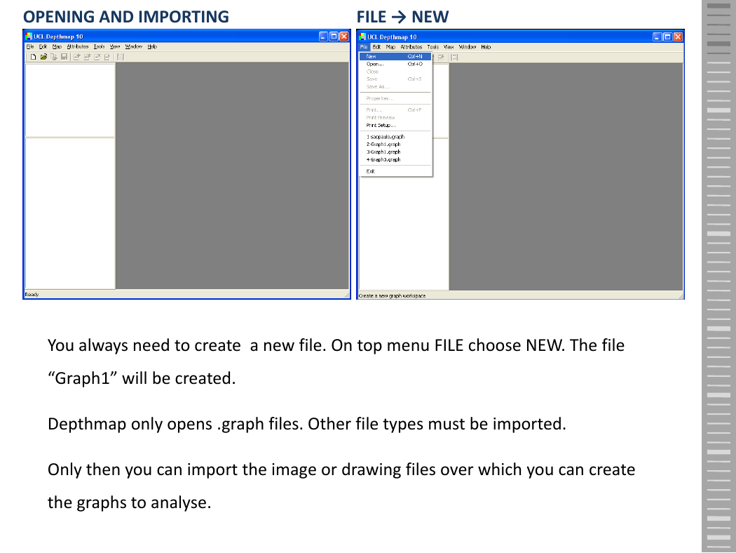
OPENING AND IMPORTING
FILE → NEW
You always need to create a new file. On top menu FILE choose NEW. The file
“Graph1” will be created.
Depthmap only opens .graph files. Other file types must be imported.
Only then you can import the image or drawing files over which you can create
the graphs to analyse.
�


 2023年江西萍乡中考道德与法治真题及答案.doc
 2012年重庆南川中考生物真题及答案.doc
 2013年江西师范大学地理学综合及文艺理论基础考研真题.doc
 2020年四川甘孜小升初语文真题及答案I卷.doc
 2020年注册岩土工程师专业基础考试真题及答案.doc
 2023-2024学年福建省厦门市九年级上学期数学月考试题及答案.doc
 2021-2022学年辽宁省沈阳市大东区九年级上学期语文期末试题及答案.doc
 2022-2023学年北京东城区初三第一学期物理期末试卷及答案.doc
 2018上半年江西教师资格初中地理学科知识与教学能力真题及答案.doc
 2012年河北国家公务员申论考试真题及答案-省级.doc
 2020-2021学年江苏省扬州市江都区邵樊片九年级上学期数学第一次质量检测试题及答案.doc
 2022下半年黑龙江教师资格证中学综合素质真题及答案.doc