What's New in v8.0
Getting Started
Hardware Suggestions
Quick Terrain Modeler Keys & Licensing
Visualizing the Sample Model
Navigating Through the Model
Screen Layout, Buttons, Layer Tree, Status Bar
Quick Terrain Modeler Screen Orientation
Layer Tree
Special Overlays
Virtual Shadow Map
Workspace
Workspace - Share with QT Reader
Workspace File Format
Bookmarks
Annotation Layer for Bookmarks
Annotation Settings
Annotation Text
Quick Terrain Modeler Button Bar
Configure Toolbar
Quick Terrain Modeler Hot Keys and Shortcuts
Configure Status Bar
Menu - File
Preview Geospatial Data
Open Model
Add Models
Add Models with Offset
Opening Quick Terrain Modeler from External Applications
Coordinate Converter Utility
Model Search
Search Cache
Save Models
Remove Models
Clear All Models
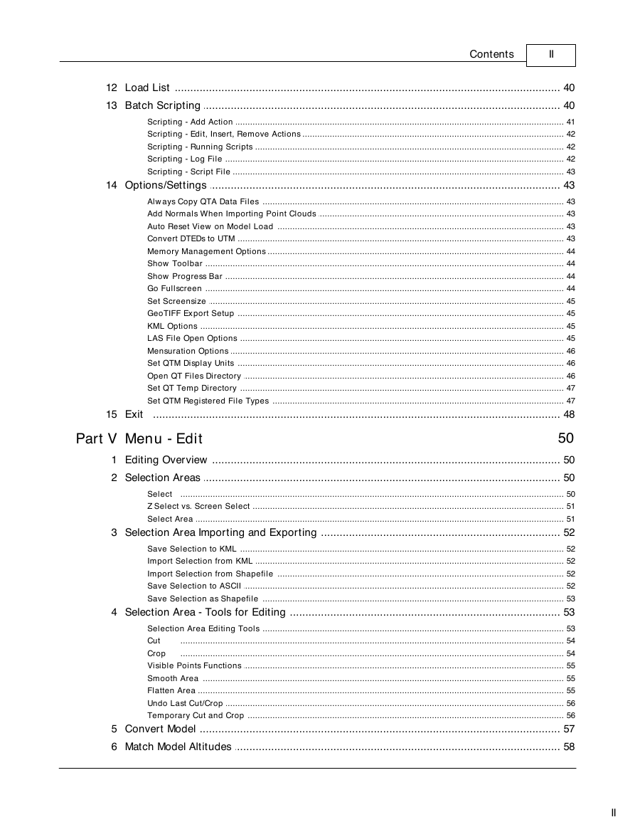
Load List
Batch Scripting
Scripting - Add Action
Scripting - Edit, Insert, Remove Actions
Scripting - Running Scripts
Scripting - Log File
Scripting - Script File
Options/Settings
Always Copy QTA Data Files
Add Normals When Importing Point Clouds
Auto Reset View on Model Load
Convert DTEDs to UTM
Memory Management Options
Show Toolbar
Show Progress Bar
Go Fullscreen
Set Screensize
GeoTIFF Export Setup
KML Options
LAS File Open Options
Mensuration Options
Set QTM Display Units
Open QT Files Directory
Set QT Temp Directory
Set QTM Registered File Types
Exit
Menu - Edit
Editing Overview
Selection Areas
Select
Z Select vs. Screen Select
Select Area
Selection Area Importing and Exporting
Save Selection to KML
Import Selection from KML
Import Selection from Shapefile
Save Selection to ASCII
Save Selection as Shapefile
Selection Area - Tools for Editing
Selection Area Editing Tools
Cut
Crop
Visible Points Functions
Smooth Area
Flatten Area
Undo Last Cut/Crop
Temporary Cut and Crop
Convert Model
Match Model Altitudes
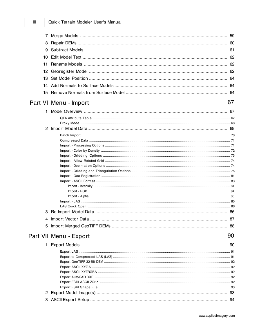
Merge Models
Repair DEMs
Subtract Models
Edit Model Text
Rename Models
Georegister Model
Set Model Position
Add Normals to Surface Models
Remove Normals from Surface Model
Menu - Import
Model Overview
QTA Attribute Table
Proxy Mode
Import Model Data
Batch Import
Compressed Data
Import - Processing Options
Import - Color by Density
Import - Gridding Options
Import - Allow Rotated Grid
Import - Decimation Options
Import - Gridding and Triangulation Options
Import - Geo-Registration
Import - ASCII Format
Import - Intensity
Import - RGB
Import - Alpha
Import - LAS
LAS Quick Open
Re-Import Model Data
Import Vector Data
Import Merged GeoTIFF DEMs
Menu - Export
Export Models
Export LAS
Export to Compressed LAS (LAZ)
Export GeoTIFF 32-Bit DEM
Export ASCII XYZIA
Export ASCII XYZRGBA
Export AutoCAD DXF
Export ESRI ASCII ZGrid
Export ESRI Shape File
Export Model Image(s)
ASCII Export Setup
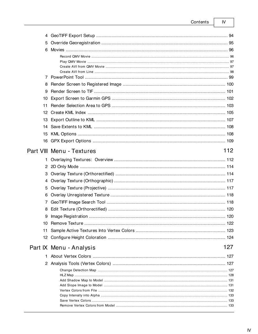
GeoTIFF Export Setup
Override Georegistration
Movies
Record QMV Movie
Play QMV Movie
Create AVI from QMV Movie
Create AVI from Line
PowerPoint Tool
Render Screen to Registered Image
Render Screen to TIF
Export Screen to Garmin GPS
Render Selection Area to GPS
Create KML Index
Export Outline to KML
Save Extents to KML
KML Options
GPX Export Options
Menu - Textures
Overlaying Textures: Overview
2D Only Mode
Overlay Texture (Orthorectified)
Overlay Texture (Orthographic)
Overlay Texture (Projective)
Overlay Unregistered Texture
GeoTIFF Image Search Tool
Edit Texture (Orthorectified)
Image Registration
Remove Texture
Sample Active Textures Into Vertex Colors
Configure Height Coloration
Menu - Analysis
About Vertex Colors
Analysis Tools (Vertex Colors)
Change Detection Map
HLZ Map
Add Shadow Map to Model
Add Slope Image to Model
Vertex Colors from File
Copy Intensity into Alpha
Save Vertex Colors
Remove Vertex Colors from Model
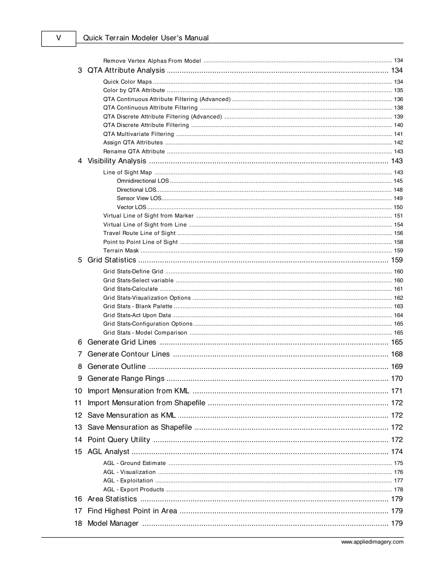
Remove Vertex Alphas From Model
QTA Attribute Analysis
Quick Color Maps
Color by QTA Attribute
QTA Continuous Attribute Filtering (Advanced)
QTA Continuous Attribute Filtering
QTA Discrete Attribute Filtering (Advanced)
QTA Discrete Attribute Filtering
QTA Multivariate Filtering
Assign QTA Attributes
Rename QTA Attribute
Visibility Analysis
Line of Sight Map
Omnidirectional LOS
Directional LOS
Sensor View LOS
Vector LOS
Virtual Line of Sight from Marker
Virtual Line of Sight from Line
Travel Route Line of Sight
Point to Point Line of Sight
Terrain Mask
Grid Statistics
Grid Stats-Define Grid
Grid Stats-Select variable
Grid Stats-Calculate
Grid Stats-Visualization Options
Grid Stats - Blank Palette
Grid Stats-Act Upon Data
Grid Stats-Configuration Options
Grid Stats - Model Comparison
Generate Grid Lines
Generate Contour Lines
Generate Outline
Generate Range Rings
Import Mensuration from KML
Import Mensuration from Shapefile
Save Mensuration as KML
Save Mensuration as Shapefile
Point Query Utility
AGL Analyst
AGL - Ground Estimate
AGL - Visualization
AGL - Exploitation
AGL - Export Products
Area Statistics
Find Highest Point in Area
Model Manager
Model Statistics
Volume Calculations
Filtering
Set Alpha Filtering
Set Change Detection Filtering
Set Clipping Plane
QTA Continuous Filtering
Clear All Filters
Set Water Level
Menu - Display
Display - Show/Hide
Show/Hide Models
Show/Hide Textures
Use Height Coloration
Hide Markers
Display - Options
Use Compressed Normals
Shiny Terrain
Smooth Normals
Show Wireframe
Stereo Display Settings
Show XYZ Axes
Show Compass
Show Crosshairs
Show Haze
Show Legend
Show Light
Show Minimap
Show Model Names/Outlines
Show Sky
Set Display Units
Display - Settings
Cloud Point Settings
DisplaySettingsMensurationOptions
Set Background Color
Set Haze Distance
Set Height Scale
Set Lighting
Set Vector Line Size
Layer Opacity Control
Set Base Model Color
Status Bar Options
Toggle Clouds/Surface
Autocolor Model
Configure Vector Models
Remove Model Colors
Layer Transparency
Menu - Control
Edit Camera Settings
Face Center
Go to Point
Point to Point Viewing
Reset Viewer
Control Mode
Constant Altitude
Flight Mode
Model Mode
Terrain Following
Targeted Point
Enforce Collisions
Independent Rotation
Orbit Mode
Google Earth Style Zoom
Synchronize Google Earth
Display Mode
Display Mode 2D
Display Mode 3D
Control - Options
Set Framerate
Set Moving Speed
Load View/Position
Save View/Position
Menu - Markers
Place Marker
Create Marker
Create at Point
Edit Marker
Marker - Sensor Model
Import Markers
Load Marker
Markers - Import from ASCII File
Markers - Import from CSV File
Import Marker from KML
Markers - Import from SHP File
Export Markers
Export Marker to KML
Save Markers
Remove Markers
Hide All Markers
Inspect Markers
Show/Hide Markers
Edit Route
Export Mission
Save Mission
Load Mission
Marker Options
Marker Options Individual
Markers - Billboards
Marker Point and Click
Measurement Line and Associated Tools
Place Measurement Line
Edit Measurement Line
Recover Measurement Line
Measurement Line Display Preferences
Profile Analysis Tool
Profile Buffer Settings
Profile Y Axis Attribute Selection
Profile Display Points vs Lines
Profile Color Scheme
Profile Cursor Position Display
Profile Model List
Profile Outline Area in 3D
Profile Mask to Area in 3D
Profile Push Buffer to Selection
Profile Mark Cursor in 3D
Profile Zooming Tools
Profile Force Proportional Scaling
Profile Measurement Tool
Profile Configure Appearance
Profile PowerPoint Export
Profile Editing Tools
Profile Edit Select Area
Profile Edit Select Points
Profile Edit Unselect Points
Profile Edit Hide Points 3D
Profile Edit Highlight Points 3D
Profile Edit Operate on Points
Travel Route Analysis Tool
Cross Section Tool
Measurement Vector Info
Measurement Endpoint Info
Vector Annotation
Point Interrogation Utility
Applied Imagery Contact Information


 2023年江西萍乡中考道德与法治真题及答案.doc
 2012年重庆南川中考生物真题及答案.doc
 2013年江西师范大学地理学综合及文艺理论基础考研真题.doc
 2020年四川甘孜小升初语文真题及答案I卷.doc
 2020年注册岩土工程师专业基础考试真题及答案.doc
 2023-2024学年福建省厦门市九年级上学期数学月考试题及答案.doc
 2021-2022学年辽宁省沈阳市大东区九年级上学期语文期末试题及答案.doc
 2022-2023学年北京东城区初三第一学期物理期末试卷及答案.doc
 2018上半年江西教师资格初中地理学科知识与教学能力真题及答案.doc
 2012年河北国家公务员申论考试真题及答案-省级.doc
 2020-2021学年江苏省扬州市江都区邵樊片九年级上学期数学第一次质量检测试题及答案.doc
 2022下半年黑龙江教师资格证中学综合素质真题及答案.doc