Practical Session Instructions
Earth Observation of Water Resources
(SEBS)
Prof. Bob Su & M.Sc. Lichun Wang
ITC, University of Twente
The Netherlands
(July 2013)
�
Contents
Introduction .................................................................................................................... 1
Exercise 1: Preparing MODIS Level 1B data as input for SEBS .................................. 2
1.1 Preparing software for using MODIS products ................................................... 2
1.1.1 HDFView ...................................................................................................... 2
1.1.2 ModisSwathTool ........................................................................................... 2
1.2 Ordering and downloading the data ..................................................................... 3
1.3 Getting familiar with the MODIS data with HDFView tool ............................... 5
Exercise 2: Processing MODIS Level 1B data for use in SEBS for ILWIS .................. 9
2.1 Introduction .......................................................................................................... 9
2.2 Install ILWIS and BEAM software ..................................................................... 9
2.3 Main Processing Steps ....................................................................................... 10
2.3.1 Step I: Reprojecting MODIS Level-1B Data .............................................. 11
2.3.2 Step II: Importing GeoTIFF files into ILWIS raster files ........................... 15
2.3.3 Step III: Pre-processing Tools for SEBS .................................................... 17
2.3.4 Step VI: Running SEBS core module (Surface Energy Balance System) .. 29
2.4 References: ......................................................................................................... 34
Exercise 3: BEAM plug-in for SEBS .......................................................................... 37
3.1 Generating SMAC outputs in BEAM ................................................................ 37
3.2 Generating SEBS outputs .................................................................................. 39
3.2.1 SEBS requested meteorological and radiation input values ....................... 39
3.2.2 SEBS requested satellite input files ............................................................ 40
3.2.3 SEBS Landuse Parameters .......................................................................... 42
3.3 References .......................................................................................................... 43
�
WATER RESOURCES (SEBS)
Exercise 1
Introduction
This practical contains three exercises related to earth observation of water resources.
These exercises were developed originally for the ESA-MOST Dragon programme advanced
training course in land remote sensing.
Exercise 1 deals with the preparation of MODIS Level 1B data as input for SEBS, which
includes preparing software for reading MODIS products, ordering and downloading the
MODIS Level_1B data, and viewing and getting familiar with the MODIS data products in
HDF format.
Exercise 2 leads you though the different steps in processing satellite data (e.g. MODIS
Level-1B data) in the ILWIS system (Integrated Land and Water Information System, an
open source Remote sensing and GIS system developed by ITC, University of Twente,
downloadable from http://www.itc.nl/research_programme, following the ‘ILWIS - Remote
Sensing and GIS software’ link). In a step by step procedure, this exercise enables you to
derive land surface geophysical parameters and energy balance components, including
evaporation rate.
Exercise 3 describes similar steps as in Exercise 2 but using the BEAM software environment
(http://www.brockmann-consult.de/cms/web/beam/). BEAM is an open-source toolbox and
development platform for viewing, analysing and processing of remote sensing raster data.
BEAM supports image data from Envisat's optical instruments, raster data formats such as
GeoTIFF and NetCDF as well as data formats of other EO sensors from MODIS, AVHRR,
AVNIR, PRISM to CHRIS/Proba. Various data and algorithms are supported by dedicated
extension plug-ins. Similarly you go though the different steps in processing satellite data
(e.g. AATSR Level-1B data) to derive surface geophysical parameters and energy balance
components, including evaporation rate by using the SEBS plug-in.
1
�
Exercise 1
WATER RESOURCES (SEBS)
By Lichun Wang, July, 2012
Exercise 1: Preparing MODIS Level 1B data as input for
SEBS
In this exercise we will apply various procedures to estimate evaporation from MODIS L1B
products (L1B is radiometricaly calibrated, but not atmospherically corrected data). The tasks
in this exercise are to perform:
• Preparing the software for MODIS products
• Ordering and downloading the MODIS Level_1B data
• Viewing and Getting familiar with the MODIS data products (HDF datasets) used in
this exercise
1.1 Preparing software for using MODIS products
1.1.1 HDFView
HDFView is a tool for browsing and viewing the contents of HDF files. The software can be
downloaded from http://www.hdfgroup.org/hdf-java-html/hdfview/
If not installed already, installed the package as follows:
1. Type hdfview_install_windows_novm.exe to install
2. Start from Start -> programs -> HDFView 2.8 -> HDFView 2.8
Note: Before the installation of the software, Java JDK1.5.0 (or higher) must be installed
on your machine.
1.1.2 ModisSwathTool
The Modis Reprojection Tool Swath allows you to reproject swath MODIS level-1 and level-
2 data products. It is free and can be obtained from:
http://lpdaac.usgs.gov/landdaac/tools/mrtswath/index.asp
In this exercise, assuming you have downloaded the software as the zip file MRTSwath.zip.
1. Unzip the MRTSwath software to a folder, for example, D:\MRTSwath directory.
2. Edit the ModisSwathTool.bat file in D:\MRTSwath\bin directory. You will need to
update the MRTDATADIR to the MRTSwath data directory, the path to the Java
executable, and the path to the ModisSwathTool.jar file. For example, the Java
executable path is C:\Program Files\Java\jre1.5.0_11\bin, and the MRTSwath is
installed in the D:\MRTSwath directory, the sample ModisSwathTool.bat file looks
like as follows:
-
-
set MRTDATADIR=D:\MRTSwath\data
"c:\WINDOWS\system32\java.exe" –classpath
"D:\MRTSwath\bin\ModisSwathTool.jar" mrtswath.ModisSwathTool
Note that the blue statement is all on one line. Do not break this statement into
multiple lines!
2
�
Exercise 1
WATER RESOURCES (SEBS)
3. Start MRTSwath with ModisSwathTool.bat from the D:\MRTSwath\bin directory, or
to create a shortcut to MRTSwath, and click on the shortcut.
1.2 Ordering and downloading the data
For this exercise, you will be using the following MODIS products, covering the Naqu site on
the Tibetan plateau, China:
MODIS calibrated L1B swath file:
MODIS L1B file MOD021KM.A2008186.0430.005.2010188194504.hdf
Geolocation L1A file:
MOD03.A2008186.0430.005.2008186113434.hdf
Corresponding to an overpass on July 4, 2008 (Julian day186), recorded at 04:30 GMT.
You can order these products from NASA’s LAADS Web:
http://ladsweb.nascom.nasa.gov/browse_images
Figure 1.1 Overview of the web page for MODIS data downloads
For downloading MODIS L1B product, Clicking on DATA filed, then clicking on Search for
MODIS level 1, atmosphere and land products.
The page that corresponds to this selection is shown in the picture below:
3
�
Exercise 1
WATER RESOURCES (SEBS)
Figure 1.2 Overview of MODIS data search
Select the following options for:
Satellite/Instrument:
Terra MODIS
Group:
Terra Level 1 Products
Products
MOD021KM – Level 1B Calibrated Radiances – 1km
MOD03 – Geolocation – 1km
Search Date and Time
Start Date and Time: 04/07/2008 Time (UTC): 04:00:00
End Date and Time: 04/07/2008 Time (UTC): 05:00:00
Collection Selection
5 or 51
Special Selection
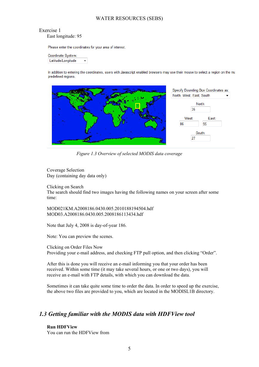
Latitude/Longitude
Search Area
Type in Lat/Lon range
Northern latitude: 35
Southern latitude: 27
West longitude: 86
4
�
WATER RESOURCES (SEBS)
Exercise 1
East longitude: 95
Figure 1.3 Overview of selected MODIS data coverage
Coverage Selection
Day (containing day data only)
Clicking on Search
The search should find two images having the following names on your screen after some
time:
MOD021KM.A2008186.0430.005.2010188194504.hdf
MOD03.A2008186.0430.005.2008186113434.hdf
Note that July 4, 2008 is day-of-year 186.
Note: You can preview the scenes.
Clicking on Order Files Now
Providing your e-mail address, and checking FTP pull option, and then clicking “Order”.
After this is done you will receive an e-mail informing you that your order has been
received. Within some time (it may take several hours, or one or two days), you will
receive an e-mail with FTP details, with which you can download the data.
Sometimes it can take quite some time to order the data. In order to speed up the exercise,
the above two files are provided to you, which are located in the MODISL1B directory.
1.3 Getting familiar with the MODIS data with HDFView tool
Run HDFView
You can run the HDFView from
5
�
WATER RESOURCES (SEBS)
Exercise 1
Start->Program Files->HDFView2.8
Open a file:
You can either click the “open” button or select the “open” from the file menu. In the
Open file pop up window, choose this file
MOD021KM.A2008186.0430.005.2010188194504.hdf
After you open this file, the structure of the file is displayed in the tree panel on the left
side of the Main Window.
View data content:
Double click “MODIS_SWATH_Type_L1B”, and then double click “Data Fields” to see
the content of the data fields (see picture below).
Figure 1.4 Overview of the tree panel of the Main Window
Examine the band attributes of the file:
To view the attributes of data fields, you can right click an individual field e.g.
EV_250_Agg1km_RefSB, in the context-menu, then select “Show Properties” menu,
then in the pop up window, click on Attributes tab. The following figure shows an
example of the information of the selected data field.
6
�




 2023年江西萍乡中考道德与法治真题及答案.doc
 2012年重庆南川中考生物真题及答案.doc
 2013年江西师范大学地理学综合及文艺理论基础考研真题.doc
 2020年四川甘孜小升初语文真题及答案I卷.doc
 2020年注册岩土工程师专业基础考试真题及答案.doc
 2023-2024学年福建省厦门市九年级上学期数学月考试题及答案.doc
 2021-2022学年辽宁省沈阳市大东区九年级上学期语文期末试题及答案.doc
 2022-2023学年北京东城区初三第一学期物理期末试卷及答案.doc
 2018上半年江西教师资格初中地理学科知识与教学能力真题及答案.doc
 2012年河北国家公务员申论考试真题及答案-省级.doc
 2020-2021学年江苏省扬州市江都区邵樊片九年级上学期数学第一次质量检测试题及答案.doc
 2022下半年黑龙江教师资格证中学综合素质真题及答案.doc