Agricultural Sciences, 2017, 8, 729-742
http://www.scirp.org/journal/as
ISSN Online: 2156-8561
ISSN Print: 2156-8553
Cost Effectiveness of Growing Cotton
Depending on Irrigation Source and
Groundwater Salinity in the Ferghana
Valley, Uzbekistan
Sherzod Muminov, Galina Stulina, Islom Rusiev
International Fund for the Aral Sea Saving, Interstate Coordination Water Commission, Scientific-Information Center, Tashkent,
Uzbekistan
How to cite this paper: Muminov, S.,
Stulina, G. and Rusiev, I. (2017) Cost Effec-
tiveness of Growing Cotton Depending on
Irrigation Source and Groundwater Salinity
in the Ferghana Valley, Uzbekistan. Agri-
cultural Sciences, 8, 729-742.
https://doi.org/10.4236/as.2017.88054
Received: June 15, 2017
Accepted: August 5, 2017
Published: August 8, 2017
Copyright © 2017 by authors and
Scientific Research Publishing Inc.
This work is licensed under the Creative
Commons Attribution International
License (CC BY 4.0).
http://creativecommons.org/licenses/by/4.0/
Open Access
Abstract
Given article describes the current status of irrigated agriculture in the Ferg-
hana province, Republic of Uzbekistan. Climatic, hydrogeological, and soil
conditions and hydromodule zoning of the Water User Association (WUA)
Oktepa Zilol were studied, and, on this basis, the farms growing cotton were
selected. Variable and fixed costs and profitability of cotton-growing farms
were analyzed. Based on the books of those farms, the crop budget was drawn
up. Relationships between the profitability of cotton-growing farm and the ir-
rigation sources used and soil fertility in the farm are explained. Finally, pro-
posals for improvement of cotton production using various sources of irriga-
tion under different degrees of groundwater salinity are provided.
Keywords
Irrigation, Groundwater, Drainage Water, Salinity, Costs, Revenue
1. Introduction
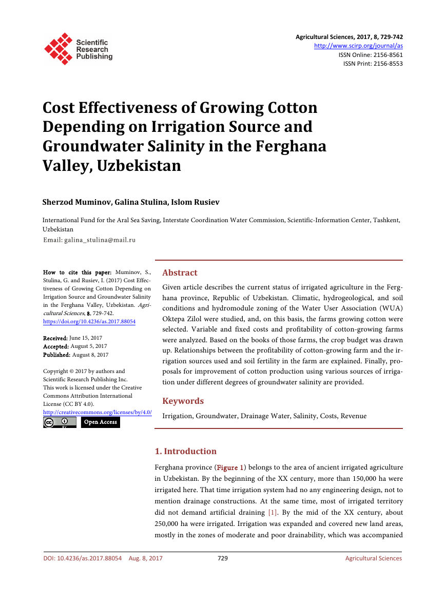
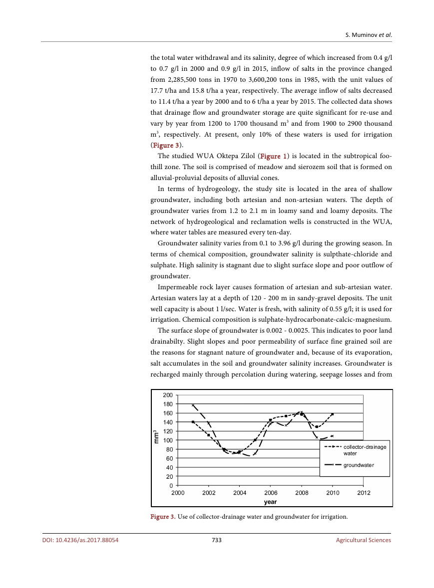
Ferghana province (Figure 1) belongs to the area of ancient irrigated agriculture
in Uzbekistan. By the beginning of the XX century, more than 150,000 ha were
irrigated here. That time irrigation system had no any engineering design, not to
mention drainage constructions. At the same time, most of irrigated territory
did not demand artificial draining [1]. By the mid of the XX century, about
250,000 ha were irrigated. Irrigation was expanded and covered new land areas,
mostly in the zones of moderate and poor drainability, which was accompanied
DOI: 10.4236/as.2017.88054 Aug. 8, 2017
729
Agricultural Sciences
�
S. Muminov et al.
Figure 1. WUA Oktepa Zilol, Ferghana province.
by construction of inter- and rare on-farm collectors. However, such construc-
tion lacked primary relief drains; consequently, secondary salinization developed
in case of shallow saline groundwater.
Development of adyr soil increased contribution from groundwater in the
lower land. Thus, land conditions got worse. To prevent secondary salinization,
vertical and horizontal drainage system was designed and constructed. 188,000
ha were equipped with drainage (67.5% of irrigated area) in 1970, 261,000 ha
(73.2%) in 2000, and 265,000 ha (70%) in 2010. Main draining tracts in the
province are the Achchikkul collector with the flow rate of 53 m3/sec, P-3 col-
lector—21.2 m3/sec, Shimoliy collector—17.7 m3/sec, Naynova collector—11.8
m3/sec, Sokh Isfara collector—12.5 m3/sec, К-4 collector—8.8 m3/sec, and Sari
Juga collector—3.8 m3/sec [2].
In 2015, cotton was grown on an area of 100,100 ha in the Ferghana province,
with the average cotton yield reaching 28.6 centner/ha or 2.3 centner/ha lower
than in 1991 [3]. The main cause of yield reduction is the higher level of drai-
nage water salinity that resulted in salinization of land in the drained area.
Given the conditions of water scarcity and limitation, there is a need to use
drainage water or its mixture with river-water for irrigation [4]. This practice
has become especially important in the recent time due to climate change and
730
Agricultural Sciences
DOI: 10.4236/as.2017.88054
�
S. Muminov et al.
severe droughts and has a direct effect on cost effectiveness of cotton produc-
tion.
2. Research Object
Given research was carried out as part of the ICARDA Project (Project No.
1374) “Evaluate the effect of conjunctive use of canal and drainage water, differ-
ent cropping patterns, and improved irrigation practices on control of salinity
and waterlogging and delineate most efficient water management and agronom-
ic practices” in the Ferghana province, Uzbekistan during As pilot sites the
farms growing cotton were selected within the Water User Association (WUA)
Oktepa Zilol located in Kushtepa district of Ferghana province. Researches and
the analysis of results were carried out in 2014-2016.
2.1. Climatic Conditions
The climate in the region is sharply continental and dry with abundant heat and
sunshine. Temperature regime is positive, with the average annual temperature
of 13.9˚C. The coldest month is January with the average monthly temperature
−0.7˚C and the absolute minimum temperature −28˚C. The hottest month is Ju-
ly with the average monthly temperature +27.3˚C and the absolute maximum
temperature +43.5˚C. The rest of the year, but January and February, is with
positive temperatures. The frost-free season lasts for 227 days. The region is very
arid.
In 2015, the maximum of +32˚C was recorded in Andizhan weather station.
Winter was not severe and the temperature did not fall below +5˚C.
The non-growing season is characterized by high precipitation. The growing
season is least humid, 57.2 mm; most precipitation falls in April and May in the
amount of 18 - 19 mm, and minimum precipitation is recorded in July and Au-
gust at 2 - 4 mm.
There is heavy shower or hail in spring. That causes mudflow in adyrs, foo-
thills and highlands. Snow pack is unstable. Snow pack lasts for 29 days. Pro-
longed heavy fog, hoarfrost, and ice-covered land are also typical for winter
months. The average monthly wind speed is from 1.7 to 3.6 m/sec. The maxi-
mum wind speed amounts to 10 - 15 m/sec and sometimes more than 15 m/sec.
In 2015, wind regime was within the average annual indicators.
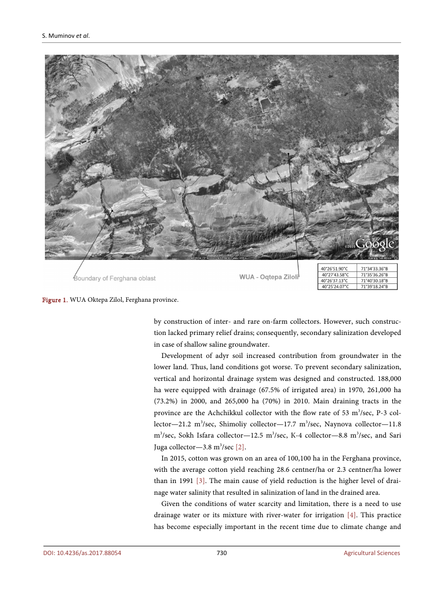
In the study region, evapotranspiration—total evaporation from free water
surface and transpiration-amounts to 900 mm (Figure 2).
Air humidity deficit and high temperatures cause increased evaporation in
summer. Thus, owing to high dryness in this region, agriculture may be devel-
oped only under artificial irrigation.
2.2. Hydrogeological Conditions
Geomorphologic conditions determined specific hydrogeological situation in
Ferghana province: formation of high-pressure artesian water with inflow from
731
Agricultural Sciences
DOI: 10.4236/as.2017.88054
�
S. Muminov et al.
DOI: 10.4236/as.2017.88054
Figure 2. Potential evapotraspiration data, WUA Oktepa Zilol, Ferghana province.
the surrounding mountains and also saline shallow groundwater. Before the de-
velopment of drainage systems, water table was up to 2 m everywhere, and the
salinity of groundwater varied from 3 - 5 to 10 g/l and more. Piezometric heads
are at the level of 0.2 - 0.95 m above water table everywhere. Groundwater re-
charge through overflow from confined aquifer in quaternary deposits of Central
Ferghana varies from 2 - 3 to 8 - 10 thousand m3/ha. Thus, groundwater is shal-
low, and substantial drainage flow is formed, i.e. drainage capacity increases.
In terms of natural drainability, the area of Central Ferghana is divided into 5
zones with:
-
Intensive drainability. This zone spreads over foothill side, with deep ground-
water;
- Moderate drainability. This zone spreads over upstream of the Big Fergana
Canal (BFC) in the western part of the province;
- Poor drainability. This zone spreads between BFC and SFC;
- Very poor drainability. This zone spreads over central part of the province
downstream of the BFC; and
- Drainless zone. This zone spreads over floodplain zone of the Syrdarya River.
Ferghana province has rather long unit length (24 - 41 m/ha per irrigated
area) of subsurface drainage in 1970-2015. Alongside with horizontal drainage,
vertical drainage wells were actively constructed and increased from 100 wells in
1970 and 1303 ones in 1995. However, their quantity dropped to 1131 in 2010
[1] [4] and even to 554 in 2015. In 2015, 38 vertical drainage wells were available
in Kushtepa district.
This massive system of vertical and horizontal drainage provided substantial
drainage salt-water outflow. In 1970-1975, the total drainage flow amounted to
about 2554 Mm3, while water withdrawal was 5078 Mm3. Since 1980, drainage
flow has got more or less stabilized at the level of 3000 Mm3 per year, while the
total water withdrawal was 5000 Mm3 per year. By 2000-2015, both water with-
drawal and the total drainage flow have decreased.
The share of the total drainage flow in water withdrawal of the Ferghana
province varied from 40.7% in 1970 to 50.4% in 2000 and 58.1% in 2015. Given
732
Agricultural Sciences
�
S. Muminov et al.
the total water withdrawal and its salinity, degree of which increased from 0.4 g/l
to 0.7 g/l in 2000 and 0.9 g/l in 2015, inflow of salts in the province changed
from 2,285,500 tons in 1970 to 3,600,200 tons in 1985, with the unit values of
17.7 t/ha and 15.8 t/ha a year, respectively. The average inflow of salts decreased
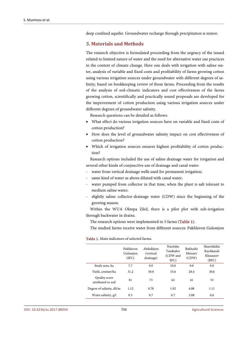
to 11.4 t/ha a year by 2000 and to 6 t/ha a year by 2015. The collected data shows
that drainage flow and groundwater storage are quite significant for re-use and
vary by year from 1200 to 1700 thousand m3 and from 1900 to 2900 thousand
m3, respectively. At present, only 10% of these waters is used for irrigation
(Figure 3).
The studied WUA Oktepa Zilol (Figure 1) is located in the subtropical foo-
thill zone. The soil is comprised of meadow and sierozem soil that is formed on
alluvial-proluvial deposits of alluvial cones.
In terms of hydrogeology, the study site is located in the area of shallow
groundwater, including both artesian and non-artesian waters. The depth of
groundwater varies from 1.2 to 2.1 m in loamy sand and loamy deposits. The
network of hydrogeological and reclamation wells is constructed in the WUA,
where water tables are measured every ten-day.
Groundwater salinity varies from 0.1 to 3.96 g/l during the growing season. In
terms of chemical composition, groundwater salinity is sulpthate-chloride and
sulphate. High salinity is stagnant due to slight surface slope and poor outflow of
groundwater.
Impermeable rock layer causes formation of artesian and sub-artesian water.
Artesian waters lay at a depth of 120 - 200 m in sandy-gravel deposits. The unit
well capacity is about 1 l/sec. Water is fresh, with salinity of 0.55 g/l; it is used for
irrigation. Chemical composition is sulphate-hydrocarbonate-calcic-magnesium.
The surface slope of groundwater is 0.002 - 0.0025. This indicates to poor land
drainabilty. Slight slopes and poor permeability of surface fine grained soil are
the reasons for stagnant nature of groundwater and, because of its evaporation,
salt accumulates in the soil and groundwater salinity increases. Groundwater is
recharged mainly through percolation during watering, seepage losses and from
Figure 3. Use of collector-drainage water and groundwater for irrigation.
733
Agricultural Sciences
DOI: 10.4236/as.2017.88054
�
S. Muminov et al.
DOI: 10.4236/as.2017.88054
deep confined aquifer. Groundwater recharge through precipitation is minor.
3. Materials and Methods
The research objective is formulated proceeding from the urgency of the issued
related to limited nature of water and the need for alternative water use practices
in the context of climate change. Here one deals with irrigation with saline wa-
ter, analysis of variable and fixed costs and profitability of farms growing cotton
using various irrigation sources under groundwater with different degrees of sa-
linity, based on bookkeeping review of those farms. Proceeding from the results
of the analysis of soil-climatic indicators and cost effectiveness of the farms
growing cotton, scientifically and practically sound proposals are developed for
the improvement of cotton production using various irrigation sources under
different degrees of groundwater salinity.
Research questions can be detailed as follows:
• What effect do various irrigation sources have on variable and fixed costs of
cotton production?
• How does the level of groundwater salinity impact on cost effectiveness of
cotton production?
• Which of irrigation sources ensures highest profitability of cotton produc-
tion?
Research options included the use of saline drainage water for irrigation and
several other kinds of conjunctive use of drainage and canal water:
- water from vertical drainage wells used for permanent irrigation;
- same kind of water as above diluted with canal water;
- water pumped from collector in that time, when the plant is salt tolerant to
medium saline water;
- slightly saline collector-drainage water (CDW) since the beginning of the
growing season.
Within the WUA Oktepa Zilol, there is a pilot plot with sub-irrigation
through backwater in drains.
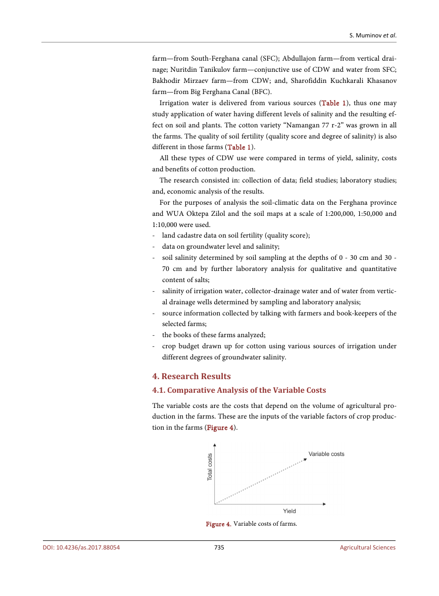
The research options were implemented in 5 farms (Table 1).
The studied farms receive water from different sources: Pakhlavon Gulomjon
Table 1. Main indicators of selected farms.
Pakhlavon
Gulomjon
(SFC)
Abdullajon
(vertical
drainage)
Study area, ha
Yield, centner/ha
Quality score
attributed to soil
Degree of salinity, dS/m
Water salinity, g/l
7.7
31.2
81
1.12
0.5
9.0
30.0
73
0.78
0.7
Nuritdin
Tanikulov
(CDW and
SFC)
10.0
33.6
62
1.92
0.7
Bakhodir
Mirzaev
(CDW)
9.0
28.4
41
4.88
3.88
Sharofiddin
Kuchkarali
Khasanov
(BFC)
9.0
30.6
53
1.11
0.6
734
Agricultural Sciences
�
S. Muminov et al.
farm—from South-Ferghana canal (SFC); Abdullajon farm—from vertical drai-
nage; Nuritdin Tanikulov farm—conjunctive use of CDW and water from SFC;
Bakhodir Mirzaev farm—from CDW; and, Sharofiddin Kuchkarali Khasanov
farm—from Big Ferghana Canal (BFC).
Irrigation water is delivered from various sources (Table 1), thus one may
study application of water having different levels of salinity and the resulting ef-
fect on soil and plants. The cotton variety “Namangan 77 r-2” was grown in all
the farms. The quality of soil fertility (quality score and degree of salinity) is also
different in those farms (Table 1).
All these types of CDW use were compared in terms of yield, salinity, costs
and benefits of cotton production.
The research consisted in: collection of data; field studies; laboratory studies;
and, economic analysis of the results.
land cadastre data on soil fertility (quality score);
For the purposes of analysis the soil-climatic data on the Ferghana province
and WUA Oktepa Zilol and the soil maps at a scale of 1:200,000, 1:50,000 and
1:10,000 were used.
-
- data on groundwater level and salinity;
- soil salinity determined by soil sampling at the depths of 0 - 30 cm and 30 -
70 cm and by further laboratory analysis for qualitative and quantitative
content of salts;
- salinity of irrigation water, collector-drainage water and of water from vertic-
al drainage wells determined by sampling and laboratory analysis;
- source information collected by talking with farmers and book-keepers of the
selected farms;
the books of these farms analyzed;
-
- crop budget drawn up for cotton using various sources of irrigation under
different degrees of groundwater salinity.
4. Research Results
4.1. Comparative Analysis of the Variable Costs
The variable costs are the costs that depend on the volume of agricultural pro-
duction in the farms. These are the inputs of the variable factors of crop produc-
tion in the farms (Figure 4).
DOI: 10.4236/as.2017.88054
Figure 4. Variable costs of farms.
735
Agricultural Sciences
�
S. Muminov et al.
Variable costs of the farms include:
- seeds cost;
- mineral and organic fertilizer costs;
- agrochemicals;
-
- machine and equipment repair and maintenance;
-
- remuneration of hired workers and farm workers who are busy with harvest-
transportation of products;
fuels and lubricants;
ing and other kinds of activities related to the use of resources.
The variable costs always grow as the scale of production increases.
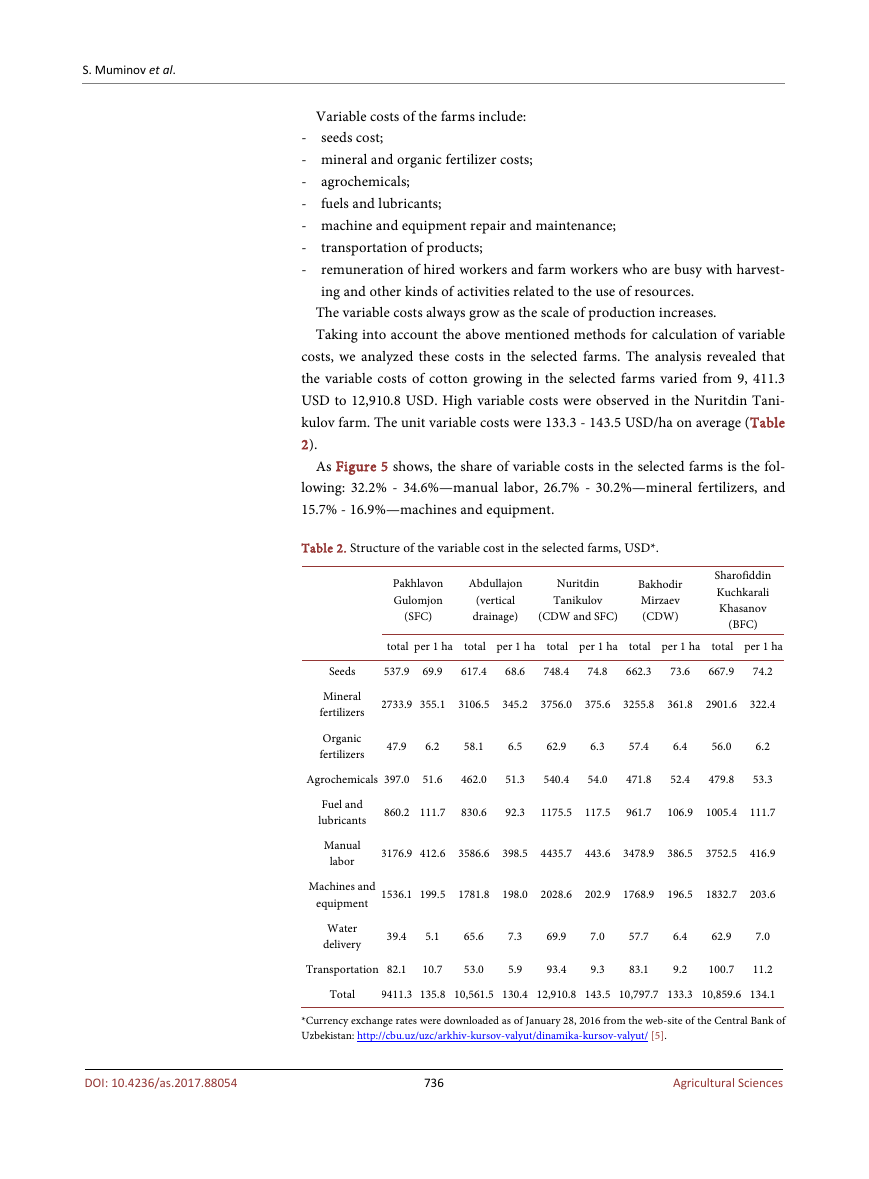
Taking into account the above mentioned methods for calculation of variable
costs, we analyzed these costs in the selected farms. The analysis revealed that
the variable costs of cotton growing in the selected farms varied from 9, 411.3
USD to 12,910.8 USD. High variable costs were observed in the Nuritdin Tani-
kulov farm. The unit variable costs were 133.3 - 143.5 USD/ha on average (Table
2).
As Figure 5 shows, the share of variable costs in the selected farms is the fol-
lowing: 32.2% - 34.6%—manual labor, 26.7% - 30.2%—mineral fertilizers, and
15.7% - 16.9%—machines and equipment.
Table 2. Structure of the variable cost in the selected farms, USD*.
Pakhlavon
Gulomjon
(SFC)
Аbdullajon
(vertical
drainage)
Nuritdin
Tanikulov
(CDW and SFC)
Bakhodir
Mirzaev
(CDW)
Sharofiddin
Kuchkarali
Khasanov
(BFC)
total per 1 ha
total per 1 ha
total per 1 ha
total per 1 ha
total per 1 ha
Seeds
537.9 69.9
617.4
68.6
748.4
74.8
662.3
73.6
667.9
74.2
Mineral
fertilizers
Organic
fertilizers
2733.9 355.1 3106.5 345.2 3756.0 375.6 3255.8 361.8 2901.6 322.4
47.9
6.2
58.1
6.5
62.9
6.3
57.4
6.4
56.0
6.2
Agrochemicals 397.0 51.6
462.0
51.3
540.4
54.0
471.8
52.4
479.8
53.3
Fuel and
lubricants
Manual
labor
860.2 111.7
830.6
92.3
1175.5 117.5
961.7
106.9 1005.4 111.7
3176.9 412.6 3586.6 398.5 4435.7 443.6 3478.9 386.5 3752.5 416.9
Machines and
equipment 1536.1 199.5 1781.8 198.0 2028.6 202.9 1768.9 196.5 1832.7 203.6
Water
delivery
65.6
69.9
39.4
5.1
62.9
7.0
7.3
7.0
57.7
6.4
Transportation 82.1
10.7
53.0
5.9
93.4
9.3
83.1
9.2
100.7
11.2
Total
9411.3 135.8 10,561.5 130.4 12,910.8 143.5 10,797.7 133.3 10,859.6 134.1
*Currency exchange rates were downloaded as of January 28, 2016 from the web-site of the Central Bank of
Uzbekistan: http://cbu.uz/uzc/arkhiv-kursov-valyut/dinamika-kursov-valyut/ [5].
736
Agricultural Sciences
DOI: 10.4236/as.2017.88054
�


 2023年江西萍乡中考道德与法治真题及答案.doc
 2012年重庆南川中考生物真题及答案.doc
 2013年江西师范大学地理学综合及文艺理论基础考研真题.doc
 2020年四川甘孜小升初语文真题及答案I卷.doc
 2020年注册岩土工程师专业基础考试真题及答案.doc
 2023-2024学年福建省厦门市九年级上学期数学月考试题及答案.doc
 2021-2022学年辽宁省沈阳市大东区九年级上学期语文期末试题及答案.doc
 2022-2023学年北京东城区初三第一学期物理期末试卷及答案.doc
 2018上半年江西教师资格初中地理学科知识与教学能力真题及答案.doc
 2012年河北国家公务员申论考试真题及答案-省级.doc
 2020-2021学年江苏省扬州市江都区邵樊片九年级上学期数学第一次质量检测试题及答案.doc
 2022下半年黑龙江教师资格证中学综合素质真题及答案.doc