DSAS 4.0
Installation Instructions and User Guide
* updated for version 4.3 (only compatible with ArcGIS 10)
U.S. Department of the Interior
U.S. Geological Survey
In cooperation with Innovate! Inc.
http://www.innovateteam.com
Himmelstoss, E.A. 2009. “DSAS 4.0 Installation Instructions and User Guide” in: Thieler, E.R., Himmelstoss, E.A.,
Zichichi, J.L., and Ergul, Ayhan. 2009 Digital Shoreline Analysis System (DSAS) version 4.0 — An ArcGIS
extension for calculating shoreline change: U.S. Geological Survey Open-File Report 2008-1278. *updated for
version 4.3.
�
Contents
1
Introduction .................................................................................................................................................................. 4
1.1 Overview ............................................................................................................................................................... 4
1.2 System Requirements......................................................................................................................................... 4
2
Installation Steps ......................................................................................................................................................... 5
3 Sample data .................................................................................................................................................................. 6
4 DSAS Toolbar ............................................................................................................................................................... 7
5 Required Inputs ............................................................................................................................................................ 8
5.1 Geodatabase ........................................................................................................................................................ 8
5.1.1 Creating a new geodatabase ...................................................................................................................... 8
5.1.2 Upgrading a preexisting geodatabase ..................................................................................................... 8
5.2 Shorelines ............................................................................................................................................................. 9
5.2.1 Tips for collecting shoreline data ........................................................................................................... 10
5.2.2 Appending shorelines ................................................................................................................................ 11
5.2.3 Shoreline attribute field requirements ................................................................................................... 13
5.3 Baseline .............................................................................................................................................................. 14
5.3.1 Tips for constructing a baseline .............................................................................................................. 14
5.3.2 Baseline attribute field requirements ..................................................................................................... 17
6 DSAS Workflow ......................................................................................................................................................... 19
6.1 Set Default Parameters window .......................................................................................................................... 21
6.1.1 Cast Transect Settings tab ........................................................................................................................ 21
6.1.2 Shoreline Calculation Settings tab ......................................................................................................... 23
6.1.3 Metadata Settings tab ................................................................................................................................ 25
6.1.4 Log File Output ............................................................................................................................................. 26
6.2 Cast Transects ................................................................................................................................................... 27
6.2.1 Using Select Features Tool (baseline) .................................................................................................... 30
6.2.2 Transect Feature Class Attribute Fields ................................................................................................. 31
6.3 Modifying the Transect and Baseline Feature Classes ............................................................................. 32
6.4 Using transects from previous versions of DSAS ....................................................................................... 35
6.5 Calculating Change Statistics ......................................................................................................................... 36
6.5.1 Statistical Output......................................................................................................................................... 39
6.5.2 How to View Results Spatially ................................................................................................................. 40
6.6 Clipping transects to the Shoreline Change Envelope (SCE) .................................................................... 41
6.7 Using the Select Features Tool (shoreline) .................................................................................................. 43
7 Statistics ...................................................................................................................................................................... 44
7.1 Shoreline Change Envelope (SCE) ................................................................................................................. 45
7.2 Net Shoreline Movement (NSM) .................................................................................................................... 46
7.3 End Point Rate (EPR) ......................................................................................................................................... 47
7.4 Linear Regression (LRR) ................................................................................................................................... 48
7.5 Weighted Linear Regression (WLR)............................................................................................................... 50
7.6 Supplemental Statistics ................................................................................................................................... 52
7.6.1 Confidence of End Point Rate (ECI) .......................................................................................................... 52
7.6.2 Standard Error of the Estimate (LSE and WSE)...................................................................................... 52
2
�
7.6.3 Standard Error of the Slope with Confidence Interval (LCI and WCI) .............................................. 55
7.6.4 R-squared (LR2 and WR2) .......................................................................................................................... 56
7.7 Least Median of Squares (LMS) ..................................................................................................................... 57
8 External Module Interfacing .................................................................................................................................... 59
8.1 Module Calc File ................................................................................................................................................ 60
8.2 Module Info File ................................................................................................................................................. 62
8.3 Module Input File ............................................................................................................................................... 63
8.4 Module Output File ............................................................................................................................................ 66
9 Metadata ..................................................................................................................................................................... 67
9.1 Configuring ArcGIS to view DSAS-generated metadata ........................................................................... 67
9.2 Editing DSAS-generated Metadata in FGDC format ................................................................................... 69
9.3 Upgrading DSAS-generated Metadata to Arc10 format ............................................................................ 70
10 References .................................................................................................................................................................. 71
11 Appendix 1 – Troubleshooting ................................................................................................................................. 73
12 Appendix 2 – A case study of complex shoreline data ....................................................................................... 74
12.1 Using shoreline data referenced to different proxies ................................................................................ 74
12.2 Representing lidar shorelines as calibrated routes.................................................................................... 75
12.3 Storing bias and uncertainty data in a table (requirements) .................................................................... 77
12.4 Proxy-datum bias correction (NU_ and NB_) .............................................................................................. 78
Contact Information ......................................................................................................................................................... 79
3
�
1
Introduction
1.1 Overview
The Digital Shoreline Analysis System (DSAS) is a freely available software application that
works within the Environmental Systems Research Institute (ESRI) Geographic Information System
(ArcGIS) software. DSAS computes rate-of-change statistics for a time series of shoreline vector data.
Version 4.3 was released in April 2012 and is only compatible with ArcGIS v.10. It is supported on
Windows XP, Vista, and Windows 7 operating systems. If you use it, please cite the following
publication and make note of the current version:
Thieler, E.R., Himmelstoss, E.A., Zichichi, J.L., and Ergul, Ayhan, 2009. Digital Shoreline
Analysis System (DSAS) version 4.0 — An ArcGIS extension for calculating shoreline change:
U.S. Geological Survey Open-File Report 2008-1278. *current version 4.3
This user guide describes the system requirements, installation procedures, and necessary inputs
to establish measurement locations with transects and compute rate-of-change calculations using DSAS.
The DSAS software was developed in the early 1990s. Updates have focused on improving the rate-of-
change statistics as well as the user interface and are designed to be compatible with the current version
of ESRI ArcView software.
Although the nomenclature for this software utility is based on use in a coastal environment, the
DSAS application is also useful for computing rates of change for any boundary-change problem that
incorporates a clearly-identified feature position at discrete times, such as glacier limits, river banks, or
land use/cover boundaries.
1.2 System Requirements
Before installing the DSAS 4.3 application, ensure that your system meets the following software
requirements (note that installation of these applications on your system requires administrative rights):
1. Microsoft .NET Framework 3.5 (or higher).
2. ArcGIS Desktop 10. DSAS is not compatible with ArcGIS v.9.x.
3. .NET Support Feature for ArcGIS (available on ArcGIS installation media).
4. Freely available MATLAB component runtime library utility.
4
�
2
Installation Steps
Important! Before installing DSAS 4.3, the following steps should be taken:
1.
Make sure that the Microsoft .NET Framework 3.5 is installed on your machine.
You should see Microsoft .NET Framework 3.5 Configuration listed in at least one of these
locations:
A. Start>Control Panel>Administrative Tools
or
B. Start>Control Panel>Add/Remove Programs
The .NET Framework downloads are available from the Microsoft web site
www.microsoft.com/downloads
2.
Install the MATLAB Component Runtime (MCR) library utility by double-clicking the
MCRInstaller.exe which can be downloaded from the DSAS web site.
Installation Steps for Digital Shoreline Analysis System 4.3
The application is available for download at the web site (http://woodshole.er.usgs.gov/project-
pages/dsas/).
1. Make sure that you have UNINSTALLED any prior versions of the Digital Shoreline Analysis
System software before installing this version (DSAS 4.3). If your system previously had
ArcGIS 9.x installed and you uninstalled it without first uninstalling DSAS 4.2, you may need to
use the uninstall patch located on the DSAS project page website:
http://woodshole.er.usgs.gov/project-pages/dsas/
2. Make sure that you have CLOSED ALL ARCGIS SOFTWARE running on your local
machine.
3. Extract the .zip file to a preferred location.
4. Highlight the setup.exe application, and double-click to launch the setup wizard.
5. Choose an installation folder.
6. The program should confirm that a successful installation has occurred and require you to click
Close to exit.
5
�
If the DSAS toolbar application is not automatically added to ArcMap, right-click in the toolbar area
and select “DSAS toolbar”.
3 Sample data
A sample dataset for DSAS 4.3 is available for download on the DSAS web site
(http://pubs.usgs.gov/of/2008/1278/). The sample data include four shoreline positions for a section of
the North Carolina coast near Rodanthe along the Outer Banks; these data are a subset of data from
Miller and others, 2005. The shoreline positions from 1842, 1946, and 1980 were digitized from coastal
survey maps, called “T-sheets,” and mark the location of the mean high water line. The shoreline from
09/26/1997 marks the location of the tidal-based operational mean high water line and was extracted
from lidar data following the techniques described in Stockdon and others, 2002, and Weber and others,
2005. The lidar data illustrate how to incorporate shoreline data that include more complex attributes
into DSAS analysis. Advanced users are encouraged to review appendix 2, which describes these data
and their use in DSAS.
The sample data also include a reference baseline from which the DSAS transects are cast. The
sample data are referenced throughout the user guide and have been designed as an example to help
users set up their own data for use in DSAS. The DSAS_sample_data.mdb file is distributed as an
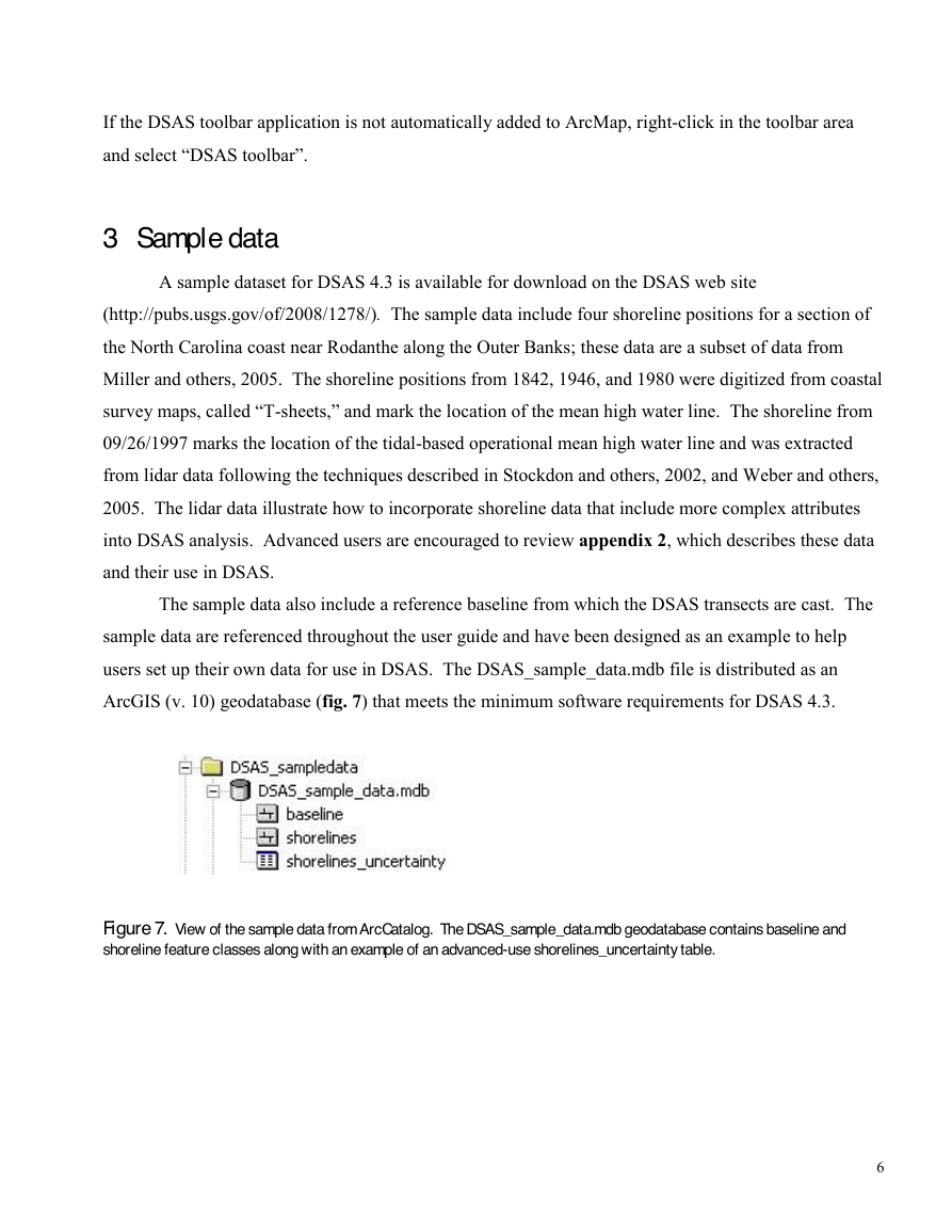
ArcGIS (v. 10) geodatabase (fig. 7) that meets the minimum software requirements for DSAS 4.3.
Figure 7. View of the sample data from ArcCatalog. The DSAS_sample_data.mdb geodatabase contains baseline and
shoreline feature classes along with an example of an advanced-use shorelines_uncertainty table.
6
�
4 DSAS Toolbar
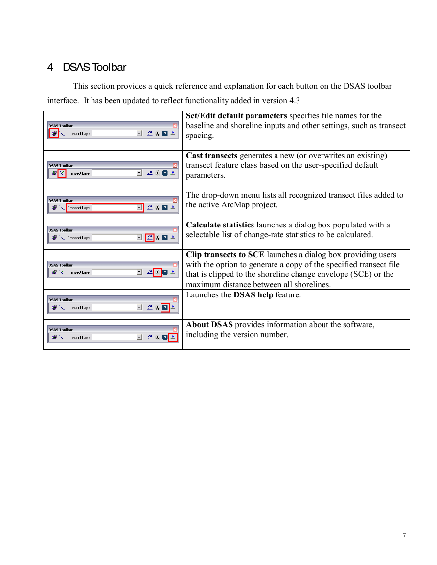
This section provides a quick reference and explanation for each button on the DSAS toolbar
interface. It has been updated to reflect functionality added in version 4.3
Set/Edit default parameters specifies file names for the
baseline and shoreline inputs and other settings, such as transect
spacing.
Cast transects generates a new (or overwrites an existing)
transect feature class based on the user-specified default
parameters.
The drop-down menu lists all recognized transect files added to
the active ArcMap project.
Calculate statistics launches a dialog box populated with a
selectable list of change-rate statistics to be calculated.
Clip transects to SCE launches a dialog box providing users
with the option to generate a copy of the specified transect file
that is clipped to the shoreline change envelope (SCE) or the
maximum distance between all shorelines.
Launches the DSAS help feature.
About DSAS provides information about the software,
including the version number.
7
�
5
Required Inputs
This section describes the data requirements, including file format and field attributes that are
necessary for DSAS to properly recognize and compute rate-of-change statistics. It includes instruction
on how to produce the required files and field elements.
5.1 Geodatabase
All DSAS input data must be managed within a personal geodatabase, which also serves as the
storage location for the program-generated transect feature class and related statistical output tables.
Preexisting data, such as shapefiles, can be imported as feature classes within a geodatabase in
ArcCatalog. The geodatabase not only serves as a storage container for all of the data used and
produced by DSAS but provides a data structure that enables the enforcement of topology, meaning that
spatial relationships among the feature classes can be enforced (this is explained more fully in section
6.3). DSAS also requires that data be in meter units in a projected coordinate system (such as Universal
Transverse Mercator or State Plane).
5.1.1 Creating a new geodatabase
Follow the steps below to create a new personal geodatabase. Once a geodatabase has been
created, existing data can be imported as individual feature classes into a geodatabase within
ArcCatalog. More information can be found using the keywords “importing data geodatabase” in
ArcGIS Desktop Help.
1.
Open ArcCatalog and navigate to the location where you want to store your data in the file tree.
2.
Right-click on the folder where you want the geodatabase to be stored.
3.
Navigate to New > Personal Geodatabase in the popup menu.
5.1.2 Upgrading a preexisting geodatabase
This version of DSAS (4.3) is compatible with ArcGIS 10 only. Each ArcGIS version includes
updates and improved geodatabase capabilities. Geodatabases created in earlier versions of ArcGIS
must be upgraded to the current version. For example, a geodatabase created in ArcGIS 9.3 must be
upgraded before using the data in ArcGIS 10. This can be done in ArcCatalog by right-clicking on the
geodatabase, selecting Properties from the pop-up menu, and clicking on the Upgrade Geodatabase
button as illustrated in figure 8 (this will also inform you of version status of the geodatabase). You
8
�


 2023年江西萍乡中考道德与法治真题及答案.doc
 2012年重庆南川中考生物真题及答案.doc
 2013年江西师范大学地理学综合及文艺理论基础考研真题.doc
 2020年四川甘孜小升初语文真题及答案I卷.doc
 2020年注册岩土工程师专业基础考试真题及答案.doc
 2023-2024学年福建省厦门市九年级上学期数学月考试题及答案.doc
 2021-2022学年辽宁省沈阳市大东区九年级上学期语文期末试题及答案.doc
 2022-2023学年北京东城区初三第一学期物理期末试卷及答案.doc
 2018上半年江西教师资格初中地理学科知识与教学能力真题及答案.doc
 2012年河北国家公务员申论考试真题及答案-省级.doc
 2020-2021学年江苏省扬州市江都区邵樊片九年级上学期数学第一次质量检测试题及答案.doc
 2022下半年黑龙江教师资格证中学综合素质真题及答案.doc