Bernese GNSS Software
Version 5.2
Tutorial
Processing Example
Introductory Course
Terminal Session
Rolf Dach, Pierre Fridez
January 2016
AIUB Astronomical Institute, University of Bern
�
�
Bernese GNSS Software
Version 5.2
Tutorial
Processing Example
Introductory Course
Terminal Session
Rolf Dach, Pierre Fridez
January 2016
AIUB Astronomical Institute, University of Bern
�
�
Contents
1 Introduction to the Example Campaign
1.1 Stations in the Example Campaign . . . . . . . . . . . . . . . . . . . . . .
1.2 Directory Structure . . . . . . . . . . . . . . . . . . . . . . . . . . . . . . .
1.2.1 The DATAPOOL Directory Structure . . . . . . . . . . . . . . . . . .
1.2.2 The Campaign–Directory Structure . . . . . . . . . . . . . . . . . .
1.2.3
Input Files for the Processing Examples . . . . . . . . . . . . . . .
1.2.4 The SAVEDISK Directory Structure . . . . . . . . . . . . . . . . . .
2 Terminal Session: Monday
2.1 Start the Menu . . . . . . . . . . . . . . . . . . . . . . . . . . . . . . . . .
2.2 Select Current Session . . . . . . . . . . . . . . . . . . . . . . . . . . . . .
2.3 Campaign Setup . . . . . . . . . . . . . . . . . . . . . . . . . . . . . . . .
2.4 Menu Variables . . . . . . . . . . . . . . . . . . . . . . . . . . . . . . . . .
2.5 Generate A Priori Coordinates
. . . . . . . . . . . . . . . . . . . . . . . .
2.6 Session Goals . . . . . . . . . . . . . . . . . . . . . . . . . . . . . . . . . .
3 Terminal Session: Pole and Orbit Preparation
3.1 Prepare Pole Information . . . . . . . . . . . . . . . . . . . . . . . . . . .
3.2 Generate Orbit Files . . . . . . . . . . . . . . . . . . . . . . . . . . . . . .
3.3 Session Goals . . . . . . . . . . . . . . . . . . . . . . . . . . . . . . . . . .
4 Terminal Session: Tuesday
4.1
Importing the Observations . . . . . . . . . . . . . . . . . . . . . . . . . .
4.2 Data Preprocessing (I) . . . . . . . . . . . . . . . . . . . . . . . . . . . . .
4.2.1 Receiver Clock Synchronization . . . . . . . . . . . . . . . . . . . .
4.2.2 Form Baselines . . . . . . . . . . . . . . . . . . . . . . . . . . . . .
. . . . . . . . . . . . . .
4.2.3 Preprocessing of the Phase Baseline Files
4.3 Daily Goals . . . . . . . . . . . . . . . . . . . . . . . . . . . . . . . . . . .
5 Terminal Session: Wednesday
5.1 Data Preprocessing (II)
. . . . . . . . . . . . . . . . . . . . . . . . . . . .
5.2 Produce a First Network Solution . . . . . . . . . . . . . . . . . . . . . . .
5.3 Ambiguity Resolution . . . . . . . . . . . . . . . . . . . . . . . . . . . . .
5.3.1 Ambiguity Resolution: Quasi–Ionosphere–Free (QIF) . . . . . . . .
5.3.2 Ambiguity Resolution: Short Baselines . . . . . . . . . . . . . . . .
5.3.3 Ambiguity Resolution: Bernese Processing Engine (BPE)
. . . . .
5.3.4 Ambiguity Resolution: Summary . . . . . . . . . . . . . . . . . . .
5.4 Daily Goals . . . . . . . . . . . . . . . . . . . . . . . . . . . . . . . . . . .
6 Terminal Session: Thursday
6.1 Final Network Solution . . . . . . . . . . . . . . . . . . . . . . . . . . . . .
6.2 Check the Coordinates of the Fiducial Sites . . . . . . . . . . . . . . . . .
1
1
3
4
6
7
10
11
11
11
12
12
14
16
17
17
19
26
27
27
31
31
35
38
41
43
43
51
55
55
64
67
71
73
75
75
80
Page I
�
Contents
6.3 Check the Daily Repeatability . . . . . . . . . . . . . . . . . . . . . . . . .
6.4 Compute the Reduced Solution of the Sessions
. . . . . . . . . . . . . . .
6.5 Velocity Estimation . . . . . . . . . . . . . . . . . . . . . . . . . . . . . . .
6.6 Daily Goals . . . . . . . . . . . . . . . . . . . . . . . . . . . . . . . . . . .
7 Additional Examples
7.1 Preparing Combined GPS and GLONASS IGS–Orbits . . . . . . . . . . .
7.1.1 Prepare Pole Information . . . . . . . . . . . . . . . . . . . . . . .
7.1.2 Merging Precise Orbit Files . . . . . . . . . . . . . . . . . . . . . .
7.1.3 Generating Standard Orbit Files
. . . . . . . . . . . . . . . . . . .
7.2 Kinematic Positioning . . . . . . . . . . . . . . . . . . . . . . . . . . . . .
7.2.1 Estimating Kinematic Positions in a Double–Difference Solution . .
7.2.2 Extracting the Program Output from a Kinematic Positioning . . .
7.2.3 Further suggestions . . . . . . . . . . . . . . . . . . . . . . . . . . .
7.3 Zero Difference Processing for Clock Estimation . . . . . . . . . . . . . . .
7.3.1 Preprocessing . . . . . . . . . . . . . . . . . . . . . . . . . . . . . .
7.3.2 Residual Screening . . . . . . . . . . . . . . . . . . . . . . . . . . .
7.3.3 Generate Clock Solutions
. . . . . . . . . . . . . . . . . . . . . . .
7.3.4 Further suggestions . . . . . . . . . . . . . . . . . . . . . . . . . . .
7.4 Simulation of Global Navigation Satellite Systems (GNSS) Observations .
Simulation of GNSS Observations . . . . . . . . . . . . . . . . . . .
7.4.1
7.4.2 Zero Difference Solution from Simulated GNSS Observations
. . .
7.4.3 Double–Difference Solution from Simulated GNSS Observations . .
. . . . . . . . . . . . . . . . . . . . . . . . . . . . .
7.4.4 Final Remarks
87
89
93
100
101
101
101
102
103
107
107
111
112
112
113
117
124
133
133
133
137
141
144
Page II
AIUB
�
1 Introduction to the Example Campaign
1.1 Stations in the Example Campaign
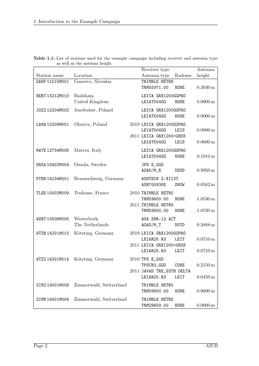
Data from thirteen European stations of the International GNSS Service (IGS) net-
work and from the EUREF Permanent Network (EPN) were selected for the example
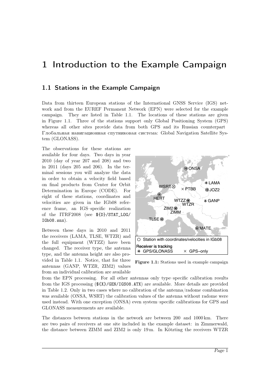
campaign. They are listed in Table 1.1. The locations of these stations are given
in Figure 1.1. Three of the stations support only Global Positioning System (GPS)
whereas all other sites provide data from both GPS and its Russian counterpart
Globalьna navigacionna sputnikova sistema: Global Navigation Satellite Sys-
tem (GLONASS).
The observations for these stations are
available for four days. Two days in year
2010 (day of year 207 and 208) and two
in 2011 (days 205 and 206).
In the ter-
minal sessions you will analyze the data
in order to obtain a velocity field based
on final products from Center for Orbit
Determination in Europe (CODE). For
eight of these stations, coordinates and
velocities are given in the IGb08 refer-
ence frame, an IGS–specific realization
of the ITRF2008 (see ${D}/STAT_LOG/
IGb08.snx).
,
ONSA
LAMA
JOZ2
GANP
WSRT
PTBB
HERT
WTZZ
WTZR
ZIM2
ZIMM
TLSE
MATE
GPS−only
Receiver is tracking
Receiver is tracking
GPS/GLONASS
Station with coordinates/velocities in IGb08
Between these days in 2010 and 2011
the receivers (LAMA, TLSE, WTZR) and
the full equipment (WTZZ) have been
changed. The receiver type, the antenna
type, and the antenna height are also pro-
vided in Table 1.1. Notice, that for three
antennas (GANP, WTZR, ZIM2) values
from an individual calibration are available
from the EPN processing. For all other antennas only type–specific calibration results
from the IGS processing (${X}/GEN/IGS08.ATX) are available. More details are provided
in Table 1.2. Only in two cases where no calibration of the antenna/radome combination
was available (ONSA, WSRT) the calibration values of the antenna without radome were
used instead. With one exception (ONSA) even system–specific calibrations for GPS and
GLONASS measurements are available.
Figure 1.1: Stations used in example campaign
The distances between stations in the network are between 200 and 1000 km. There
are two pairs of receivers at one site included in the example dataset:
in Zimmerwald,
In Kötzting the receivers WTZR
the distance between ZIMM and ZIM2 is only 19 m.
Page 1
�
1 Introduction to the Example Campaign
Table 1.1: List of stations used for the example campaign including receiver and antenna type
as well as the antenna height.
Station name
GANP 11515M001 Ganovce, Slovakia
Location
HERT 13212M010 Hailsham,
United Kingdom
JOZ2 12204M002
Jozefoslaw, Poland
LAMA 12209M001 Olsztyn, Poland
MATE 12734M008 Matera, Italy
ONSA 10402M004 Onsala, Sweden
PTBB 14234M001 Braunschweig, Germany
Receiver type
Antenna type Radome height
TRIMBLE NETR8
TRM55971.00
NONE
Antenna
0.3830 m
LEICA GRX1200GGPRO
LEIAT504GG
NONE
LEICA GRX1200GGPRO
LEIAT504GG
NONE
LEIAT504GG
2010: LEICA GRX1200GGPRO
LEIS
2011: LEICA GRX1200+GNSS
LEIS
LEIAT504GG
LEICA GRX1200GGPRO
LEIAT504GG
NONE
0.0000 m
0.0000 m
0.0600 m
0.0600 m
0.1010 m
JPS E_GGD
AOAD/M_B
OSOD
0.9950 m
ASHTECH Z–XII3T
ASH700936E
SNOW
0.0562 m
TLSE 10003M009 Toulouse, France
2010: TRIMBLE NETR5
TRM59800.00
NONE
1.0530 m
2011: TRIMBLE NETR9
TRM59800.00
NONE
1.0530 m
WSRT 13506M005 Westerbork,
The Netherlands
WTZR 14201M010 Kötzting, Germany
AOA SNR–12 ACT
AOAD/M_T
DUTD
LEIAR25.R3
2010: LEICA GRX1200GGPRO
LEIT
2011: LEICA GRX1200+GNSS
LEIT
LEIAR25.R3
0.3888 m
0.0710 m
0.0710 m
WTZZ 14201M014 Kötzting, Germany
2010: TPS E_GGD
ZIM2 14001M008 Zimmerwald, Switzerland
ZIMM 14001M004 Zimmerwald, Switzerland
TPSCR3_GGD
CONE
0.2150 m
2011: JAVAD TRE_G3TH DELTA
LEIAR25.R3
LEIT
0.0450 m
TRIMBLE NETR5
TRM59800.00
TRIMBLE NETRS
TRM29659.00
NONE
0.0000 m
NONE
0.0000 m
Page 2
AIUB
�




 2023年江西萍乡中考道德与法治真题及答案.doc
 2012年重庆南川中考生物真题及答案.doc
 2013年江西师范大学地理学综合及文艺理论基础考研真题.doc
 2020年四川甘孜小升初语文真题及答案I卷.doc
 2020年注册岩土工程师专业基础考试真题及答案.doc
 2023-2024学年福建省厦门市九年级上学期数学月考试题及答案.doc
 2021-2022学年辽宁省沈阳市大东区九年级上学期语文期末试题及答案.doc
 2022-2023学年北京东城区初三第一学期物理期末试卷及答案.doc
 2018上半年江西教师资格初中地理学科知识与教学能力真题及答案.doc
 2012年河北国家公务员申论考试真题及答案-省级.doc
 2020-2021学年江苏省扬州市江都区邵樊片九年级上学期数学第一次质量检测试题及答案.doc
 2022下半年黑龙江教师资格证中学综合素质真题及答案.doc